11
Catherine's Site
Mark D. Varien
Contents
- Pit Structure and Courtyard (Sampling Strata 2 and 3)
- Inner Periphery (Sampling Stratum 4)
- Probability Sampling Units
- Sampling Units 86N/128E, 85N/128E, 81N/122E, 79N/122E, 77N/124E, 75N/124E, and 75N/126E
Sampling Units 84N/108E and 91N/109E
Sampling Unit 92N/134E
Sampling Unit 105N/124E - Inner Periphery Artifacts
Inner Periphery Summary and Interpretations
- Midden (Sampling Stratum 5)
- Probability Sampling Units
- Sampling Units 86N/113E and 83N/114E
Sampling Units 87N/123E and 87N/124E
Sampling Unit 90N/129E
Sampling Unit 95N/127E
Sampling Units 87N/115E, 87N/119E, 89N/120E, and 89N/122E - Features 1 and 2 (Retaining Walls)
Midden Artifacts
Midden Interpretations
North Outer Periphery (Sampling Stratum 6)
- South Outer Periphery (Sampling Stratum 7)
- The Spring and Agricultural Terraces
South Outer Periphery Summary and Interpretations
Catherine's Site Conclusions and Interpretations
Introduction
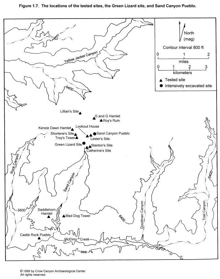
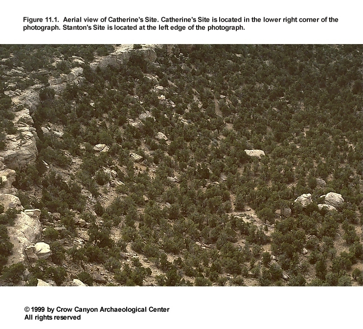
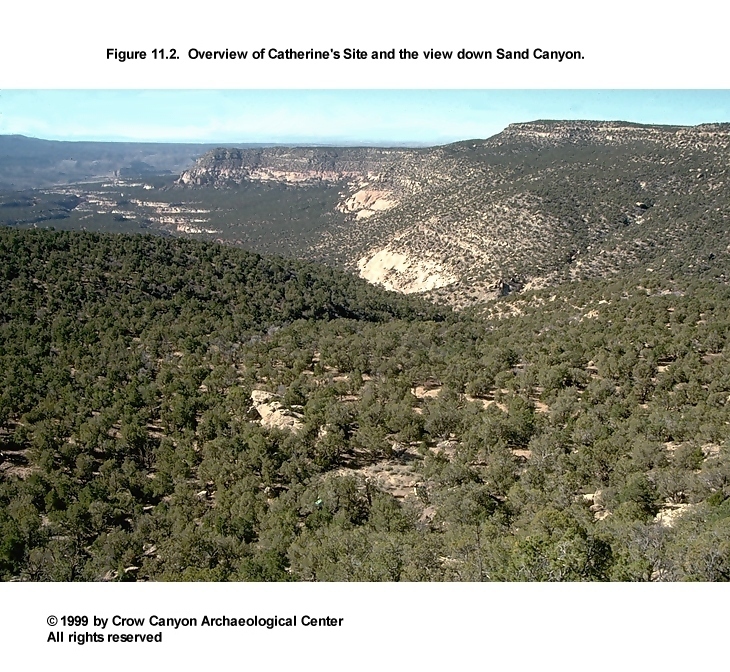
Crow Canyon survey crews recorded Catherine's Site during the 1987 field season as CC87-281 (Adler 1988), and it was subsequently assigned site number 5MT3967. It was excavated in 1989 as part of the Sand Canyon Archaeological Project Site Testing Program. The site sits on a bench, or terrace, inside Sand Canyon, at an elevation of 2060 m (6760 ft) (Figure 1.7). The easiest access to the site today is by means of a trail that winds through cracks in a 30-m-high sandstone cliff and then drops down the talus slope to the terrace. The talus is approximately a 24 degree slope; the terrace is approximately a 3 degree slope (Figure 11.1 and Figure 11.2). Catherine's Site lies almost 1.4 km south of Sand Canyon Pueblo. Sand Canyon is the closest major drainage, but a small tributary that flows into Sand Canyon is approximately 100 m south of Catherine's Site.
Pinyon and juniper are the primary forms of vegetation covering Catherine's Site. Rabbitbrush, sagebrush, saltbush, Mormon tea, and wide- and narrow-leaf yucca are among the other types of vegetation present. A small cottonwood grows on the west edge of the site, marking what may have been an important spring. Large sandstone boulders are strewn over the entire terrace. At Catherine's Site, and at other sites on the terrace, the prehistoric architecture often abuts these boulders.
The difficult access has limited the use of the terrace in historic times. Livestock may have once grazed this terrace, but there was no evidence of recent grazing. Historic-period vandalism of the site includes shovel excavations in the midden and the roomblock.
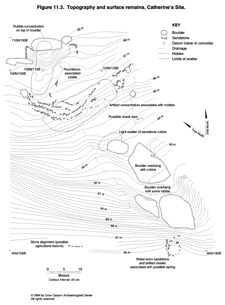
Surface remains at Catherine's Site include a rubble mound, several retaining walls, and a midden with abundant artifacts and gray brown soil. Isolated areas of rubble next to several large boulders are located on the periphery of the site (Figure 11.3). The pit structure depressions were not obvious, so the definition of the pit structure sampling stratum relied on our knowledge of normative small-site layout (that is, the fact that pit structures typically are located in front of the roomblocks). The main rubble mound abuts a boulder, on top of which an additional small amount of rubble is present. The latter may have been a tower at one time, but preservation is so poor that this cannot be confirmed.
Sampling stratum boundaries were drawn on the basis of the surface remains (Figure 11.3 and Figure 11.4). The surface rubble associated with the contiguous-room masonry roomblock became Sampling Stratum 1. Sampling Stratum 2 is the pit structure sampling stratum. Pit structure depressions are not visible on the surface. Sampling Stratum 2 boundaries therefore were drawn on the basis of where pit structures are normally found on small sites--the area south of the roomblock. Sampling Stratum 3 is the courtyard area surrounding the pit structure sampling stratum and partly enclosed by the retaining walls.
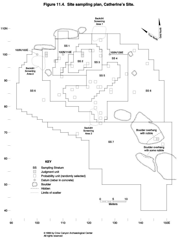
Sampling Stratum 4 is the inner periphery, the area that surrounds the major cultural units on the site. No obvious architectural remains are visible on the surface in Sampling Stratum 4, but subsurface features and nonmasonry rooms sometimes occur in this area. The surface artifact density in Sampling Stratum 4 is greater than the surface artifact density in the outer periphery, but not as great as in the midden.
Sampling Stratum 5 is the midden (provenienced as Nonstructure 1 during excavation). The midden contains multiple retaining walls, a dense artifact scatter, and sediments that are more gray brown than the sediments outside the midden.
The outer periphery is the light artifact scatter on the edges of the site. Sampling Stratum 6 is the outer periphery surrounding Sampling Stratums 1 through 5. Sampling Stratum 7 is the outer periphery on the south, downslope edge of the site.
The testing at Catherine's Site included the excavation of 41 randomly selected (probability) sampling units and six judgmentally located test pits. In addition, sweeping and troweling in the rubble mound exposed wall alignments and produced a partial outline of the roomblock. Figure 11.5 illustrates the major cultural units uncovered by these excavations. These include two masonry-lined pit structures (kivas), a masonry roomblock, and a midden with multiple retaining walls. These features date to the Pueblo III occupation at Catherine's Site and indicate that the site functioned as a year-round habitation during that time. The types of pottery recovered from the site indicate that Pueblo I and II components are also present at Catherine's Site. We did not encounter architectural features that date to either of those periods, but several pit features may have been constructed during the Pueblo II occupation. The relatively small amount of Pueblo II pottery, and the absence of architectural features that date to that period, indicates that the Pueblo II use of the site was probably limited and seasonal. The Pueblo I occupation resulted in the deposition of even less material than the Pueblo II use of the site.
The Catherine's Site grid is oriented to the exposed walls in the roomblock and to the slope of the terrace. Grid north is 44 degrees east of magnetic north. Three grid points are permanently marked with rebar set in concrete. Vertical datum A is an "X" ground into the boulder at the north end of the roomblock; we assigned this datum an arbitrary elevation of 100 m. Additional vertical data points include the tops of the rebar used in the grid. Directions given in text are based on the grid orientation, not on true north.
The following descriptions are organized by sampling stratum. Cultural study units discovered within a sampling stratum are discussed first, followed by the descriptions of the sampling units where no cultural study units were encountered. Sampling stratum descriptions include both the probability and judgmentally located sampling units.
Roomblock Rubble Mound (Sampling Stratum 1)
Sampling Stratum 1 is the masonry surface architecture sampling stratum. The Catherine's Site rubble mound is somewhat unusual. Rooms abut a large boulder on the north end of the rubble mound. Rubble on top of the boulder is evidence that there was once a room (possibly a tower) on top of the boulder.
Vandals exposed a portion of two walls associated with the room that abuts the boulder. The rubble mound and the tops of the walls on this end of the roomblock are over 1.5 m high. Toward the south there is much less rubble so that on the south end of the roomblock the rubble mound is only 50 cm high. Excavations exposed walls at this end of the roomblock and they were a maximum of two courses high.
One hundred and eight sampling units are present in Sampling Stratum 1; excavation took place in four of these sampling units (97N/107E, 98N/108E, 93N/109E, and 94N/109E). These sampling units, except possibly 98N/108E, lie just outside masonry rooms. It is not clear if 98N/108E is inside or outside a room. A single feature, a burned spot, occurs in Sampling Stratum 1, in 98N/108E.
Sampling Units 93N/109E and 94N/109E
Excavation in these sampling units removed two strata of fill. Stratum 1 is wall fall in a brown loam matrix. Wall fall ranged from 40 cm thick on the north end of these two sampling units to 10 cm thick on the south end. We found a wall that ran along the west side of the sampling units after the wall fall was removed. The base of the wall fall is at approximately the same elevation as the base of the masonry wall. The wall is described in greater detail below.
Another stratum of cultural fill was found beneath the wall fall and the masonry wall; the masonry rooms appear to be constructed on top of this stratum of cultural fill. Stratum 2 is a brown to gray brown silt loam. Small angular sandstone and charcoal flecks are the main inclusions. In most of the two sampling units, this stratum of cultural fill rests on bedrock that sloped down from north to south. There was no bedrock at the southern end of 93N/109E, but red brown sandy clay loam sediments with angular gravels were present and interpreted as sterile. Stratum 2 was approximately 40 cm thick. The majority of artifacts from Sampling Stratum 1 come from Stratum 2 in these two sampling units. Decorated white wares from Stratum 2 include both Pueblo II and III types. The Pueblo II pottery includes Mancos Black-on-white (N = 1), Late White Painted with mineral paint (N = 10), and Pueblo II White Painted (N = 5). Pueblo III pottery in Stratum 2 includes Late White Painted with carbon paint (N = 10) and Pueblo III White Painted (N = 2). Other artifacts recovered from Stratum 2 include one metate fragment, two peckingstones, three cores, one modified sherd, and a bone tube fragment. Stratum 2 appears to be a refuse deposit based on the artifact content and the gray brown color of the sediment. Stratum 2 could be fill brought from elsewhere on the site to create a level foundation for the construction of the roomblock. Alternatively, it could be secondary refuse that accumulated during an occupation of the site that predates the construction of the room.
The wall found along the west side of the sampling units stops 30 cm north of 93N/109E; the point where the wall stops is believed to be the corner of the roomblock. The exposed wall was one to two courses high and appeared to be double-stone wide in cross section.
Sampling Units 97N/107E and 98N/108E
Sampling unit 97N/107E is just west of the west wall of the roomblock. Excavation removed a 20- to 30-cm-thick stratum of wall fall as Stratum 1. Beneath the wall fall was Stratum 2, a 10 cm deposit of red brown silt loam with charcoal flecks and a few artifacts. Stratum 2 stopped when sterile B-horizon sediments were found. Artifacts were scarce in both Strata 1 and 2.
Sterile covered the entire sampling unit, except in the southwest corner. Here a concentration of sandstone was still present. A 1.0 by .5 m test pit placed next to sampling unit 97N/107E exposed the entire feature. The sandstone turned out to be fill in the Structure 1 vent shaft. This is discussed further under the description of Structure 1.
Sampling unit 98N/108E is just 10 cm north of a masonry wall. Stratum 1 is wall fall 12 to 15 cm thick. A surface (Surface 1) lies at the base of the wall fall. There is a prepared adobe surface in the southeast corner of the sampling unit. A use-compacted surface was present in the remainder of the sampling unit. A burned spot, Feature 1 of Sampling Stratum 1, was found on this surface on the west edge of the sampling unit (see discussion of Feature 1, below).
Excavation continued 30 cm below Surface 1. This material is Stratum 2; the wall fall that characterized Stratum 1 was entirely absent. Stratum 2 sediments are a sandy silt and range in color from a dark brown on the top of the stratum to a more yellow brown at the base of the stratum. Small, angular sandstone inclusions are present throughout the stratum. Almost all the artifacts recovered from Stratum 2 came from the upper 5 cm, but charcoal flecks continued for 20 cm below the surface. The final 10 cm of Stratum 2 contained no cultural inclusions. This is interpreted as native colluvium deposited naturally before the occupation of the site.
Feature 1 (Burned Spot)
This feature is an irregularly shaped area of burned sediment with charcoal inclusions. The burned spot measured 24 cm long, 15 cm wide, and 1 cm deep. The burned spot is the location of a fire that may have functioned as a hearth for heating or food processing. Because the burned spot is on the surface and not in a pit, it may have been used infrequently, perhaps just once.Sampling Stratum 1 Interpretations
Sampling Stratum 1 is the masonry roomblock sampling stratum. The Sampling Stratum 1 sampling units, except perhaps 98N/108E, landed outside rooms. The sampling units were therefore helpful in defining the boundaries and layout of the roomblock, but did not provide information on the stratigraphy inside the rooms. Excavation did reveal that the roomblock is constructed on top of a stratum of cultural fill. This fill contains Pueblo II pottery and may have accumulated during that period. The masonry roomblock is believed to date to the Pueblo III period, probably during the A.D. 1200s.
Sweeping of the wall outlines showed that at least four masonry rooms are present in the roomblock. A single room was probably present on top of the boulder at the north end of the roomblock. Additional rooms may be present to the east and west of the outlined rooms. If they are present, they have almost no wall preservation and little rubble associated with them. The most likely location for additional masonry rooms is east and west of the room that abuts the boulder.
The room that abuts the boulder appears to be well preserved, and its associated rubble mound is over 1.5 m high. South of this room the rubble mound slopes down, so that on the south end of the roomblock the walls are only two courses (30 cm) high. There does not appear to be enough wall fall to reconstruct full-height masonry rooms except in the room closest to the boulder.
It is not clear what type of abandonment or postabandonment processes could have resulted in contiguous rooms collapsing in such different ways. Several possibilities can be suggested. Some rooms may not have had full-height masonry walls, and this may explain the poor wall preservation and lack of wall fall. Another explanation is that the wall fall from the rooms on the south end of the roomblock fell into the pit structure depressions. Structure 2, a pit structure located 3 to 4 m to the east, had a thick stratum of stone that appeared to come from the roomblock. This stratum of stone lies near the floor of the pit structure. Therefore, the deposition of the stone took place shortly after pit structure abandonment. Further, the stones lay in sediments believed to be culturally deposited.
Rooms on the south end of the roomblock may have been deliberately dismantled shortly after site abandonment to salvage roof timbers. The room next to the boulder may have been left standing. Sites abandoned as habitations may continue to be used as limited-activity sites (for example, as field houses), and in such cases, a single room might be left intact.
Pit Structure and Courtyard (Sampling Strata 2 and 3)
Sampling Stratum 2 is the pit structure sampling stratum and Sampling Stratum 3 is courtyard sampling stratum. Fifty-nine sampling units are present in Sampling Stratum 2. Excavation took place in four randomly selected sampling units (101N/120E, 96N/119E, 95N/118E, and 95N/113) and two judgmentally located test pits (100N/117E and 99N/117E). Randomly selected sampling units did not locate any pit structures, but they did isolate the area where the pit structure would most likely be found. The two judgmentally located test pits were excavated in this area, and Structure 2 was discovered.
Sampling Stratum 3 is the courtyard sampling stratum, and it consists of 79 sampling units. Excavation took place in four of these sampling units (101N/121E, 101N/124E, 99N/124E, and 96N/111E).
Structure 2 excavations will be presented first, followed by the Sampling Stratum 2 and 3 probability sampling units that did not encounter structures.
Structure 2
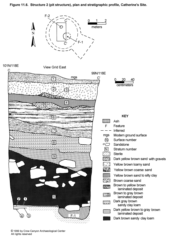
The Sampling Stratum 2 randomly selected sampling units did not land in any pit structures. By telling us where the pit structure was not, however, we isolated the area to test for a pit structure. Excavation in judgmentally selected test pits (99N/117E and 100N/117E) located a pit structure, Structure 2. These test pits landed in the center of the structure, uncovering a portion of the main chamber floor, but they did not expose the pit structure walls. It is not clear if this pit structure has the architectural attributes of a kiva (Figure 11.6).
Structure 2 test excavations reveal extensive remodeling of the Structure 2 floor. Three (possibly four) surfaces were documented. Two floor features, the west half of the hearth, and a small bell-shaped cist are present in the exposed segment of the Structure 2 floor.
Structure 2 dimensions can be estimated by using the location of the hearth and the surrounding sampling units that lay just outside of Structure 2. To fit in the area between the sampling units, the maximum diameter of Structure 2 would be 5 m, and 4 m in diameter is a more reasonable estimate. Structure 2 is exceptionally deep; Surface 1 of Structure 2 lies 2.9 m below modern ground surface.
Construction
Walls. The walls of Structure 2 were not exposed during testing; therefore, it is unknown whether they are of earthen or masonry construction.
Roof. The only evidence for the roof is the unburned adobe and small fragments of unburned wood in the fill covering the floor. The presence of the adobe and the absence of large decomposed roof timbers in the fill above the floor indicate that the Structure 2 roof timbers were salvaged at the time of structure abandonment. The evidence for salvaging timbers is presented in greater detail below in the section on stratigraphy.
The adobe nodules are fist-size and typically have soot-blackening on one side. The adobe is similar in color and texture to the floor-construction sediments. These sediments are unlike any native sediments observed on Catherine's Site. They most closely resemble the B horizon in the deep, mesa-top soils. The adobe nodules recovered would be far less than the material needed to cover the entire Structure 2 roof. The adobe nodules may be the remnants of a thin coat of moist sediment applied over the vegetal framework of the roof to better seal the roof. This coat would have hardened into the adobe with vegetal impressions and soot-blackening. A thicker coat of dry sediment would have completed the layered roof construction.
Floors. Four surfaces are present in Structure 2. Three of these are adobe floors; the lowest surface may not be a floor but, rather, fill placed on top of native sediments in preparation for the construction of the overlying adobe floor. These surfaces will be described beginning with the earliest construction and proceeding to the surface in use when Structure 4 was abandoned.
Floor 4
Floor 4 is the top of a 1.5- to 2.5-cm-thick layer of brown to yellow brown silty sand that covers native sediments. The native stratum below this surface is predominantly angular sandstone rock in a dark brown to gray brown clay loam matrix. Inclusions present in these sediments include charcoal flecks and sandstone pebbles up to 1.5 cm in diameter. The sandstone inclusions create a rough surface, which may indicate that this did not function as a floor. It is possible that these sediments are construction fill brought in to cover the rocky native stratum prior to the construction of Floor 3.
Floor 3
Floor 3 is a 1- to 2-cm layer of red brown adobe; the top of this layer of adobe is level and smooth. The adobe used to construct this surface is similar to the sediments used to construct Floors 1 and 2. These red brown sediments are unlike any sediments uncovered at Catherine's Site, and they most closely resemble the native B-horizon sediments in the deep mesa-top soils. It is possible that B-horizon sediments were brought from the mesa top to the site for floor construction. A thin film of sand covers the adobe. This sand is interpreted as sediment that accumulated on the floor during the use of this floor. A thin lens of ash on the floor might be material that spilled from an associated hearth. No artifacts were present on Floor 3, but flotation, pollen, and sediment samples were collected.
Floor 2
Floor 2 consisted of a 2.5-cm layer of red brown adobe. A piece of chipped-stone debris and three corrugated sherds were found when these floor-construction sediments were screened. A small bell-shaped cist, Feature 2, is associated with Floor 2.
A pollen scrape from Floor 2 was analyzed (see Chapter 17). Beeweed pollen in this sample is interpreted as economic pollen, and high values of cheno-am pollen suggest that its presence may be the result of its use in the structure or its abundance in the area around the site when Floor 2 was in use. Sagebrush pollen is also high, and it, too, may have been used in the structure or been abundant in the area around the site.
Feature 2 (Bell-Shaped Pit). Feature 2 is 24 cm in diameter at the opening, 27 cm in diameter at the widest point, and 26 cm deep. The size and shape of the feature suggest that it functioned as a temporary storage feature. Together with the hearth, this would be a part of a food-processing activity area. Nothing was found stored in the feature. Instead, the pit was intentionally filled with yellow brown sandy silt, two sandstone rocks, and unburned adobe with vegetal impressions. Artifacts from the fill include two pieces of chipped-stone debris, two corrugated sherds, one Late White Painted sherd with carbon paint, one Pueblo III Painted sherd, and one Mesa Verde Black-on-white sherd. Floor 1 construction sediments capped Feature 2, so it was not in use during the final period of occupation of Structure 2.
Floor 1
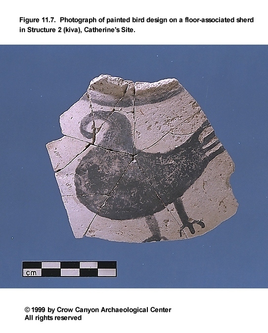
Floor 1 consists of a layer of red brown adobe that ranges from 3 mm to 1 cm thick placed on top of Floor 2. In places, a thin layer of fill covers this adobe. The fill became compacted through the use of Floor 1. Artifacts lying on the adobe surface include a corrugated sherd and a metate. Artifacts on top of the use-compacted fill include a Late White Unpainted sherd (PL 2), a Late White Painted sherd next to the hearth (PL 3), and a sherd cluster above the hearth fill that contains two Late White Unpainted sherds and four Late White Painted sherds. The sherd next to the hearth (PL 3) lay beneath a sandstone slab that may have been deliberately placed over the sherd. The sherd is part of a painted jar that depicts a bird (Figure 11.7). The fact that this particular sherd was left behind and covered by a sandstone slab raises the question of whether its placement was associated with the abandonment processes in Structure 2. This is a question that may never be answered, but a possible interpretation is that the sherd was deliberately left behind as a part of an abandonment ritual. The bird, for example, could be a symbol that represents a group affiliation (for example, a clan symbol) for the people who used Structure 2.
A pollen sample was collected from beneath a slab on this floor. Economic pollen includes corn and cholla. As was the case with Floor 2, high values of cheno-am pollen may be the result of these plants having been used within the structure or their having grown in and around the site. Similarly, the high sagebrush pollen counts may be due to the use of this plant within the structure or its abundance in and around the site during the time Floor 1 was in use.
Feature 1 (Hearth). Excavation exposed the west half of the Structure 2 hearth. This portion of the hearth measures 62 cm in diameter and 30 cm deep. Hearth construction consisted of excavating a pit into the native subfloor sediments and lining the pit with adobe. Use of the hearth oxidized the adobe lining. Hearth remodeling occurred on several occasions. The final coat of adobe covered traces of earlier burned walls, the tops of which were visible on Floor 1. The final hearth remodeling consisted of applying a coat of adobe 4 to 7 cm thick over the earlier hearth walls. The inner wall fell away from the earlier hearth wall during excavation. Additional remodeling events are believed to be present as well, but these earlier walls were not exposed in order to preserve the hearth for archaeomagnetic dating. An archaeomagnetic sample from this hearth produced date ranges of A.D. 1015-1030 and A.D. 1200-1325. The later range is consistent with the pottery found in Structure 2.
Hearth fill consists of a 26-cm-thick stratum of ash. An abrader fragment lay on top of the ash. The ash was collected for fine screening and flotation samples (see Chapter 16). Juniper, pine, serviceberry/squawbush, and sagebrush charcoal were present in these samples and interpreted as fuel. A yucca or corn stalk was also found, as were corn and groundcherry seeds that probably represent food processed in the structure.
Dating
Tree-ring dates from small unburned wood fragments and charcoal pieces in the fill above the floor did not produce cutting dates and do not clarify the dating of this structure (the noncutting dates are A.D. 938, 992, 1016, and 1111). The A.D. 1200-1325 archaeomagnetic date is consistent with the Mesa Verde Black-on-white pottery found in the fill of Feature 2. The Mesa Verde-region abandonment took place between A.D. 1280 and 1300, so this structure was abandoned before 1300. Further, salvaging of the Structure 2 roof timbers at the time of structure abandonment indicates that Structure 2 was abandoned before the region was abandoned; the timbers were presumably reused somewhere nearby Catherine's Site. Thus, Structure 2 use probably dates sometime between A.D. 1200 and 1270.
Stratigraphy
Figure 11.6 illustrates the Structure 2 profile. This profile was interpreted in consultation with geomorphologist Fred Nials.
The Structure 2 profile is similar to the other pit structure profiles exposed during the Testing Program in that a thick deposit covers the floor. This deposit, Stratum 10, is a brown to dark brown sandy clay loam over 1 m thick. The upper 60 cm contains large pieces of sandstone. Much of this sandstone has pecked surfaces and presumably comes from the masonry roomblock located 3 m east of Structure 2. The lower 40 cm of Stratum 10 contains unburned adobe, charcoal up to 3 cm in diameter, calcium carbonate flecks, sandstone 1 to 2 cm in diameter, and a few small pieces of unburned wood.
Stratum 10 is interpreted as unburned roof fall that was deposited when Structure 2 was abandoned. Stratum 10 does not have the microstratigraphy characteristic of wind and water deposition (sediments sorted by particle size). Instead, Stratum 10 was probably deposited as dry aggregates of unconsolidated material. The adobe, charcoal, and calcium carbonate inclusions are not eroded as they would be if they had been transported by natural processes or subjected to weathering after they were deposited. This indicates that deposition of this material took place quickly and it was covered quickly. There is no evidence of bedding planes in the sediment below the rocks or between the rocks. Large inclusions within the stratum (for example, sandstone) are oriented at different angles to one another, which also indicates rapid deposition; natural deposition, on the other hand, would tend to orient the large inclusions uniformly parallel to the existing bedding plane.
A few small fragments of unburned wood are present in Stratum 10, but no evidence is present that all the timbers from the Structure 2 roof fell and rotted in place. The Structure 2 roof probably contained hundreds of beams. Unburned roofs found elsewhere in Sand Canyon Project excavations (for example, Structure 1205 at Sand Canyon Pueblo and Structures 10, 12, and 14 at Kenzie Dawn Hamlet) still have the rotting timbers present. If timbers had completely decomposed, Stratum 10 would not only have a high organic content, but dislocation adjustments should be visible in the profile where sediment from strata above settle into the void left by the decomposed timbers. Therefore, the Structure 2 timbers were probably salvaged as a part of the abandonment of the structure.
The hardened adobe inclusions appear to have been sediments transported to the site for construction material. This adobe appears to be the mesa-top loess (B horizon). The adobe is hard and has vegetal impressions, indicating that it was probably applied to the Structure 2 roof when it was wet. The remainder of the Stratum 10 sediment may be material obtained at the site; this sediment resembles the Structure 2 subfloor native sediments in terms of color, texture, and the small sandstone and calcium carbonate inclusions. Backdirt produced from Structure 2 excavation was probably used as the layer of dry sediment applied as the last layer in the Structure 2 roof construction.
Stratum 9 is a natural deposit that consists of a series of sorted laminae with the coarse material on the bottom and the fine-grained material on the top. The laminae indicate water deposition. Stratum 9 sediments range in color and texture from a dark yellow brown fine sand to a gray brown clay. The top of Stratum 9 is a clay lens up to 9 cm thick that probably accumulated when there was standing water and ponding of sediments. Some charcoal flecks and tiny calcium carbonate flecks are present as inclusions.
Stratum 8 is a dark gray brown sandy clay loam. Small sandstone (.5 to 5 cm) and charcoal flecks are common inclusions. Two larger pieces of sandstone are also present. Some weak laminae are visible, but the lenses do not run for more than 25 cm. Stratum 8 may be a mix of cultural and natural deposition.
Stratum 7 is another natural deposit consisting of at least three coarse to fine laminae. Yellow brown silt fines upward into more gray brown silty clay. Stratum 7 may be another deposit where there was standing water and ponding in the abandoned pit structure depression. Inclusions are almost absent in Stratum 7.
Stratum 6 is a thick, water-deposited layer that may have formed as the result of a single storm. Stratum 6 is predominantly brown to yellow brown sand that fines upward from coarse- to medium-grained sand. At least five thin, silty clay lenses are present within Stratum 6 that represent periods when the velocity of the water transporting the sediment slowed. There are no inclusions in Stratum 6. The top of Stratum 6 is a clay lens 1 to 2 cm thick; this upper boundary is abrupt but irregular, with pockets greater than 4 cm. The top of Stratum 6 is an eroded surface, indicating that material was flowing through and out of the Structure 2 depression at this point.
Stratum 5 is brown sediment that fines upward from granule-size particles on the bottom to coarse sand on the top of the stratum. Stratum 4 displays faint laminae, indicating deposition by water. Sediments are yellow brown and range from medium sand to silty clay. Stratum 3 is a yellow brown stratum that is granule-size on the bottom and coarse sand on the top. Stratum 2 is predominantly yellow brown loamy sand. Faint lenses of darker sediment, perhaps due to the presence of increased organic material, lie within Stratum 2. Stratum 1 is a yellow brown to dark yellow brown coarse sand with abundant gravel inclusions.
Structure 2 Interpretations
Structure 2 is a deep pit structure occupied during the Pueblo III occupation of Catherine's Site. Archaeomagnetic dating and stratigraphy place the Structure 2 occupation between A.D. 1200 and 1270. There was extensive remodeling of Structure 2, including three separate floors and remodeling of the hearth. The remodeling episodes indicate that Structure 2 had a long use life.
Structure 2 use is difficult to determine given the limited testing. The hearth and associated small bell-shaped cist may be part of a food-processing activity area. The storage cist was capped and not in use during the final period of Structure 2 occupation, so the use of this structure may have changed over time.
Abandonment processes can be inferred from floor context artifacts and fill stratigraphy. A large sherd with a bird figure painted on it lay beneath a sandstone slab on the final floor of Structure 2. This sherd may have been deliberately left behind as a part of the abandonment. The roof timbers were salvaged during Structure 2 abandonment, and the unburned sediments from the roof covered the floor. Stone from the surface roomblock also lay in the stratum of fill above the Structure 2 floor. Surface rooms may have been partially dismantled to salvage timbers when Structure 2 was abandoned.
Probability Sampling Units
Sampling Units 95N/118E and 96N/119E
These two sampling units are located at the south end of Sampling Stratum 2. No structures or cultural features were found. Excavation in both sampling units went down to bedrock in 20 cm levels. Sediments were predominantly a brown to gray brown sandy silt with charcoal flecks, calcium carbonate flecks, and small amounts of sandstone. Vandals had disturbed the upper levels in each sampling unit. The remainder of the upper fill in these two sampling units is interpreted as postabandonment natural deposits.
Bedrock covered the entire unit in 95N/118E at a depth that ranged between 42 and 87 cm below modern ground surface. Bedrock covered only the south end of 96N/119E, so the bedrock is apparently a large, buried boulder. The exposed portions of the boulder in 96N/119E lie between 73 and 85 cm below the modern ground surface. A stratum of clean brown sand found in the northern two-thirds of 96N/119E, 60 cm below the modern ground surface, slopes down to the north. This sand stratum was a maximum of 20 cm thick at the north edge of the square. The sloping stratum indicates that sampling unit 96N/119E lies immediately south of Structure 2. A thin stratum of red brown sandy clay loam with abundant angular gravels covers the bedrock. These red brown sediments contained no artifacts or cultural inclusions (for example, charcoal) and are interpreted as sterile sediments present prior to the site occupation.
Artifacts in these two sampling units were relatively scarce, despite the depth of the deposits. Fifty-six sherds were found, and only two of these clearly predate the Pueblo III occupation. These are two Early White Painted sherds found in the upper levels, which appear to be materials mixed by historic looting at the site.
Sampling Unit 95N/113E
This Sampling Stratum 2 unit lies between the roomblock and the pit structure, Structure 2. Stratum 1 in this sampling unit was a postabandonment natural deposit consisting of brown silt with charcoal flecks and small sandstone inclusions. A sandstone rock alignment at the base of Stratum 1 was excavated as Feature 1 (see discussion of Feature 1, below).
Stratum 2 contained artifacts, charcoal, sandstone, and pieces of burned adobe. Stratum 2 is approximately 50 cm thick. Red brown sandy clay loam with no cultural inclusions lies beneath Stratum 2; these red brown sediments are interpreted as the sterile pre-occupation stratum.
Seventy-eight sherds were recovered from this sampling unit. Pueblo III White Painted was found near the bottom of Stratum 2, and only one decorated white ware has mineral paint. The pottery present indicates that the deposits in this sampling unit accumulated during the Pueblo III occupation of the site.
Feature 1 (Wall). Feature 1 of Sampling Stratum 2 is a linear alignment of rocks. This feature was similar to the retaining walls found in the midden. Large, unshaped rocks one course high lie in a row, with the tops of the stones located just below the modern ground surface and the bottoms of the stones located at the base of Stratum 1 (interpreted as a postabandonment natural deposit). Like the midden retaining walls, a stratum of cultural fill (Stratum 2) lies beneath Feature 1. The rock alignment was not part of a structure, and it did not appear to extend far to either the north or the south beyond the limits of the sampling unit. The Feature 1 stones may rest on a use-compacted surface. This surface lies 11 cm below the modern ground surface. There were traces of oxidation on this surface, so there may have been a fire associated with its use.
Sampling Unit 96N/111E
This Sampling Stratum 3 unit is east of a masonry room. It is possible that this unit is inside a room as well, but it is off the main rubble mound. No clear wall outlines were found in the area around the sampling unit, and no clear surface could be defined inside this sampling unit. The unit was excavated to a depth of 60 to 67 cm. Three strata were identified during excavation, and additional strata were identified during the process of cleaning and recording the profile. One feature, a cylindrical pit, was also excavated in this sampling unit.
The upper 15 to 20 cm appears to be a postabandonment natural deposit consisting of brown to yellow brown (the sediments get more yellow with depth) silty sand. Sandstone, charcoal flecks, and some calcium carbonates are present as inclusions. Below this is 25 to 28 cm of brown sandy silt with an increase in charcoal and small sandstone inclusions. Artifact density in this stratum is relatively low, and the deposit does not appear to be secondary refuse. It does appear to be fill that accumulated during the occupation of the site. The charcoal inclusions are heaviest in the upper 10 cm of this stratum, and the sandstone inclusions are heaviest in the lower 15 cm. Feature 1, a cylindrical pit, was first discovered near the base of this stratum, 42 cm below the modern ground surface (see discussion of Feature 1, below).
The excavation of this sampling unit was completed with a 20-cm level excavated into sediments that are more red brown and finer textured than the upper fill. These sediments contain abundant sandstone gravel but almost no cultural inclusions. The base of this lower stratum is interpreted as sterile.
All of the decorated white ware sherds recovered from this sampling unit have carbon-paint designs. Thus, the deposits in this portion of the site probably accumulated during the Pueblo III occupation of the site.
Feature 1 (Pit). This roughly cylindrical pit measured 29 cm long, 24 cm wide, and 45 cm deep. The fill of the feature was loosely compacted compared with the surrounding matrix, and there was little difference in color or texture between the surrounding sediments and the pit. The feature may be a post hole, judging from the shape of the pit, but no remains of a post were found in the fill. Mesa Verde Black-on-white pottery was present in the feature fill, indicating that it filled during the late occupation of the site.
Sampling Units 101N/120E and 101N/121E
Sampling unit 101N/120E is in Sampling Stratum 2; 101N/121E is in Sampling Stratum 3. These contiguous sampling units lay just outside of Structure 2. Excavation in these units used a combination of strata and levels. Many of the strata could not be seen until the profile was recorded. Figure 11.8 illustrates the stratigraphic profile of these sampling units.
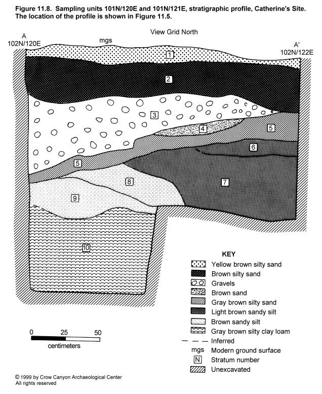
Stratigraphy. Strata 1, 2, 3, and 4 are postabandonment natural deposits that were transported primarily by water and gravity from the talus slope above the site. Stratum 1, the uppermost stratum, is a yellow brown silty sand with abundant gravel inclusions. Stratum 1 ranges between 8 and 14 cm thick. Stratum 2, which is 22 to 36 cm thick, has a lighter (less brown) color and fewer gravel inclusions than Stratum 1. Stratum 3 consists primarily of angular sandstone that ranges in size from 1 to 10 cm. This sandstone lays in a matrix of brown sand. Stratum 3 ranges from 56 cm thick on the west side of the stratum to 4 cm thick on the east side of the stratum. Multiple beds could be seen within Stratum 3, and the gravels were lying flat and oriented the same as the bedding planes. The shape of the stratum and the sorting of the inclusions suggest that this deposit is the fill in a shallow drainage that cut through the site after abandonment. Stratum 4 is a brown sand lens, interpreted as another postabandonment natural deposit.
Stratum 5 is the first cultural stratum encountered. It is a gray brown silty sand with artifacts and charcoal pieces up to 2 cm in diameter present. Stratum 5 is interpreted as fill that accumulated during the occupation of Catherine's Site. Stratum 5 is thickest and most level on the east end of 101N/121E. It slopes down toward the west, indicating that Stratum 5 may have eroded into the Structure 2 depression immediately after the site abandonment. Pueblo III White Painted pottery was found in this stratum, supporting the interpretation that it dates to the Pueblo III occupation of Catherine's site.
Strata 6, 7, 8, and possibly 9 may be backdirt from the excavation of the pit structure, Structure 2. Each stratum is light brown to medium brown and has a silty sand texture. Slight changes in color, texture, and inclusions distinguish one stratum from the other. Several characteristics lead to the interpretation that these strata are cultural deposits. These include the following observations: inclusions and sediment particles vary considerably in size, and the orientation of the sandstone inclusions does not conform to any bedding planes but, rather, is highly variable. In addition, the material appears to have been deposited as aggregates (that is, in basketloads). Artifacts and charcoal flecks were present in these strata but only in small numbers. The base of Stratum 9 has the red brown color associated with sterile sediments elsewhere on the site, and this red brown sediment is interpreted as the top of the sterile B horizon.
Stratum 10 is a gray brown silty clay loam that gets grayer and finer textured with depth. Stratum 10 has well-developed prismatic structure, some angular and subangular sandstone inclusions, and calcium carbonate veins on the ped faces. No cultural inclusions are present in this stratum. Stratum 10 is interpreted as a B horizon present before the Catherine's Site occupation.
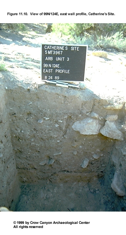
Sampling Units 101N/124E and 99N/124E
These two sampling units lie in the northeast corner of Sampling Stratum 3. Figure 11.9 illustrates the stratigraphy in these two sampling units. Figure 11.10 shows a view of the east wall profile in 99N/124E. Many strata were defined only when the profile was recorded. During excavation, Strata 1 through 5 were excavated as Stratum 1 and subdivided into arbitrary 20 cm levels. Stratum 6 was excavated as Stratum 2, and Stratum 7 was excavated as Stratum 3.
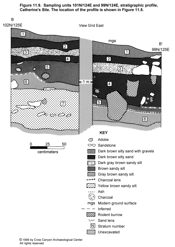
Strata 1 and 2 are both dark brown silty sand interpreted as postabandonment natural deposits. Stratum 1 had abundant sandstone gravels and rocks up to 4 cm; Stratum 2 had noticeably fewer gravels. Cultural inclusions, both artifacts and charcoal flecks, were almost absent in these two strata.
Stratum 3 has a more gray brown color and sediments that are slightly sandier than the sediments in Strata 1 and 2. The presence of charcoal flecks suggests that decomposing charcoal may give this stratum its color. Calcium carbonate flecks are also present, and sandstone gravels are present but less abundant than the strata above. An ash lens was present at the base of this stratum in 99N/124E. The increased charcoal and the ash lens may indicate that Stratum 3 was a cultural deposit that accumulated during the last use of Catherine's Site.
Stratum 4 is similar to Stratum 2, a dark brown silty sand. Faint laminations indicate that water deposited some of the sediments. Stratum 4 may represent a period of site abandonment, followed by a short reoccupation (the latter indicated by Stratum 3).
Stratum 5 is a brown sandy silt; it is slightly lighter in color and coarser in texture than Stratum 4. Stratum 5 inclusions also distinguish it from Stratum 4; calcium carbonate flecks, small to large sandstone gravels, charcoal up to 1 cm diameter, an ash pocket, and unburned adobe are all present in Stratum 5. Stratum 5 is believed to be a deposit that accumulated during the occupation of Catherine's Site. It may be secondary refuse on the edge of the midden; however, the abundance of sandstone gravels suggests that there may be mixing with naturally deposited material (for example, material washing down from the talus slope) as well. Decorated white wares recovered from this stratum are predominantly mineral-painted Pueblo II pottery, including Cortez Black-on-white and Mancos Black-on-white. Carbon-painted white ware is also present, however, including a piece of Mesa Verde Black-on-white.
Stratum 6 is a gray brown sandy silt; the gray brown color is due to the high ash content in the Stratum 6 sediments. Stratum 6 is the only clear deposit of unmixed secondary refuse in the profile. Stratum 6 has noticeably fewer sandstone inclusions than Stratum 5, perhaps an indication that there is less mixing with naturally deposited slopewash. There is an abrupt boundary Stratum 6 and 7. Except for a single carbon-paint sherd, the decorated white wares from this stratum all have mineral-paint decoration and probably are Pueblo II pottery. This appears to be refuse that accumulated during the Pueblo II occupation of Catherine's Site.
Stratum 7 is a yellow brown sandy silt with dense, angular sandstone inclusions. Charcoal flecking and artifacts were present but only in disturbed areas. The top of Stratum 7 may have been the ground surface present when the site occupation began. Stratum 7 at the base of excavation is sterile. As in Stratum 6, the decorated white ware pottery found in this stratum shows predominantly mineral-paint decoration, including one sherd identified as Mancos Black-on-white.
Inner Periphery (Sampling Stratum 4)
Sampling Stratum 4 is the inner periphery, an area of moderate surface artifact density that surrounds the major cultural units on the site. Sampling Stratum 4 contains 395 sampling units. Sampling Stratum 4 excavations include 11 randomly located sampling units (105N/124E, 92N/134E, 91N/109E, 86N/128E, 85N/128E, 84N/108E, 81N/122E, 79N/122E, 77N/124E, 75N/126E and 75N/124E) and three judgmentally located test pits (100N/103E, 99N/103E, and 97N/106.5E). The judgmentally located test pits were excavated after Bruce Bradley visited the site and noticed a slight depression that he thought might be a pit structure. This was not in an area where pit structures were expected based on the normative Pueblo III site layout. A pit structure, Structure 1, was discovered when this area was tested. Sampling Stratum 4 excavation descriptions begin with Structure 1, followed by a discussion of the individual sampling units.
Structure 1 (Kiva)
Structure 1 is a masonry-lined pit structure, what is traditionally referred to as a kiva. Two contiguous, judgmentally located test pits (100N/103E and 99N/103E) exposed a portion of the bench and the main chamber floor in the northeast corner of the structure. The vent shaft was discovered in test pit 97N/106.5E. Structure 1 dimensions can be estimated using the location of the exposed features; Structure 1 diameter is between 4 and 5 m and the main chamber floor is 2.48 m below the modern ground surface. Figure 11.11 is a plan view of the Structure 1 excavations and the stratigraphic profile.
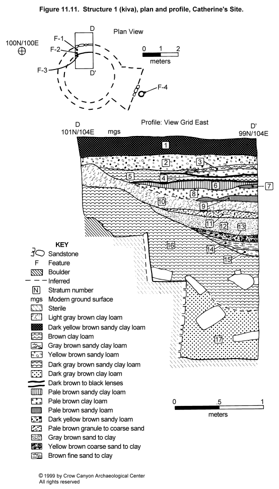
Construction
Walls. The upper lining wall of Structure 1 was constructed with upright sandstone slabs set into adobe mortar. This wall, which forms the back wall of the bench, is 52 cm high and 7 cm thick. The lower lining wall, or bench face, stands 85 cm high and is 12 to 22 cm thick. This wall is horizontally coursed and one stone wide. The coursing ranges between semicoursed and fully coursed. Tabular sandstone was used in the construction of the bench face. Most wall stones display minimal evidence of shaping (pecking, flaking, and grinding). The ventilator shaft and a segment of the south wall of the southern recess were found in a 1 by .5 m judgmentally located test pit (97N/106.5E). Four features were associated with the Structure 1 walls.
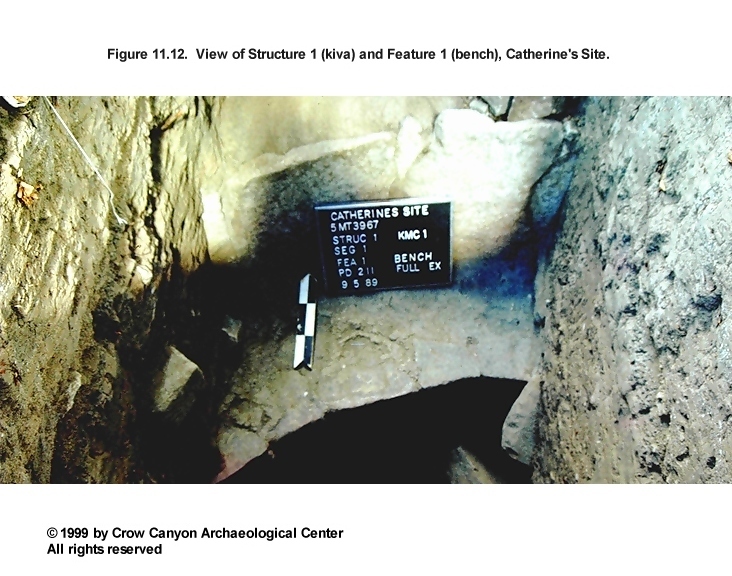
Feature 1 (Bench 4): The bench surface is constructed of a gray brown sandy clay. This surface slopes up from the lower main chamber wall to the upright slabs (Figure 11.12). Adjacent to the upright slabs the bench surface is 6 cm thick. These bench surface construction sediments are helping to hold the upright slabs in place. Several pieces of unmodified sandstone lay on and just above the bench surface. Pollen scrapes were collected from beneath these stones. Two flakes (PLs 3 and 4) and a rodent bone (PL 2) are the only other items found on the bench surface.
Feature 2 (Pilaster 4): Structure 1 excavations exposed a corner of a masonry pilaster. The pilaster rests on top of the bench surface. Three courses of masonry rise to a height of 43 cm. The pilaster stones are heavily shaped, pecked-block masonry.
Feature 3 (Niche): A portion of a niche is present in the lower lining below the pilaster, Feature 2. The niche opening is formed by the stone masonry of the Structure 1 lower main chamber walls. A sandstone slab partially covers the back of the niche. The base of the niche is 16 cm above the floor, and the niche opening is 15 cm high and 25 cm deep. Niche fill is a pale brown to gray clay. This is different than the fill in the Structure 1 main chamber. It is possible that the niche had been deliberately filled and was not in use during the last use of Structure 1.
Feature 4 (Ventilator): The ventilator shaft and a segment of the south wall of the southern recess were found in a 1 by .5 m judgmentally located test pit (97N/106.5E). Initially this feature appeared as a concentration of sandstone in the southwest corner of probability sampling unit 97N/107E; the rocks extended into the judgmental test pit. The concentration of rubble continued down to 84 cm below the modern ground surface where the horizontally coursed masonry wall was discovered. This wall is interpreted as the south wall of the Structure 1 southern recess. The back side of this masonry wall is one wall of the ventilator shaft; the remaining walls of the ventilator shaft are native sediments. The ventilator shaft opening is roughly circular and measures 53 by 48 cm. The shaft was excavated 74 cm below the top of the southern recess wall. Excavation stopped at this point because the rubble fill inside the shaft could no longer be removed.
Fill inside the vent shaft consists of sandstone rubble in a yellow brown silty sand. The stones include shaped masonry blocks that are probably from the roomblock located 1.4 m to the east. The large stones, many the same width as the ventilator opening, were packed tightly into the vent shaft giving the impression that the feature had been deliberately filled.
Roof. Masonry pilasters supported the Structure 1 roof. Roof timbers are not present in the fill above the floor. These timbers may have been salvaged when Structure 1 was abandoned. Structure 1 abandonment is discussed in greater detail below.
Floor. Structure 1 has a single prepared surface. A red brown silty clay loam was used to construct this surface. A bone awl (PL 1) is the only floor artifact.
Dating
No absolute dates were recovered from Structure 1. Late Pueblo III pottery is present in the fill. All of the decorated white ware pottery in the Structure 1 fill has carbon-paint decoration, and two pieces of Mesa Verde Black-on-white were recovered from the fill. This pottery evidence indicates that Structure 1 was filling after A.D. 1180. The absence of any Pueblo II pottery in the fill suggests that Structure 1 was a part of the post-A.D. 1200 occupation of Catherine's Site.
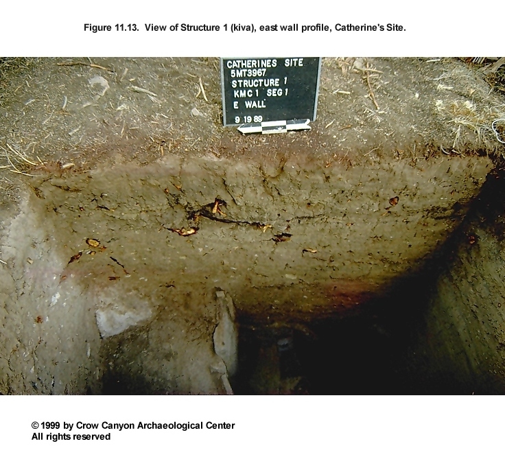
Stratigraphy
Figure 11.11 illustrates the Structure 1 stratigraphic profile. Figure 11.13 shows the east wall stratigraphy in Structure 1. Like most pit structures on the tested sites, Structure 1 has a thick deposit covering the floor. Stratum 17 is a dark gray brown clay loam. Inclusions found throughout the stratum include small (less than 5 cm), angular pieces of sandstone, charcoal flecks, and calcium carbonate flecks. A few large pieces of sandstone are also present. The boundary between stratum 17 and 16 is diffuse. The only difference between the two strata is that Stratum 16 contains slightly more coarse sediment. The color and inclusions in both strata are the same.
There is no evidence to suggest that natural processes deposited Strata 16 and 17; sorting by particle size and bedding planes is absent within the strata. Instead, deposition appears to have occurred as dry aggregates. Inclusions show no evidence of erosion by being transported by natural processes or by exposure to erosion after deposition. This indicates that Strata 16 and 17 deposition occurred rapidly. The larger inclusions lay at a variety of angles and do not have a uniform orientation as would be the case if the stratum was a natural deposit.
There is also no evidence of unburned, rotting roof timbers in Strata 16 or 17. If the unburned roof collapsed naturally, we should see evidence of rotted timbers in the fill. This evidence could include traces of the rotted timbers, high organic content, or, if the timbers had completely disintegrated, dislocation structures where fill collapses into the space left by the rotted timbers.
The color, texture, and inclusions of Strata 16 and 17 resemble the sterile B-horizon sediments observed in sampling unit 101N/120E, Stratum 10. Strata 16 and 17 may have been sediments excavated during the aboriginal excavation and construction of Structure 1. These sediments could have been used as roof construction material and were deposited on the floor when roof timbers were salvaged from Structure 1.
Naturally deposited sediment fills the remainder of Structure 1. The well-defined stratification in this upper fill contrasts sharply with the absence of stratification in the deposits that cover the floor. The strata are predominantly laminated deposits sorted by particle size that result from water deposition. These well-sorted basin-shaped strata could only be deposited if the Structure 1 roof were no longer covering the structure.
Strata 12 to 15 are a series of water-deposited strata that have coarse sand on the bottom and get finer toward the top where they are capped by clay lenses. Strata 12 to 15 have almost no cultural inclusions and are almost identical to one another in terms of color and texture. These strata represent distinct depositional events, and they may represent depositional episodes within a single storm. The clay lens on top of Stratum 12 is the thickest. This may represent a period when standing water was present in the abandoned pit structure depression.
Together these strata resemble Stratum 6 in Structure 2, where the individual depositional events were grouped into one stratum. The thickness, color, texture, and near absence of inclusions in the two deposits in the two structures is remarkably similar, indicating the two structures filled at the same time.
Stratum 11 fines upward from granule-size particles to coarse sand. Stratum 8 and 10 are difficult to distinguish from one another except where the sand lens, Stratum 9, separates them. Strata 8 through 11 appear to have been deposited by water. The top of both Strata 8 and 9 have irregular boundaries and appear to be eroded surfaces. It is at this point that deposition may no longer be contained by the Structure 1 depression. Instead, if the velocity of the depositional event was great enough, water was moving through the structure.
The remaining strata are all interpreted as natural postabandonment deposits. Slight differences in color, texture, and inclusions distinguish one from the other. Two dark lenses with poorly defined boundaries may be lenses of decomposed organic material, essentially buried A horizons.
Structure 1 Interpretations
Structure 1 is a masonry-lined pit structure. Structure 1 has no associated absolute dates, so pottery, stratigraphy, and construction style must be used to date the structure. The location of Structure 1 north of the roomblock differs from the normative unit pueblo layout. This unusual location might indicate that Structure 1 was later than the other architectural units on Catherine's Site, but Pueblo III pottery in the unburned roof fall suggests that Structure 1 was at least partially contemporaneous with the other major architectural features on Catherine's Site. In addition, a stratum in the Structure 2 upper fill is almost identical to a stratum in Structure 1. This may indicate that the abandonment and filling of the two structures took place at the same time. Finally, the masonry construction of Structure 1 is similar to the construction of the Pueblo III masonry-lined kivas exposed on the other sites excavated as a part of the Site Testing Program.
Structure 1 has only one floor, whereas Structure 2 has three, and possibly four, floors. This suggests that Structure 1 was used for a shorter period of time than Structure 2. Structure 1 may have been constructed to accommodate population growth at Catherine's Site, and it may date to the later portion of the occupation of the site. The two kivas may have been abandoned and filled at approximately the same time.
Probability Sampling Units
Sampling Units 86N/128E, 85N/128E, 81N/122E, 79N/122E, 77N/124E, 75N/124E, and 75N/126E
These sampling units lie downslope of the midden, Nonstructure 1. Artifacts in these sampling units are abundant on the modern ground surface and in the upper 10 to 20 cm. In each sampling unit, artifact density decreases as the depth of the excavations increases. This suggests that artifacts in the upper levels washed downslope from the midden after site abandonment. The depth to sterile sediments in these sampling units ranges from 30 to 43 cm. No features are present in these sampling units.
Of the 167 decorated sherds found in this group of sampling units, 166 have carbon-paint designs and one has mineral paint used for the design. The artifacts from these sampling units are therefore predominantly Pueblo III material. This is consistent with the interpretation that this material is postabandonment downslope erosion from the top of the midden.
Sampling Units 84N/108E and 91N/109E
These two sampling units are located west of the midden and south of the masonry roomblock. Bedrock was found in sampling unit 84N/108E between 5 and 10 cm below the modern ground surface. Excavation in sampling unit 91N/109E uncovered two strata before finding sterile at a depth of 42 cm. Both strata are a brown silt loam. The lower stratum is distinguished by an increase in the number of inclusions (angular sandstone, charcoal, and artifacts). The upper stratum may be a postabandonment natural deposit, but the lower stratum accumulated during the site occupation. Pottery in both strata is predominantly Pueblo III pottery. A single mineral-paint sherd was found in each stratum.
Sampling Unit 92N/134E
This sampling unit is on the edge of a shallow gully east of the midden. Artifact density was highest in the first 15 cm. These artifacts probably were transported downslope by natural erosion after the site was abandoned. All of the decorated pottery has carbon-paint designs. Sterile sediments lie 30 cm below the modern ground surface.
Sampling Unit 105N/124E
This sampling unit is located upslope from the midden. Excavation in this sampling unit removed five strata to reach sterile sediments. Sterile sediments are present 95 cm below the modern ground surface. Stratum 1 is a 20-cm-thick layer of dark yellow brown sandy loam with angular sandstone inclusions and little cultural material. It is interpreted as a natural postabandonment deposit.
Stratum 2 is a 22-cm-thick layer of dark brown to brown silty clay loam with charcoal flecks, calcium carbonates, and sandstone inclusions. Small pockets of ash are present throughout the stratum. This stratum could be cultural material that has washed downslope from Stanton's Site. The presence of charcoal and ash, however, suggests that it is a cultural stratum deposited during the last years of occupation at Catherine's Site. Decorated sherds from this stratum all have carbon-paint designs, including six Mesa Verde Black-on-white sherds, supporting the interpretation that this deposit dates to the late occupation of Catherine's Site.
Stratum 3 is a 10-cm-thick layer of brown to dark brown loam with inclusions of sandstone and calcium carbonates. This stratum is a natural deposit. Stratum 4 is a 14-cm-thick deposit of yellow brown sandy loam with abundant sandstone inclusions and some calcium carbonates. Sorting by particle size is present. Several depositional events are represented by a series of fining-upward sequences where small gravels (1 to 2 cm) grade into sand lenses. One lens of larger sandstone (5 cm) is also present. Stratum 4 appears to be slopewash. All the decorated sherds from these deposits have carbon-paint designs, including two Mesa Verde Black-on-white sherds. Thus, these strata appear to have been water-deposited materials that accumulated during the late Pueblo III occupation of Catherine's Site.
Stratum 5 is a 25-cm-thick deposit of brown to dark brown clay loam with abundant charcoal, ash, calcium carbonates, and sandstone. Ash and charcoal content is highest in the lower 10 cm. This stratum contains the highest density of cultural material in this sampling unit. Stratum 5 is interpreted as a cultural deposit that accumulated during the main Pueblo III occupation of Catherine's Site. This stratum contains three sherds with mineral-paint designs and 13 sherds with carbon-paint designs. Mesa Verde Black-on-white was found near the base of the excavation in this unit. Thus, it appears that this unit was also deposited during the Pueblo III occupation of the site.
The stratigraphy in 105N/124E is similar to that in sampling units 99N/124E and 101N/124E in Sampling Stratum 3. In each of these sampling units, the main cultural deposit rests on top of sterile sediments. The difference is that the deposit in this sampling unit contains predominantly Pueblo III decorated white ware pottery, whereas the deposits above sterile in 99N/124E and 101N/124E contain a higher percentage of Pueblo II decorated white ware types. Natural and cultural deposits cover this main cultural deposit. In each of the sampling units, a possible cultural deposit is located near the modern ground surface; this deposit is covered by a stratum of slopewash that is the uppermost stratum in the stratigraphic sequence. Pueblo III pottery is found in all of the cultural deposits. The alternating cultural and natural deposits may indicate that the use history of Catherine's Site was characterized by periods of occupation followed by periods of abandonment. These sampling units, however, are the only Catherine's Site sampling units that display evidence that there were periodic abandonments within the Pueblo III occupation.
Inner Periphery Artifacts
Artifacts recovered from the inner periphery were plentiful. These include 1,582 sherds, 29 stone tools, and 905 pieces of chipped-stone debris. The pottery found in the inner periphery sampling units is predominantly Pueblo III. The decorated white ware assemblage includes few sherds which clearly date before the Pueblo III period. Early sherds include three Early White Painted, one Pueblo II White Painted, and four Late White Painted with mineral paint. Pottery that dates to the Pueblo III period includes 16 Mesa Verde Black-on-white, 74 Pueblo III White Painted, and the 195 Late White Painted sherds with organic paint. Thus, the bulk of the artifacts recovered from the inner periphery sampling units probably date to a post-A.D. 1200 occupation of Catherine's Site.
Complete and fragmentary tools recovered from the inner periphery include three metates, four manos, two peckingstones, one biface, one projectile point, seven cores, six modified flakes, two other chipped-stone tools, three other modified stones/minerals, five modified sherds, and two modified bones. Gizzard stones and mineral samples (possible pigment) were also recovered from the inner periphery.
Inner Periphery Summary and Interpretations
Inner periphery sampling units encountered artifact densities second only to the midden. Inner periphery excavations include both random and judgmentally located sampling units. The judgmentally located sampling units were excavated to test a shallow surface depression. This testing discovered a masonry-lined pit structure, Structure 1.
A large number of the randomly located units were downslope from the midden, and the artifacts recovered from these units were probably deposited by postabandonment erosion from the midden. This is also true for the sampling unit located to the east of the midden, 92N/134E. These units that are downslope and east of the midden are in an erosional setting. Sampling units 105N/124E and 91N/109E are in a depositional setting and they contain cultural deposits that were buried by postabandonment colluvium. Sampling unit 84N/108E contained virtually no material because it lies on top of bedrock.
The artifact density in the inner periphery sampling units varies greatly depending on the location of the sampling unit. The number of sherds per unit is used to illustrate this variation. Sherd counts range from 40 sherds in sampling unit 85N/128E to 333 sherds in sampling unit 81N/122E, located just downslope from the midden (no sherds were found in 84N/108E, because the sampling unit landed on bedrock). The sampling unit located upslope from the midden, 105N/124E, contained the next-highest number of sherds (260); the refuse in this sampling unit was buried by postabandonment colluvium.
Sampling unit 105N/124E is particularly interesting because it contains deep, stratified deposits. These deposits are interpreted as alternating strata of natural and cultural deposits. Each of the cultural deposits, including the lowest deposit located just above sterile sediments, contains Pueblo III pottery. Thus, the entire sequence, over 90 cm of deposits, appears to have been deposited during the Pueblo III period, or after the site was abandoned. The stratification may indicate that the Pueblo III occupation of Catherine's Site was characterized by periods of occupation, represented by the cultural deposits, separated by periods of abandonment, represented by the naturally deposited strata.
Midden (Sampling Stratum 5)
Sampling Stratum 5 is the midden on Catherine's Site. The midden, on all of the tested sites, is provenienced in the field as Nonstructure 1. A dense surface artifact scatter and gray brown ashy sediments are the surface remains used to identify midden boundaries. This sampling stratum contains 168 sampling units. Excavation took place in 10 of these units (95N/127E, 90N/129E, 89N/120E, 89N/122E, 87N/124E, 87N/123E, 87N/119E, 87N/115E, 86N/113E, and 83N/114E). Sampling units in the center of the midden have deep, ashy deposits, whereas those on the edge of the midden have shallow deposits. Complete or nearly complete formal tools and botanical samples recovered from the midden were individually mapped. Excavation also uncovered many retaining walls in the midden.
Sampling units on the edge of the midden will be discussed first, followed by a discussion of sampling units in the center of the midden. A summary of the retaining wall features will be presented to conclude the midden description.
Probability Sampling Units
Sampling Units 86N/113E and 83N/114E
These sampling units lie in the southwest corner of the midden. Surface artifact density is high in this area of the midden, and sediments are an ashy, gray brown silt. Excavation revealed that refuse deposits are shallow in this area. Bedrock lies 20 to 26 cm below the modern ground surface in 83N/114E. Sterile sediments lie at a depth of 25 to 30 cm in 86N/113E. Using sherd counts to illustrate artifact concentration, there were 74 sherds in 83N/114E and 220 sherds in 86N/113E. These are the lowest totals for any of the midden sampling units.
Sampling Units 87N/123E and 87N/124E
These two contiguous sampling units lie in the southeast corner of the midden. Three strata are present in these sampling units. Stratum 1 begins at the modern ground surface and is an 18- to 20-cm-thick deposit of brown sandy silt to silt loam. This stratum is a mixture of secondary refuse and postabandonment natural deposition.
Stratum 2 is a maximum of 28 cm thick on the west end of 87N/123E. It thins toward the east and disappears half way through 87N/124E. Stratum 2 is a dark gray brown ashy deposit of secondary refuse. A projectile point (PL 12 of the midden) was found on the top of Stratum 2 in 87N/124E. The place where Stratum 2 disappears in 87N/124E is the southeast edge of the ashy secondary refuse.
Stratum 3 is 16 cm thick where it lies below Stratum 2 on the west end of these sampling units and 32 cm thick on the east end of the sampling unit where Stratum 2 is absent. Stratum 3 is a brown silty sand with culturally deposited material, but it lacks the ashy sediments present in Stratum 2. Stratum 3 is interpreted as a mix of secondary refuse and natural deposition that accumulated during the initial occupation of Catherine's Site. Sterile sediments lie beneath Stratum 3, 66 cm below the modern ground surface in 88N/123E.
These two sampling units did not contain the deepest deposits of secondary refuse, but they did contain the greatest amount of pottery. Sampling unit 87N/123E contained the most sherds (970) recovered from any of the midden sampling units. The adjacent sampling unit, 87N/124E, contained 602 sherds.
Sampling Unit 90N/129E
This sampling unit lies on the east edge of the midden. Two strata are present in this sampling unit. Stratum 1 is a 40- to 50-cm stratum of secondary refuse. A side-notched projectile point with a broken tip (PL 6 in the midden) was found at the base of Stratum 1. Charcoal and ash concentrations were present and sampled for flotation analysis. Stratum 2 is a red brown sandy clay loam with angular sandstone interpreted as the top of the prehistoric ground surface when occupation of the site began. Excavation stopped at 54 to 64 cm below modern ground surface, at the top of the sterile B horizon.
Sampling Unit 95N/127E
This sampling unit lies on the north edge of the midden. Cultural material extends to 96 cm below the modern ground surface. Three strata are present.
Stratum 1 is a 22-cm-thick deposit of brown sandy silt. Cultural material is present in this stratum, but it is not as dense as the secondary refuse in the remainder of the midden sampling units. Ashy sediments are also absent. Stratum 1 may be a mixture of secondary refuse and naturally deposited sediment. A segment of a retaining wall is present near the modern ground surface. The retaining wall rests on top of the main deposit of secondary refuse. All of the midden retaining walls rest on top of thick refuse deposits.
Stratum 2 is a 35-cm-thick deposit of dark gray brown sandy silt. Charcoal and ash lenses are common in this stratum, and the artifact content is more dense than Stratum 1 or 3. Stratum 2 sediments do not have the ash content that characterize the ashy secondary refuse present in the center of the midden, but this is the main secondary refuse in this sampling unit. There is some mixing of naturally deposited sediment as well.
Stratum 3 is a 42-cm-thick stratum of yellow brown sandy silt. This stratum contains less charcoal and ash than Stratum 2. Artifacts are present, and Stratum 3 is interpreted as another stratum of mixed secondary refuse and naturally deposited sediment. Excavation recovered a corner-notched projectile point with a broken tip and base (PL 4 of the midden) near the base of Stratum 3. Stratum 3 may be a deposit that accumulated during the early portion of the Catherine's Site occupation.
Sampling Units 87N/115E, 87N/119E, 89N/120E, and 89N/122E
These sampling units lie in the center of the midden and contain substantial deposits of secondary refuse. Naturally deposited sediment is almost absent in these sampling units, and the ashy sediments go from the modern ground surface down to the contact with sterile sediments. Charcoal, chunks of burned and unburned adobe, sandstone fragments, and dense concentrations of artifacts are inclusions within the ashy sediments. Retaining wall segments are present in the upper levels of several of these sampling units.
Sampling unit 87N/115E lies 1 m northeast of the sampling unit 86N/113E which contained shallow midden deposits. Yet, the secondary refuse in 87N/115E was 60 cm deep. A number of large, unmodified pieces of sandstone (approximately 35 by 20 by 15 cm) probably were part of a retaining wall. These stones were removed from the first level of this sampling unit before they could be recorded as a feature. Two items, a single-bitted axe with a 3/4-groove pecked haft (Level 1) and a bone awl (Level 2), were individually mapped in this sampling unit. A total of 388 sherds was recovered from this sampling unit.
Sampling unit 87N/119E contains secondary refuse that ranges in depth from 70 to 90 cm below modern ground surface. The heaviest concentration of ash is 20 to 60 cm below the modern ground surface. A segment of a retaining wall could be seen on the modern ground surface. Most of this feature is one course high, but on the east side of the sampling unit it is two courses high. The base of this feature is a maximum of 40 cm below the modern ground surface. This section of the wall rests on top of 26 cm of secondary refuse. Excavation recovered two bone awls (PLs 10 and 11 in the midden) from 50 cm below the modern ground surface in the northwest corner of this sampling unit. A total of 336 sherds was recovered from this sampling unit.
Sampling unit 89N/120E contains a deposit of secondary refuse that is a maximum of 88 cm thick. A retaining wall segment is visible on the modern ground surface. The wall is one course high and the base of this feature is 28 cm below the modern ground surface. The heaviest concentration of ash is just beneath the retaining wall between 22 and 40 cm below the modern ground surface. A total of 613 sherds was found in this sampling unit.
The secondary refuse in sampling unit 89N/122E was 82 cm thick. The heaviest concentration of ash lies between 20 and 40 cm below modern ground surface, although the entire stratum contains gray brown ashy sediments. A complete mano was found 22 cm below the modern ground surface. A bone awl and a projectile point (PLs 14 and 15 of the midden) lay 38 cm below the modern ground surface. A total of 483 sherds was recovered from this sampling unit.
Features 1 and 2 (Retaining Walls)
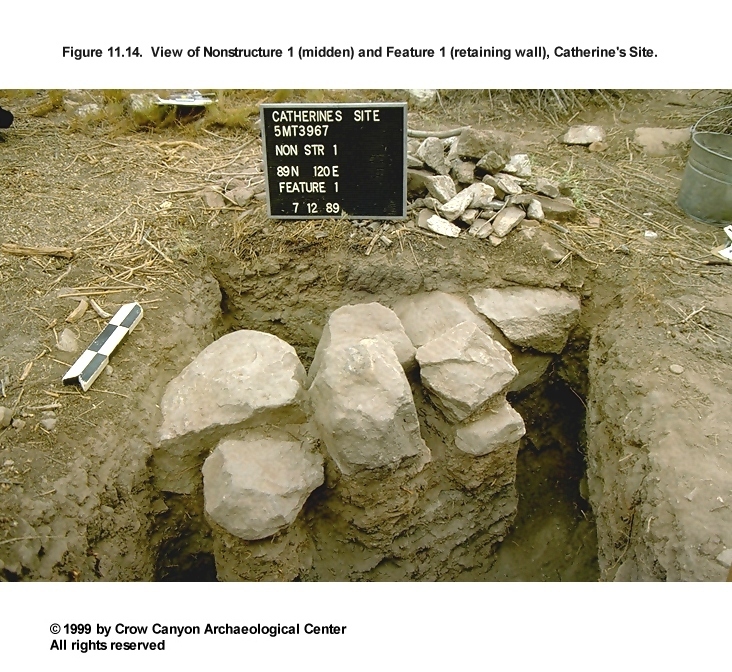
Several roughly parallel stone alignments are visible on the modern ground surface in the midden (Figure 11.3 and Figure 11.5). These retaining walls were constructed with large unmodified sandstone rocks. Figure 11.14 shows a view of Feature 1. In places, the retaining walls consist of carefully aligned stone set one next to the other. Elsewhere the stone is not as carefully placed. Poor construction or postabandonment erosion, including disturbance from grazing, may also have shifted some of the alignments.
Three long alignments are present and shorter segments appear to be present as well. Several midden sampling units uncovered portions two of these walls. These features are mentioned briefly in the description of the individual sampling units above. Feature 1 is present in sampling unit 89N/120E, and Feature 2 is present in 95N/127E, 89N/122E, and 87N/119E.
Today, the midden is a relatively level area. The location of the sterile sediment in the sampling units suggests that the prehistoric ground surface in the area of the midden had more slope, from 95.86 m to 95.17 m from west to east and from 95.58 m to 95.17 m from north to south. The retaining walls rest on top of the majority of the secondary refuse in the midden, near the modern ground surface, indicating that the retaining wall construction took place relatively late in the occupation of the site. If the walls were designed to landscape the site to create a more level ground surface, this was not attempted until the latest part of the site occupation. Instead of creating a level surface, retaining wall construction may have been designed to keep the midden deposits concentrated in a specific area of the site.
Midden Artifacts
A total of 4,314 sherds, 59.7 percent of the site total, was recovered from the midden sampling units. The majority of these sherds date to the late occupation of the site. Decorated white wares in the midden excavations that predate the Pueblo III occupation include Piedra Black-on-white (N = 1), Pueblo II White Painted (N = 6), Mancos Black-on-white (N = 11), and the Late White Painted with mineral paint (N = 22). These early sherds are found in all levels of the midden; however, they are most frequent in the lower levels.
Decorated white wares that date to the Pueblo III include Pueblo III White Painted (N = 308), McElmo Black-on-white (N = 5), Mesa Verde Black-on-white (N = 79), and the Late White Painted with carbon-paint designs (N = 459). These Pueblo III white wares were found throughout the midden, including in the lowest levels of the excavations, just above the sterile deposits at the base of the midden.
Pueblo III gray wares are also more common than earlier gray wares. There were 25 Mesa Verde Corrugated Gray sherds, no Mancos Corrugated Gray, and only one Mancos Gray sherd. Thus, the corrugated body sherds (2,366 sherds, or 54.8 percent of the sherds from the midden) probably come from Pueblo III vessels. The predominance of Pueblo III pottery in the midden indicates that the majority of all the secondary refuse in the midden comes from the Pueblo III occupation of Catherine's Site.
Seventy-one percent of the stone tools found at Catherine's Site come from the midden. Complete and fragmentary stone tools include 13 metates, 13 manos, 4 abraders, 28 peckingstones, three hammerstones, 42 cores, 10 other chipped-stone tools, two axes, two bifaces, six projectile points, one drill, six other modified stones/minerals, and 24 modified flakes. There were also 23 modified sherds, seven bone awls, 15 pieces of modified bone, three bone tubes, three pendant fragments, a piece of shell, eggshell, and gizzard stones found in the midden. In addition to these tools, 2,882 pieces of chipped-stone debris (66.4 percent of the site total) were recovered from the midden excavations.
Twelve flotation samples were collected from the midden (see Chapter 16). Charcoal from the following was identified and interpreted as fuel: juniper, pine, serviceberry/squawbush, sagebrush, cottonwood/willow, Mormon tea, mountain mahogany, bitterbrush/cliffrose, and single-leaf ash. Food remains from these flotation samples include the seeds or fruits of corn, beans, cheno-ams, prickly pear, stickleaf, winged pigweed, and a grass that could not be specifically identified. In addition, a single occurrence of a wild tobacco seed may indicate that this plant was smoked at the site. Corncobs (8-, 10-, and 12-row varieties) were also recovered from midden excavations.
Midden Interpretations
Excavation of 10 sampling units took place in the midden, and secondary refuse is present in each sampling unit. The secondary refuse contains ashy sediments, pure ash lenses, charcoal, sandstone, adobe, and numerous artifacts, including several complete or nearly complete formal tools. Several sampling units on the edges of the midden had relatively shallow deposits, especially 83N/114E and 86N/113E. Sampling units in the center of the midden encountered deep deposits of secondary refuse that began at the modern ground surface. It is possible that the top of these midden deposits eroded downslope since the site was abandoned. Roughly parallel alignments of sandstone (possible retaining walls) run through the midden. The construction of these walls on top of fill indicates that they were built relatively late in the occupation of the site. The vast majority of the midden accumulated during the post-A.D. 1200 occupation of the site.
The terms midden and secondary refuse imply that the primary use of the midden is an area to dump trash. Clearly this interpretation is correct, but the midden may have been more than just a trash dump. Prudden (1903:12) used to refer to this area of the site as the burial mound, and archaeologists working in the early half of this century routinely found many burials associated with small habitation sites (e.g., Prudden 1918:22; Roberts 1939:170, Figure 44). No burials were found in the midden sampling units at Catherine's Site, but isolated pieces of human bone are present. I believe that Prudden, almost 100 years ago, tells us why we found no burials at Catherine's Site, and why archaeologists of this generation think of this area of the site as a trash dump rather than a cemetery:
- My aims in this reconnaissance have not led me to make frequent excavations in these burial mounds, though in many instances the prospect of considerable booty in the way of pottery was excellent. I have, however, often followed closely upon the track of the professional pot-hunters and had occasion to note the large number of burials which may be discovered in a mound attached to a very small and inconspicuous ruin. . . . In earlier days the seeker for hidden treasure or for merchantable relics was wont to pull down the walls of the ruins and to delve beneath the rooms. But since the significance and constancy of the burial mounds have become generally known, the fury of the pot-hunter has been largely diverted to them. It is from these burial mounds of the open valley and mesa ruins that a large part of the pottery is derived. . . . (Prudden 1903:13-14).
Vandals had clearly disturbed the midden at Catherine's Site. There is no way of knowing the number of burials that have been removed. Our excavations demonstrate that the Catherine's Site midden has sharp boundaries and other unit pueblos that have not been altered by historic land use also show sharp boundaries. Maintaining this area as a discrete area at the site may have required some maintenance. The retaining walls may have been designed to consolidate the ashy deposits in the midden.
Middens may be more than areas where the Puebloans dumped their refuse. There may be a symbolic connection between the presence of ash and burials in the midden. Ash is important in many Pueblo myths and rituals where ash is symbolically linked to smoke, smoke to clouds, and clouds to rain. The Zuni consider clouds to represent or carry the spirit of their ancestors. Many Pueblo groups have a custom called "feeding the dead" where offerings of food and other objects are given as sustenance to their ancestors. Instead of being only a trash dump, small site middens may be cemeteries and there may be a symbolic connection between the interments, the ash, and the remainder of the refuse.
North Outer Periphery (Sampling Stratum 6)
Sampling Stratum 6 is the outer periphery sampling stratum surrounding the major cultural units on the northern end of the site. The outer periphery is an area of the site where a light artifact scatter is present, but where we did not expect to find architectural facilities and features. This sampling stratum contains 832 sampling units. Excavation took place in four of these sampling units: 101N/137E, 96N/142E, 85N/137E, and 82N/102E.
Each of the sampling units contained shallow deposits with cultural material. A single stratum was removed to reach either bedrock or sterile, pre-occupation sediments. Stratum 1 in this area is a brown sandy loam to loam. Stratum 1 has a maximum depth of 25 cm. Artifacts were most common in the upper 10 cm of each sampling unit. These artifacts may have been deposited by postabandonment erosion from the core of the site. Sampling Stratum 6 sampling units encountered no features.
Sampling Stratum 6 contained the least amount of material of any of the areas sampled at the site. Only 26 sherds, two stone tools (a core and a peckingstone), and five pieces of chipped-stone debris were recovered from the excavations in Sampling Stratum 6.
South Outer Periphery (Sampling Stratum 7)
Sampling Stratum 7 is the outer periphery on the south section of the site. A light artifact scatter defines Sampling Stratum 7. Sampling Stratum 7 is on the downslope end of Catherine's Site and artifacts are clearly moving in this direction due to postabandonment erosion. This is also an area of the site where large boulders are present. Architectural facilities and features may be present in Sampling Stratum 7; rubble and artifact concentrations are visible on the modern ground surface next to some of these boulders (Figure 11.4).
A small cottonwood tree with moss growing around its base is located south of the southernmost boulder. A rough alignment of sandstone surrounds the cottonwood and an associated artifact scatter is present. This area appears to be a spring that was present when the site was occupied. South of the spring is a series of stone alignments that may be agricultural terraces. This possible spring and the associated artifact concentration mark the south edge of the site.
Sampling Stratum 7 contains 911 sampling units. Excavation took place in four of these probabilistically located sampling units (73N/124E, 69N/115E, 67N/145E, and 65N/148E) and one judgmentally located (67N/146E) sampling unit. Excavation descriptions are presented first followed by the descriptions of Sampling Stratum 7 surface features that are mapped but not tested.
Probability Sampling Units
Sampling Units 73N/124E and 69N/115E
Excavation in these two sampling units removed a single stratum of sediment containing cultural material. Artifacts were plentiful in the upper 5 cm of sampling unit 73N/124E. These artifacts appear to be material that washed downslope from the midden since site abandonment. A line of unmodified sandstone boulders that runs along the west edge of this sampling unit might be a terrace or retaining wall, but these stones might be naturally deposited as well. Additional excavation could resolve the interpretation of these stones. Sterile sediments occur between 16 and 24 cm below the modern ground surface.
Sampling unit 69N/115E contained few artifacts. Artifacts occur in the upper 5 cm of Stratum 1. Sterile sediments lie 15 cm below the modern ground surface.
Sampling Units 67N/145E, 65N/148E, and 67N/146E
These sampling units include one judgmental and two probability test pits. A large boulder in this area of the site has a rock overhang on its south end that provides a small sheltered area (Figure 11.4). Sampling units 67N/145E and 67N/146E fall beneath this overhang and 65N/148E falls just out of the shelter.
The two probability sampling units have similar stratigraphy consisting of an upper stratum of yellow brown sand (Stratum 1) and a lower stratum of dark brown to black charcoal-stained sediment (Stratum 2). Stratum 1 is 6 to 10 cm thick in sampling unit 67N/145E. Stratum 1 hit bedrock in the northwest half of 65N/148E. Stratum 2 in the southeast half was a maximum of 16 cm thick. Excavation uncovered bedrock 2 to 5 cm below the surface in all but the northwest corner of sampling unit 65N/148E. A dark brown to black charcoal-stained sediment continued down 22 cm below the modern ground surface in the northwest corner. The dark sediment is refuse from the hearth found in 67N/146E.
Feature 1 (Hearth). The northwest quarter of a hearth is present in the judgmentally located test pit 67N/146E. This is a slab- and bedrock-lined hearth beneath the boulder overhang. Hearth construction included chipping a pit into the bedrock and lining a portion of the pit with upright sandstone slabs. The portion of the hearth exposed in the test pit measures 72 by 67 cm and is 49 cm deep.
Stratum 1 deposits cover the hearth. Several strata fill the hearth. Stratum 1 is an ashy, gray brown sandy sediment; charred corn, wood charcoal, and small sandstone gravels are present as inclusions. This stratum covers the top of the hearth and spills out into the area surrounding the pit itself. Stratum 1 is 17 cm thick outside the hearth and 28 cm thick within the pit. Stratum 2 of the hearth fill lies entirely within the center of the pit. Stratum 2 is 26 to 32 cm thick and extends down to the bedrock base of the hearth. Stratum 3 and 4 make up the remainder of the hearth fill. These strata lie on either side of Stratum 2 against the walls of the hearth.
Stratum 2 is a layer of dark gray ash. Three charcoal beams that range between 10 and 20 cm diameter and several smaller pieces of charcoal are present in Stratum 2. Large pieces of burned sandstone are present in Stratum 2 also. Stratum 3 is a pocket of red brown sand with no charcoal. Stratum 4 is a pocket of dark red gray sand with some ash and charcoal. Stratum 3 and 4 are evidence that this hearth was used and cleaned repeatedly.
The presence of corn in the hearth fill indicates that the feature was probably used for food preparation. The large wood specimens from Stratum 2 are fuel from the last use of the feature. This feature may have been used as a roasting pit, and Stratum 1 may have been placed in the feature to smother the fire as a part of this roasting activity. It is not clear if this hearth was used during the Pueblo III occupation of Catherine's Site. Organic-paint pottery, including both McElmo and Mesa Verde black-on-white, is present in the area around the overhang. Mineral-paint black-on-white pottery is also present, but it is not as common as the organic-paint pottery. It is possible that this feature is part of an earlier (that is, Pueblo II) limited use (for example, a field shelter) of Catherine's Site and that the feature was reused during the Pueblo III period. Alternatively, the feature may date to the Pueblo III period, with the earlier pottery fortuitously mixed in the fill. Unfortunately, the tree-ring samples did not produce dates.
The Spring and Agricultural Terraces
A small cottonwood tree is growing on the south edge of the site. The cottonwood is small and may have been alive no more than 40 years. It is growing in the middle of a prehistoric feature. A cluster of water-worn sandstone surrounds the cottonwood. This sandstone perimeter measures approximately 4 m in diameter. This sandstone may have formed a crude wall around a spring (Figure 11.3 and Figure 11.15).
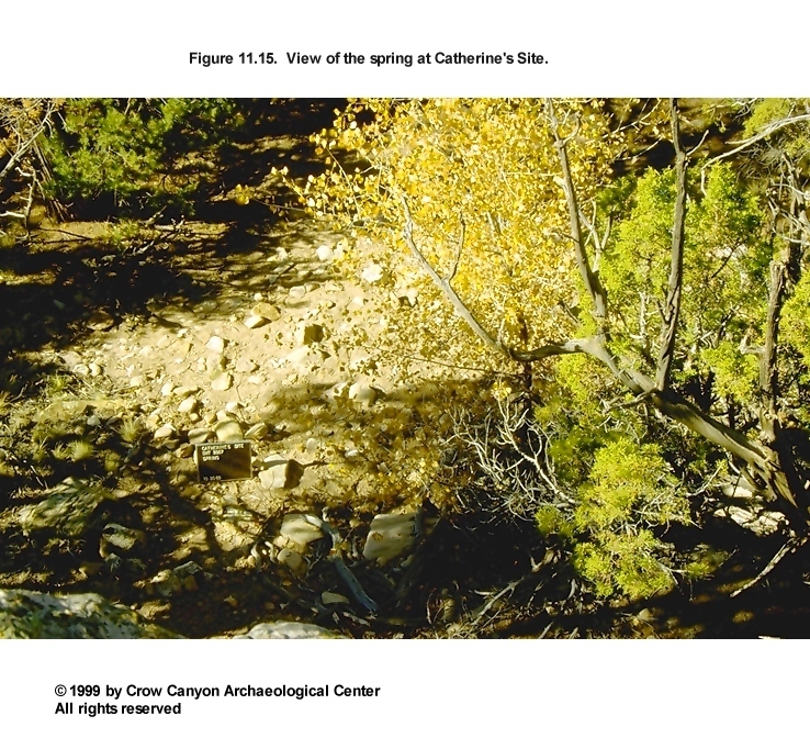
An artifact scatter is associated with this area. A noncollection surface tally indicates that white ware jar sherds (N = 8), corrugated jar sherds (N = 5), unpainted white ware bowl sherds (N = 2), organic-paint black-on-white bowl sherds (N = 2), a ladle sherd (N = 1), and five pieces of chipped-stone debris are part of this artifact cluster.
Downslope from this possible spring is a series of stone alignments that run perpendicular to the drainage that defines the east edge of Catherine's Site. These stone alignments begin 7 m south of the spring. There are four alignments spaced at intervals of 4, 2, and 6 m. These alignments are interpreted as agricultural features. Sediment would have accumulated behind them, and the deeper soil would have helped to conserve moisture. This area may have been irrigated from the spring or by floodwater from the drainage on the east side of the site.
Similar stone alignments lie 30 m east of the possible spring and 35 m north of the spring (Figure 11.16). These stone alignments are just beyond the limits of the Catherine's Site artifact scatter. The soils on the bench where Catherine's Site is located are not classified as productive agricultural soils today, but the presence of these agricultural features suggests that they were farmed by the Puebloans.
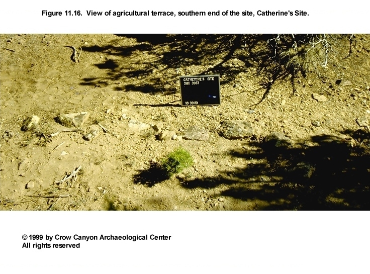
South Outer Periphery Summary and Interpretations
Activity areas are present in this area of the site. Two noted during testing are centered around a hearth under a rock overhang and a possible spring and associated agricultural features. This sampling stratum is on the downslope side of the site. Artifact density in this part of the site is relatively light. The artifacts found in this sampling stratum could have been deposited as a part of the activities that took place at the site, or by downslope, postabandonment erosion. A total of 87 sherds, one biface, and 78 pieces of chipped-stone debris were recovered from the Sampling Stratum 7 units. Only two sherds, typed as Late White Painted, have mineral-paint designs; the remaining decorated white wares (N = 26) from Sampling Stratum 7 have organic-paint designs, indicating that they are probably from Pueblo III vessels.
Catherine's Site Artifacts
More artifacts were recovered from Catherine's Site than from any other tested site except Castle Rock Pueblo and Kenzie Dawn Hamlet. These artifacts are reported in tables at the end of this chapter (Table 11.1, Table 11.2, Table 11.3, Table 11.4, and Table 11.5). A total of 7,221 sherds was recovered from the site. Early (pre-Pueblo III) pottery is relatively scarce. Early decorated white wares include Piedra Black-on-white (N = 1), Early White Painted (N = 5), Cortez Black-on-white (N = 2), Pueblo II White Painted (N = 19), Mancos Black-on-white (N = 15), and probably the Late White Painted sherds with mineral paint (N = 60). Late (Pueblo III) pottery is much more plentiful. This includes Pueblo III White Painted (N = 411), McElmo Black-on-white (N = 6), Mesa Verde Black-on-white (N = 104), and probably the Late White Painted with mineral-paint sherds (N = 781).
Gray wares are similar to white wares; some earlier pottery is present, but the majority of the gray ware sherds that can be assigned a specific type are Pueblo III. Early gray wares include Mancos Gray (N = 1), Mancos Corrugated Gray (N = 1), and Indeterminate Plain Gray (N = 36). Mesa Verde Corrugated is the gray ware type that can be most confidently assigned a Pueblo III date, and these sherds were more common than the earlier gray ware sherds (N = 26). Corrugated body sherds are the most common type of pottery found on the site, numbering 4,115 sherds, or 57 percent of the site total. Given the fact that Mesa Verde Corrugated Gray rim sherds outnumber Mancos Corrugated Gray rim sherds 26 to 1, the majority of these corrugated gray ware body sherds probably come from Pueblo III vessels (see also Chapter 15).
The early decorated white wares and gray wares are scarce, but they probably indicate that there was use of the site before the Pueblo III period. The low numbers of early material suggest that this was a limited-use occupation (for example, a field house) rather than use of the site as a habitation. There may have been both Pueblo I and Pueblo II limited use of Catherine's Site. The predominance of Pueblo III gray wares and decorated white wares, however, indicates that the majority of the refuse deposited at Catherine's Site dates to the Pueblo III occupation.
Complete and fragmentary tools recovered from the site include 22 metates, 18 manos, four abraders, five hammerstones, 33 peckingstones, 57 cores, two axes, four bifaces, seven projectile points, four drills, 14 other chipped-stone tools, 13 other modified stone/minerals, seven bone awls, 31 modified flakes, 35 modified sherds, and 19 pieces of modified bone. A bone bead, a stone bead, four bone tube fragments, four pendant fragments, eggshell, gizzard stones, and a shell fragment were also recovered. A total of 4,334 pieces of chipped-stone debris was also found.
Like all of the tested sites, nonlocal material is relatively scarce. San Juan Red Ware includes one Bluff Black-on-red sherd, one Deadmans Black-on-red, and four San Juan Red Ware body sherds. A single piece of nonlocal painted red ware was found and identified as a Puerco Black-on-red. Out of 220 stone tools, only seven items (3.2 percent) were made of from nonlocal material. Chipped-stone nonlocal material includes 30 pieces of agate/chalcedony, 23 pieces of nonlocal chert/siltstone, one piece of Washington Pass chert, and six pieces of unidentifiable nonlocal chipped stone; this nonlocal material is 1.4 percent of the total chipped-stone debris. The relative scarcity of nonlocal materials found at Catherine's Site indicates that the inhabitants were not well integrated into regional exchange networks.
Catherine's Site Conclusions and Interpretations
Catherine's Site is a small habitation located on a terrace within Sand Canyon, 1.4 km down-canyon from Sand Canyon Pueblo. Excavation took place in 41 randomly selected sampling units and six judgmentally located sampling units. These excavations documented that the primary occupation of Catherine's Site dates to the A.D. 1200s and that the site was used as a year-round habitation during that period. Architectural facilities that date to the Pueblo III occupation include two pit structures, at least one of which has masonry-lined walls (the walls of the other pit structure were not observed). A masonry roomblock with at least four rooms was outlined, and nonmasonry rooms could be present as well. Associated with these architectural features is a large and deep midden. The types of pottery recovered from Catherine's suggest that the site may have been used on a limited basis before the Pueblo III period. Earlier use may have included both Pueblo I and Pueblo II occupation of the site.
Structure 1 is a masonry-lined pit structure, or kiva, that has a single prepared adobe floor. The walls of Structure 2 were not exposed during testing, so the wall construction materials are unknown. However, three (possibly four) floors were documented in Structure 2. A small bell-shaped cist is associated with an early surface. An extensively remodeled hearth was also found. The results of archaeomagnetic dating indicate that the hearth was used sometime after A.D. 1200. Structure 2 may have been the first pit structure constructed during the Pueblo III occupation at Catherine's Site, and Structure 1 may have been added to accommodate growth at the site. The Catherine's Site midden was almost 1 m deep in places, an indication that the site was occupied for a substantial amount of time.
Roof timbers from both pit structures were salvaged when the structures were abandoned. Thick cultural deposits cover both floors. These deposits may be unburned roof fall that fell to the floor as the roof timbers were being salvaged. Roomblock rubble was thrown into the Structure 2 depression as well. Some of the rooms apparently were dismantled at the same time that the pit structures were abandoned. The salvaging of roof timbers from the structures at Catherine's Site suggests that the move to the next site was a short distance, which in turn indicates that Catherine's was abandoned before the abandonment of the region as a whole. Abandonment of the Sand Canyon locality is believed to have occurred between A.D. 1280 and 1300, because the latest tree-ring dates from the Sand Canyon Project date to the late A.D. 1270s. Thus, the structures from which roof timbers were salvaged were probably abandoned before A.D. 1275.
The archaeomagnetic date from the Structure 2 hearth is A.D. 1200-1325. The Catherine's Site pottery assemblage contains more Mesa Verde Black-on-white than do the assemblages from the mesa-top sites which are dated to the early A.D. 1200s. Together, the archaeomagnetic date, the high percentage of Mesa Verde Black-on-white pottery, and the stratigraphy in Structures 1 and 2 suggest that the main period of occupation of Catherine's Site dates to the middle A.D. 1200s, that is, A.D. 1240 to 1270. This date range is similar to that of the Green Lizard site, which is located in a setting similar to that of Catherine's. The Catherine's Site occupation is probably partly contemporaneous with the occupations of the talus-slope sites, the lower Sand Canyon sites, and Sand Canyon Pueblo.
Pottery, architecture, and stratigraphy suggest a potentially complex occupational history for the site. A limited amount of Pueblo I and II pottery is present. The small amount of pottery and the absence of any architectural facilities that clearly date to the Pueblo I and II periods indicates that this early use of the site was probably seasonal and limited.
As noted above, the architectural units and midden suggest that there was year-round occupation in the middle A.D. 1200s. Stratigraphy in three sampling units (105N/124E, 101N/124E, and 99N/124E) shows alternating natural and cultural deposits, which may indicate that there were periods of abandonment and reoccupation during this late Pueblo III occupation. One possibility is that Catherine's Site continued in limited use after it was abandoned as a year-round habitation. Support for this scenario is found in the roomblock. Most of the roomblock walls stand only one or two courses high. However, a room at the north end of the roomblock has walls that stand over 1 m high. The tops of the walls of this room have been exposed by vandals, and rubble appears to completely fill the room. Possibly, this room was left standing after other areas of the site had been abandoned and the roof timbers salvaged. This intact room may have been used as a field house, for example, until the abandonment of the Sand Canyon locality at approximately A.D. 1290.
The presence of a possible spring and agricultural features on and near the site indicate that farming took place near Catherine's Site. The agricultural features may mark the locations of either small gardens or the primary fields used by the inhabitants of the site. Use of the spring may explain the long and complex history of occupation at the site.