9
Lookout House
Kristin A. Kuckelman
Contents
- Surface Architecture (Sampling Stratum 1)
- Nonstructure 2 (Midden)
Structure 8 (Tower)
Sampling Unit 100N/115E - Feature 1 (Burned Spot)
Feature 2 (Retaining Wall) - Other Wall
Surface Architecture (Sampling Stratum 1) Summary
- Pit Structures (Sampling Stratum 2)
- Structure 1 (Kiva)
- Surface 1
- Features
- Feature 1 (Retaining Wall)
Feature 2 (Ventilator System)
Feature 3 (Deflector)
Feature 4 (Hearth) - Artifacts
- Stratigraphy
Dating
Interpretations - Structure 2 (Kiva)
- Surface 1
- Features
- Feature 1 (Bench 5)
Feature 2 (Pilaster 5)
Feature 3 (Pilaster 6)
Feature 4 (Pilaster 3)
Feature 5 (Bench 3)
Feature 6 (Niche)
Feature 7 (Burial)
Feature 8 (Burial) - Artifacts
- Stratigraphy
Dating
Interpretations - Pit Structures (Sampling Stratum 2) Summary
- Courtyard (Sampling Stratum 3)
- Sampling Unit 97N/100E
- Stratigraphy
Feature 1 (Burned Spot)
Feature 2 (Burned Spot)
Feature 5 (Wall) - Courtyard (Sampling Stratum 3) Summary
- Inner Periphery (Sampling Stratum 4)
- Inner Periphery (Sampling Stratum 4) Summary
Outer Periphery (Sampling Strata 6, 7, and 9)
Outer Periphery (Sampling Stratum 8)
Introduction
Lookout House (5MT10459) was recorded in 1987 as site CC87-286 during a cultural resources reconnaissance by a Crow Canyon crew (Adler 1988). In 1989, the site was selected to be tested as part of Crow Canyon's Sand Canyon Site Testing Program. Testing began during the 1990 field season and was completed during the 1991 field season. Excavations were directed by Mark D. Varien and Kristin A. Kuckelman.
Lookout House was selected for testing because it seemed likely that excavation would produce data useful in answering the research questions posed by the Site Testing Program. The Site Testing Program was initiated in an attempt to characterize the community surrounding Sand Canyon Pueblo during the occupation of that large site. Thus, the small sites selected for testing were, first, those that appeared to be contemporaneous with Sand Canyon Pueblo on the basis of pottery observed on the modern ground surface. Second, sites with a substantial amount of architecture were good candidates for testing because structures are the most likely proveniences to yield tree-ring samples. Tree-ring dates are necessary to confirm occupational contemporaneity with Sand Canyon Pueblo. Third, sites in a variety of topographic settings were tested in order to determine whether site location is function-dependent or time-dependent. As a talus site, Lookout House added to the topographic variety of the sample. For additional discussion of the research objectives of the Site Testing Program, refer to Chapter 1 of this volume.
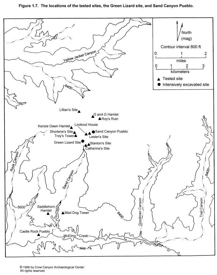
Lookout House is located below the north rim of Sand Canyon, 675 m west of the canyon head, in Montezuma County, southwestern Colorado (Figure 1.7). This site is 100 m west along the canyon rim from Lester's Site (Chapter 8) and approximately 150 m southwest of Sand Canyon Pueblo. Most of the architecture at Lookout House is on a narrow, sloping terrace; the midden is on the talus slope below the terrace. The elevation of the site ranges from 2066 m (6780 ft) at the terrace to 2042 m (6700 ft) at the southernmost edge of the downslope artifact scatter. The slope of the site varies between 3 degrees on the most level area of the architecture terrace to 35 degrees on the steepest portion of the talus slope. The nearest permanent water source during the occupation of the site was the spring at Sand Canyon Pueblo, 275 m to the northeast.
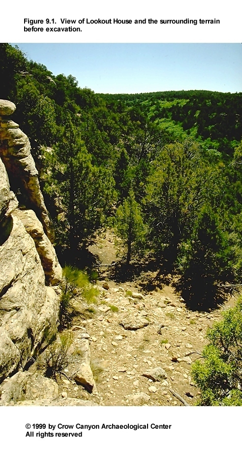
The primary vegetation on the site is pinyon-juniper (Figure 9.1). Also noted were Mormon tea (Ephedra viridis), sagebrush (Artemisia tridentata), prickly pear (Opuntia sp.), wolfberry (Lycium pallidum), and grasses.
Historic use of the site has been naturally limited by its location in the canyon and by the steep, rugged terrain. No evidence of illegal excavation was observed, but the proximity of highly visible Sand Canyon Pueblo has undoubtedly resulted in looting. Also, artifacts were being collected illegally from the modern ground surface on weekends during the course of our excavations.
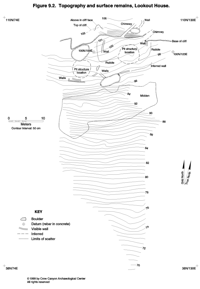
Surface remains that are relatively easy to interpret on mesa tops or other level terrain are masked by substantial sediment accumulation and by naturally occurring boulders and rubble on talus sites. Surface remains observed at Lookout House include two pit structure areas, sections of the main site retaining wall, dense and light rubble in the areas surrounding the pit structures, a natural alcove in the sandstone face at the north edge of the site, a stained midden, and sparse remnants of a masonry structure located on a sandstone outcrop above the site (Figure 9.2). This masonry structure is believed to have been a tower because of its isolated location above the remainder of the site. The site was named for this structure.
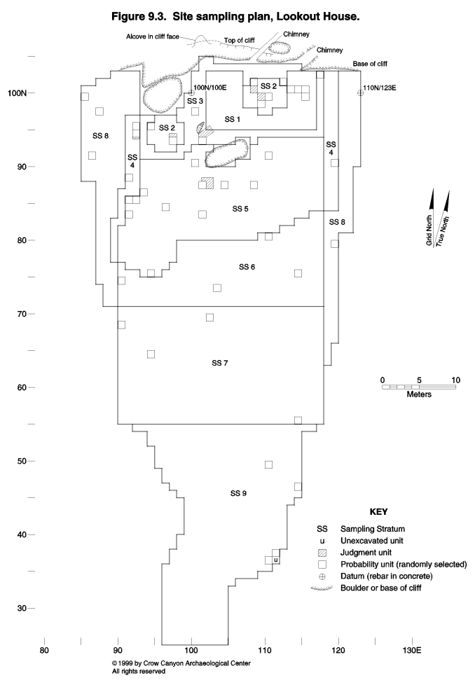
Remains observable on the modern ground surface were used to define sampling strata for stratified random sample testing (Figure 9.3). Areas of rubble that appeared to be the result of collapsed surface structures (rather than retaining walls) were designated Sampling Stratum 1. The masonry structure on the sandstone outcrop was not included in the sampling plan, because no cultural deposits survived on the slickrock. Sampling Stratum 2 was defined by the two pit structure areas. These areas have little or no sandstone rubble and are located in areas where the terrace is slightly wider and more level. Sampling Stratum 3 is the courtyard, which is the area immediately surrounding the architecture; the outer limits of this unit roughly correspond to the main site retaining wall.
Sampling Stratum 4 is defined as the inner periphery, which includes narrow strips that border the other cultural units at the site. The midden is Sampling Stratum 5. Sampling Strata 6, 7, and 9 are outer periphery strata. Data from testing these areas will aid in characterizing the amount and type of downslope (southward) movement of artifacts on the site. Sampling Stratum 8 covers the east and west limits of the artifact scatter.
The site area as defined encompasses 1,997 m². Testing consisted primarily of excavation in 45 randomly selected 1-×-1-m units. A limited amount of judgmental excavation also occurred: a strip 1 m long and 25 cm wide was excavated south of unit 94N/92E for logistical reasons (see Room 4 discussion); an L-shaped area north and east of unit 87N/101E was opened to expose the remainder of a burial; an irregularly shaped trench was excavated northeast of unit 93N/101E in order to define the nature and function of a masonry wall; a unit 1 m long and 50 cm wide was excavated north of unit 93N/97E (Structure 1) to expose the kiva hearth; and 1-×-1-m units 99N/109E and 100N/108E were opened in Structure 2 (kiva) for logistical reasons and to expose the kiva hearth, respectively. Due to time constraints, the two judgmentally located units in Structure 2 were not excavated to the floor.
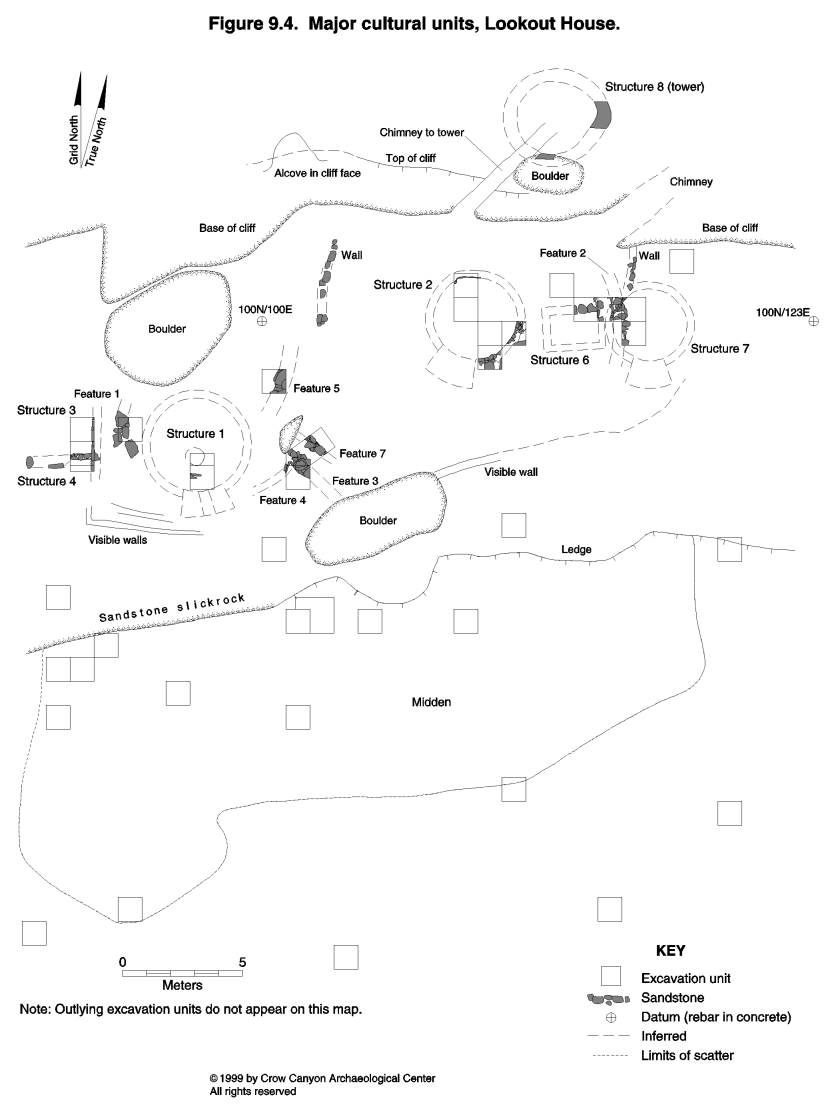
Test excavations resulted in the definition of several major cultural units (Figure 9.4) at Lookout House. Three kivas, two masonry surface rooms, one subterranean masonry-lined room, two midden areas (one inside Structure 7), and various sections of retaining walls were located during testing. All architecture at the site appears to date to one occupation that occurred in the middle to late A.D. 1200s. The amount and type of architecture and the extent of the midden deposits suggest that Lookout House functioned as a year-round habitation.
The site grid is oriented to the canyon rim and to the slope of the site. Grid north is 29 degrees west of magnetic north, or 15.5 degrees west of true north. Datums consisting of rebar set in concrete mark the grid points 100N/100E and 100N/123E. The 100N/100E datum is also the primary vertical datum; the top of this rebar was arbitrarily designated 100 m elevation.
This chapter is organized by sampling stratum in numerical order. Each sampling stratum section contains descriptions of the cultural units (kivas, masonry rooms, and midden areas) found in that stratum; the cultural units are also presented in numerical order.
Surface Architecture (Sampling Stratum 1)
Sampling Stratum 1 is the surface architecture sampling stratum. This stratum was designed to sample all areas of rubble that were interpreted to have originated from the collapse of surface rooms. Eighty-eight square meters of area were assigned to this sampling stratum. Excavation of four randomly selected units (99N/115E, 100N/113E, 100N/114E, and 100N/115E) led to the definition of one subterranean, masonry-lined room (Structure 6), one kiva (Structure 7), one burned feature (Feature 1), one section of retaining wall (Feature 2), and a midden area (Nonstructure 2). No judgmental units were excavated in this sampling stratum, although the top of a short section of masonry wall was exposed in order to determine that surface rooms are present in this sampling stratum (Figure 9.4). Also, Structure 8 (tower) is not technically within any sampling stratum and therefore was not tested, but it is within the site boundaries (Figure 9.2) and will be briefly described in this section.
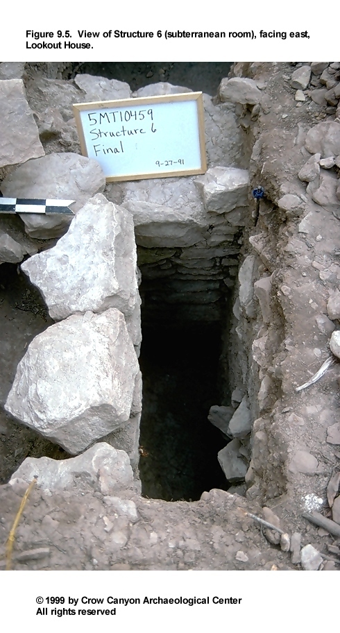
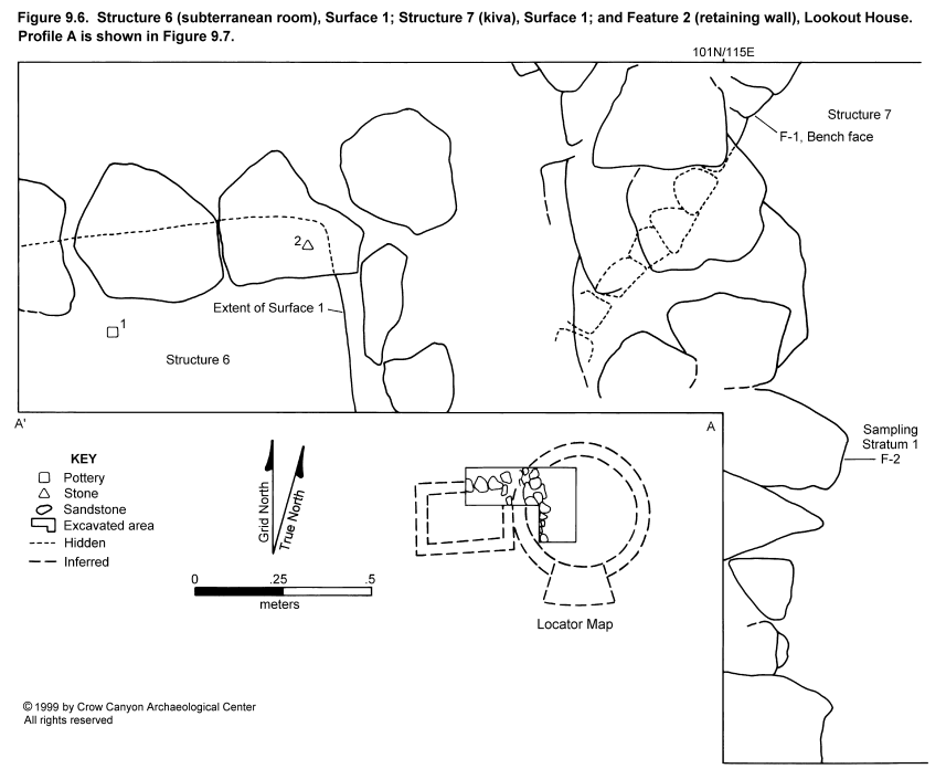
Structure 6 (Subterranean Room)
Structure 6 is a masonry-lined, rectangular, subterranean structure (Figure 9.5 and Figure 9.6). Only the northeast corner of this room was excavated; this portion of the structure was exposed in unit 100N/113E.
Construction
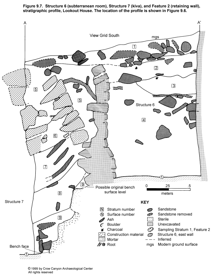
The architectural construction observed in Structure 6 is described in this section, including the walls, roof, and floor (Figure 9.6 and Figure 9.7).
Walls. Excavation in Structure 6 exposed portions of the north and east walls. Both walls are semicoursed and are a single stone wide. The exposed section of north wall measures 1 m long at prehistoric ground surface and 87 cm long at the floor surface. The wall extends 1.49 m below prehistoric ground surface and contains 11 vertical courses. The width of the wall at prehistoric ground surface is 36 cm; this course appears to be wider than the courses below it (30 cm) and so may have served to cap the wall, achieving greater structural stability. The north wall is abutted to the east wall of the structure. The west half of the north wall rests on a foundation of sandstone bedrock, and the east half rests on sterile gray clay.
Approximately one-half of the rocks in the north wall have been shaped by flaking, a few have been pecked, and the remainder are unshaped. Forty percent of the rocks are tabular, 45 percent are irregular, and 15 percent are block. One-half of the chinking stones in this wall are tabular; the remainder are chunks.
The mortar is a light brownish gray, fine-grained silt loam with numerous inclusions of calcium carbonate, sandstone and shale bits, unburned adobe nodules, and charcoal flecks. The mortar joints are flush and measure up to 7 cm wide and 4 cm thick.
The exposed section of east wall measures 45 cm long at modern ground surface and 52 cm long at the floor surface. The 11 vertical courses extend 1.33 m below prehistoric ground surface (Figure 9.7). The east wall is 22 cm thick and does not have the capping stones noted at the top of the north wall. The east wall is abutted by the north wall.
Approximately 85 percent of the observable portion of this wall is constructed of unshaped sandstone, and 15 percent appears to be shaped by flaking. Fifty-five percent of the stones are tabular, and the remainder are irregular. The east wall rests on a foundation of sterile gray clay.
The mortar is the same as that described for the north wall, except the joints are up to 2.5 cm wide and 7 cm thick. The chinking observed is 80 percent chunks of sandstone and 20 percent tabular pieces.
Roof. Little is known of the roofing construction for Structure 6. There is no evidence that the roof burned, and no vegetal material from the roof was preserved in the structure fill. The absence of roofing beams suggests that these may have been salvaged for later use elsewhere.
The sediment component of the roof was observed in the lower fill in the excavated portion of the structure. This material consisted of jumbled, redeposited sterile, that is, silt loam with sandstone bits, small rocks, and numerous shale bits and nodules of gray clay and calcium carbonate. This was probably material mined during the original excavation of this structure. No post holes were observed in the floor; thus, the roof presumably was supported by the walls.
Surface 1. Surface 1 is the floor of Structure 6. It is constructed of undisturbed sterile sediment consisting of brown silt loam with abundant gray clay nodules and sandstone and shale bits. The surface is relatively level but slopes down a few centimeters at the east wall and in the northeast corner, and slopes up a few centimeters at the west end of the north wall, where the surface is formed of sandstone bedrock. A thin layer of dark brown organic material of unknown origin was noted on the floor surface.
Surface 1
An area of floor measuring 55 cm north-south by 95 cm east-west was exposed in the northeast corner of Structure 6. No features were defined on this surface. Only one artifact was found in direct contact with the floor--a large core of Morrison quartzite. One Pueblo III White Painted sherd was point-located 3.5 cm above the floor and may be associated with the use of the structure.
Stratigraphy
The fill in Structure 6 is illustrated in Figure 9.7. This stratigraphy was difficult to observe, and thus to map and interpret, because of the extremely restricted space and the resulting poor lighting. The observed stratigraphy is described from the modern ground surface down to Surface 1.
Stratum 1 is a yellowish brown loam containing numerous inclusions of sandstone (from tiny bits up to rocks measuring 10 × 15 cm), some pockets of calcium carbonate flecks, and small bits of gray shale interspersed throughout the deposit. The boundary of Stratum 1 with Stratum 2 is abrupt and smooth.
Stratum 1 is the most recent deposit in the profile. It extends outside Structure 6, and so was deposited after the structure was completely filled. The stratum is a combination of colluvial, alluvial, and aeolian deposits. The sandstone in this stratum appears to be unmodified talus.
Stratum 2 is a grayish brown silt loam with numerous calcium carbonate flecks, a few charcoal pieces, sandstone rocks similar in size (but far fewer in number) to those in Stratum 1, unburned adobe nodules, and numerous shale bits. The boundary between Stratum 2 and Stratum 3 is abrupt and wavy.
Stratum 2 is a postoccupational deposit that appears, considering color and inclusions, to be transitional between Stratum 1 and Stratum 3. This material was deposited naturally after the walls of Structure 6 had ceased collapsing. The origin of the adobe nodules in this stratum is unclear.
Stratum 3 is a gray silt loam with abundant inclusions of decomposing shale and calcium carbonate and a high gray clay content; also present are small, sparse charcoal flecks, small sandstone bits, and small, unburned adobe nodules. The boundary of Stratum 3 with Stratum 4 is clear and smooth.
Stratum 3 is a natural, postoccupational deposit. Although Stratum 3 contains much smaller inclusions than does Stratum 4, both deposits contain material that looked like construction fill (jumbled, redeposited sterile). Stratum 3 may be a deposit of roof-associated materials from prehistoric ground surface around the perimeter of Structure 6.
Stratum 4 might have been subdivided into additional strata had the lighting and visibility been better. The stratum as observed consists of a grayish brown silt loam containing so many inclusions that the sediment texture was difficult to assess. The many pieces of sandstone range in size from small bits up to wall-fall size (see Figure 9.7). Pieces of gray shale up to 1 cm long are plentiful, as are gray clay nodules up to 3 cm in diameter. The size and number of gray clay nodules increases with proximity to the structure floor. Calcium carbonate flecks are also abundant. Charcoal is present but sparse; unburned adobe is also present. The boundary of Stratum 4 with the Structure 6 floor is abrupt and smooth.
Stratum 4 appears homogeneous and massive and probably consists of construction debris from this structure, that is, roof fall (minus vegetal material) and roof fall mixed with wall fall higher up the profile. The composition of this stratum is very similar to the horizon of undisturbed sterile that forms the floor of the structure, leading to the assumption that the sediment portion of the roof was constructed with the sterile material mined during the excavation of the pit that was to become Structure 6.
The absence of vegetal remnants in Stratum 4 indicates that the timbers were salvaged for reuse elsewhere. The position of this roofing material directly on the floor suggests that the roof was intentionally dismantled when the structure was abandoned, before wind- and water-deposited sediments could accumulate on the floor.
Few artifacts were recovered from the fill of Structure 6. Pueblo III White Painted sherds (N = 4), Late White Unpainted sherds (N = 3), Indeterminate corrugated sherds (N = 4), and chipped-stone debris (N = 3) were the only artifacts recovered from this fill.
Dating
No tree-ring or archaeomagnetic samples are available to date Structure 6. The architectural style is consistent with that observed in other structures on the site (semicoursed masonry; tabular, block, and irregular sandstone; some shaping by flaking and pecking), as is the Pueblo III pottery assemblage associated with the structure. Thus, there is no evidence to suggest that Structure 6 is not contemporaneous with the other architecture at Lookout House.
Interpretations
Structure 6 is an unburned, subterranean, masonry-lined rectangular room of unknown function. Structure function was difficult to determine from such a small test pit. Proximity to Structures 2 and 7 (kivas) may indicate that Structure 6 is functionally associated with one or both of these structures. Other Pueblo III rectangular, subterranean, masonry-lined rooms have been associated with nearby kivas (Jeannette Mobley-Tanaka, personal communication 1991; Morris 1991a:81-88, 444-458). Some of these structures are clearly mealing rooms (Morris 1991a:81-88, 444-458). Others provided no clues as to their functions, such as the room at Yellow Jacket's 5MT3 that is connected by a tunnel to a kiva.
Because such a small area of Structure 6 was excavated, it is impossible to state if this room contains mealing apparatus or if it is connected by tunnel to Structures 2 and/or 7. Structure 7, a kiva, was partly dismantled and filled with trash during the occupation of the site, whereas Structure 2, also a kiva, filled naturally. Thus, Structure 6 could have been originally associated with Structure 7, then associated with Structure 2 after the abandonment of Structure 7.
Structure 7 (Kiva)
Structure 7 is the remains of an unburned, partly dismantled, trash-filled kiva (Figure 9.6 and Figure 9.8). A small area in the western half of the structure was excavated; test unit 99N/115E is entirely within the structure, the northwest corner of unit 100N/115E encountered the bench face, and the southeast corner of 100N/114E exposed additional bench face. The extrapolated diameter of the structure is approximately 3.15 m, bench face to bench face.
Construction
The architectural construction of Structure 7 is described in this section, including the walls, roof, and floor.
Walls. The kiva walls had been partly dismantled in this structure. The wall construction observed consisted of a section of partly intact bench (Figure 9.6, Figure 9.7, and Figure 9.8), which is described under the Feature 1 heading below.
Roof. There is no direct evidence of the roof construction for Structure 7. However, indirect evidence of the Structure 7 roof consisted of numerous sandstone blocks pecked to form right angles. Although these blocks were found in the fill, they are assumed to have once formed roof-supporting pilasters on the structure bench. A stratum of roof fall material on the floor surface (Figure 9.7) indicates that the structure was completed, used, and then dismantled, rather than being abandoned before completion. Because this roof fall deposit did not have a vegetal component, it is assumed that the beams were salvaged for reuse elsewhere on the site.
Surface 1. Surface 1 is the floor of Structure 7. Most of the exposed surface is formed of reddish brown adobe; however, in the southwest corner of unit 99N/115E, shale bedrock formed the floor surface. This bedrock might have been covered with adobe originally. Also noted were areas of darker orange/brown adobe that appear to be floor patches or repairs.
Coating the floor was a gray residue that appeared to be ash. This film might have resulted from use of the kiva or from ash leaching down from the midden deposits in the fill above roof fall. The adobe surface was not removed, due to time constraints. Thus, the characteristics of the sterile deposits beneath the adobe are unknown, but they are probably similar to those of the undisturbed material at the base of the bench (gray clay with sandstone and shale inclusions).
Surface 1
Surface 1 is the floor in Structure 7. An irregular area of floor totaling approximately 2.15 m² was exposed. No artifacts were found directly on the floor; one modified flake was recovered from a few centimeters above the floor. One feature, a bench, was documented.
Feature 1 (Bench). Only a 1.09-m section of bench within units 100N/114E and 100N/115E was exposed. This bench is very poorly preserved (Figure 9.8), which is believed to be the result of intentional dismantling during the occupation of the site.
The highest extant section of bench face is 38 cm high (six vertical courses), which is at the north end of the exposed section of bench. At the south end, the remaining face is only 7 cm high (one course). The masonry is a single stone wide, measuring 10 to 12 cm thick. Seventy-five percent of the rocks were pecked, and 25 percent were unshaped. Forty percent of the stones are blocky, 20 percent are tabular, and 40 percent are irregular. No chinking was observed in the extant portion of the bench face. The bench rests on a foundation of undisturbed sterile clay.
The mortar observed is a fine-textured gray clay containing bits of sandstone and calcium carbonate and charcoal flecks. The mortar beds are extruded and are 2 to 3 cm wide and 1 to 2 cm thick. No plaster was noted.
No horizontal bench surface survives. Construction material fills the space between the bench face and undisturbed sterile deposits. This fill consists of redeposited sterile sediment with a few charcoal flecks, small adobe nodules, and occasional artifacts. Thus, this kiva appears to have been constructed in the standard manner. First, a pit was excavated slightly larger in diameter than that of the finished structure. Then the masonry of the bench face was constructed as a freestanding wall, and construction fill was added behind it up to the horizontal bench surface.
The bench face is believed to have been dismantled rather than to have collapsed naturally because kiva benches are generally very well preserved, and this bench is almost totally demolished. Also, the lower fill of the structure does not contain enough stones to account for the entire bench face, so the stones must have been removed.
Stratigraphy
The fill in Structure 7, shown in Figure 9.7, consists of postabandonment deposits, construction material, midden, and Structure 7 roof fall. This fill is described from the top of the fill down.
Stratum 5 is a light yellowish brown loam containing abundant inclusions: sandstone rocks from bits up to building-stone size; numerous pockets of gray clay, gray shale bits and chunks, unburned adobe nodules, and calcium carbonate flecks; and a few artifacts and pieces of charcoal. The boundary of this stratum with Stratum 6 is clear and smooth.
Stratum 5 is culturally deposited construction fill/mortar that was placed between the two horizontal courses of Feature 2 (retaining wall) and between Feature 2 and the outside face of the east wall of Structure 6. This fill is similar to roof fall (Stratum 8) except that roof fall is slightly more orange, possibly due to the increased adobe content.
Stratum 6 consists of a grayish brown sediment that, like Stratum 7, is predominantly ash; it contains inclusions of sandstone (from bits up to just smaller than fist size) and sparse charcoal flecks. The boundary with Stratum 7 is clear and smooth. This stratum was observed only between the rocks in the bottom two to three courses of Feature 2, the retaining wall (see discussion of Feature 2 under sampling unit 100N/115E), and it apparently resulted from the lowermost courses of this wall settling into the midden ash during and after the construction of the wall. Like Stratum 7, this stratum is provenienced Nonstructure 2 (midden).
Stratum 7 varies from gray to light brownish gray. The sediment is ash and silty ash with numerous charcoal pieces, sparse lumps of unburned adobe, small sandstone bits, numerous fist-size rocks, a few rocks up to building-stone size, burned corncobs, and numerous artifacts. The boundary with Stratum 6 is clear and smooth.
The very high ash and artifact content clearly indicate that Stratum 7 was culturally deposited. Its deposition began after the roof had been intentionally collapsed for the salvage of roofing timbers, judging from the absence of wood in the roof fall deposit. This stratum has been labeled Nonstructure 2 (midden).
Stratum 8 is a yellowish brown loam with abundant inclusions. Sandstone is plentiful, from small bits up to building-stone size. Many of the larger blocks are shaped by pecking, and a high proportion of these have a right-angle corner formed by pecking (pilaster rocks). Pockets of gray clay are numerous, as are gray shale bits, charcoal bits, and pockets of unburned adobe nodules (up to 10 cm in diameter). Calcium carbonate flecks are present but not dense. The boundary between Stratum 8 and Stratum 9 (and between Stratum 8 and the Structure 7 floor east of the profile face) is abrupt and smooth.
This stratum is the sediment component of the roof (no vegetal material was observed). Mixed in with this deposit is some unsalvaged wall collapse from the bench face and from one or more pilasters, and probably from the upper lining wall as well.
Stratum 9 is a mottled, grayish brown to brown loam with numerous inclusions: abundant calcium carbonate and gray clay nodules, numerous collapsed wall rocks and bits of gray shale, sparse charcoal flecks, small nodules of unburned adobe, and a few artifacts. The boundary of this stratum with the Structure 7 floor is abrupt and smooth. The boundary with the in situ bench construction material appears to be gradual.
Stratum 9 is the bench construction material (mostly redeposited sterile) that is no longer in situ--that is, construction material that was displaced during the dismantling of the structure. This stratum probably originally extended to the top of the boulder shown on the profile map (Figure 9.7); that level is approximately the average height for a kiva bench.
The following artifacts were recovered from the fill of this structure:
-
Indeterminate Plain Gray sherds (14)
Mesa Verde Corrugated Gray sherds (7)
Indeterminate Local Corrugated Gray sherds (452)
Mesa Verde Black-on-white sherds (17)
Pueblo III White Painted sherds (98)
Late White Unpainted sherds (113)
Indeterminate Local White Unpainted sherd (1)
modified sherds (2)
abraders (2)
peckingstones (2)
polishing stone (1)
modified cobble (1)
modified flakes (4)
pieces of chipped-stone debris (181)
petrified wood (1)
gizzard stone (1)
several nonhuman bones
Dating
One charred tree-ring sample was collected from the lower fill of Structure 7 and was dated to A.D. 1104 vv. This specimen was probably firewood collected as deadfall or part of a reused beam, because this date is too early to be consistent with the associated pottery. Also, two tree-ring samples from near the bottom of the trash fill within Structure 7 (which is designated Nonstructure 2) yielded dates of A.D. 1241 vv and A.D. 1257 v. This indicates that the trash fill in Structure 7 began to be deposited sometime after A.D. 1257. Additional refuse accumulated above the A.D. 1257 sample, and finally, Feature 2 of Sampling Stratum 1 (the retaining wall) was constructed (Figure 9.6 and Figure 9.7). The dismantled masonry of Structure 7 and the midden fill within the structure show that the site continued to be occupied long after this structure was abandoned. Structure 7 is the only tested structure that contains midden fill.
Interpretations
Structure 7 is an unburned, partly dismantled, trash-filled kiva. Only a short section of partially intact bench and a small area of floor was exposed during testing. From these limited data, some of the history of the structure can be deduced.
The kiva was probably constructed early in the occupation of the site. For unknown reasons, it was abandoned. It was then partly dismantled, probably to salvage shaped stones and roof beams for a new structure, possibly Structures 1 or 2 (both kivas). The debris from bench destruction is the lowermost deposit in the kiva, and immediately above this is the sediment component of the roofing material.
After these strata were deposited, ashy midden was dumped into the kiva depression. The accumulation of this midden began sometime after A.D. 1257. A massive, double-coursed retaining wall (Feature 2) was then constructed on this midden fill, probably to stabilize the area around Structure 6. Trash continued to be deposited east of the retaining wall until site abandonment. As time passed, the retaining wall began to lean to the east, due to the uneven settling of the east and west courses of the wall. The western horizontal course rested on the bottom courses of the Structure 6 east wall (see Figure 9.7) and so was fairly stable. But the east horizontal course rested on approximately 60 cm of ash, which in turn was on top of uncompacted roof fall. The east course thus settled, causing the wall to lean substantially. Heavy wall fall east of this wall on top of, and just below, modern ground surface indicates that some of the upper courses collapsed downslope after site abandonment.
Nonstructure 2 (Midden)
This study unit consists of the midden deposits in the fill of Structure 7 (kiva). The midden deposits excavated are Strata 6 and 7; see Structure 7 stratigraphy and Figure 9.7 for more description and a list of the artifacts recovered.
The midden accumulated after Structure 7 was abandoned and the structure walls and roof had been dismantled. Tree-ring samples dating to A.D. 1241 vv and A.D. 1257 v were collected from the lower levels of this refuse and indicate that the deposition occurred after A.D. 1257. Midway through the accumulation of the midden deposits, Feature 2 (the retaining wall) was constructed along the west edge of the Structure 7 depression and on top of the trash. After this, additional midden was deposited east of the retaining wall. After the site was abandoned, approximately 70 cm of natural deposits and wall collapse accumulated on top of this midden.
Structure 8 (Tower)
Structure 8 is the surface structure on the cliff above the site (Figure 9.4). The site was named for this structure. Structure 8 was not tested, as no sediments remain intact within it. All that is observable of the tower are the remains of the east and south walls, both of which curve. The function of this structure is unknown, but its location above the remainder of the site and its apparent circular plan suggest that it was a tower.
The south wall consists of a few stones still mortared into place beneath the north face of a large boulder; this masonry and the boulder face itself formed the south wall of the structure. From the east end of the boulder, the wall curved to the northeast, and a few stones appear to be in situ along this stretch of wall. The best-preserved section of wall is along the east edge; this section is clearly the remains of a double-coursed wall measuring 60 cm wide. One vertical course survives. No wall is preserved to the north or the west.
The extrapolated diameter of the structure is 4.5 m, outside face to outside face of the wall. A "chimney" formed by a natural crevice in the sandstone cliff face would have created or afforded an entryway into the structure from the southwest. If the bottom of the masonry wall was level all the way around, this crevice would have created an opening beneath the wall in that location.
Sampling Unit 100N/115E
The two features documented in Sampling Stratum 1 were in this test unit: Feature 1 (burned spot) and Feature 2 (retaining wall).
Feature 1 (Burned Spot)
This feature consists of a concentration of burned material in the midden deposits east of the Feature 2 retaining wall. The feature is an ash concentration with several fist-size burned rocks. The concentration measures 28 cm north-south by 16 cm east-west and is 5 to 10 cm deep. The feature may be the result of an in situ burn or may be nothing more than a basketful of refuse added to the midden.
Feature 2 (Retaining Wall)
This large feature is within unit 100N/115E, but it also extends into units 99N/115E and 100N/114E (Figure 9.4). The wall apparently curves to the northwest and southwest of these units for an undetermined distance. It may abut the cliff face to the northwest (Figure 9.4).
The exposed section of this wall is 2.0 m long, 94 cm high (maximum), 74 cm wide at the north end, and 52 cm wide at the south end. The construction type is double-stone with core, although it was casually executed (Figure 9.7). The wall is constructed of large unshaped blocks and tabular sandstone. The blocks average 30 cm by 40 cm, but many fist-size rocks were used between the larger rocks as levelers and between the two horizontal courses as filler. The wall is semicoursed, with five to seven vertical courses surviving.
The mortar is a pinkish gray sandy loam with a high calcium carbonate content. Also included are charcoal flecks, sandstone spalls, tiny sandstone bits, and gray clay. The mortar is flush with the faces of the rocks; the vertical beds are 1 to 4 cm wide, and the horizontal beds are 1 to 2 cm thick. No mortar is present between the rocks in the lowermost two to three courses of the wall. These rocks appear to have settled into the ash after construction.
In the particular area examined, the wall rests on two different types of foundation. The western horizontal course rests on the back sides of the lowermost courses of the east wall of Structure 6; the eastern course rests on the ashy midden fill within Structure 7 (kiva). This resulted in the differential settling of the two courses, causing the wall to lean substantially to the east (Figure 9.7).
The purpose of the wall appears to have been to stabilize the area surrounding Structure 6. Feature 2 probably continues to the northwest and may abut the cliff face. The southern extent of the wall is unknown. Just north of the exposed section of Feature 2, another wall, which is visible at modern ground surface, appears to either abut or tie in with Feature 2 (Figure 9.4).
Other Wall
The top of a short section of masonry wall was exposed northeast of site datum 100N/100E (Figure 9.4). This wall was exposed to establish the existence of masonry surface rooms in this area of the site. This portion of the site has more rubble than other areas; however, none of the units in this area were chosen for excavation during the random selection process. The tops of 12 rocks in a 3.5-m-long linear alignment were exposed by light troweling, establishing that masonry rooms are present in this area.
Surface Architecture (Sampling Stratum 1) Summary
Four randomly selected test units were excavated in the area defined as Sampling Stratum 1 (99N/115E, 100N/113E, 100N/114E, and 100N/115E). In these units, one subterranean room, one kiva, and one retaining wall were exposed, and midden deposits were tested. No judgment excavation occurred in this sampling stratum; however, a minor amount of troweling exposed the top of a section of masonry wall west of Structure 2 (kiva) (Figure 9.4). This exploratory procedure was necessary to establish the presence of masonry surface rooms in this area, and it yielded the only direct evidence of surface rooms in Sampling Stratum 1.
Structure 6 (subterranean room), Structure 7 (kiva), Nonstructure 2 (midden), and Features 1 (burned spot) and 2 (retaining wall) are all thought to date to a single site occupation. The three structures are not contemporaneous, however. Structure 7 was probably constructed first. It is possible that Structure 6 was built at the same time as Structure 7; excavation was so limited that it was not possible to determine the exact temporal relationship between these two structures.
After Structure 7 was constructed and used, the walls and roof were dismantled, presumably so that the materials could be reused elsewhere. Refuse was deposited into the kiva depression; this began sometime after A.D. 1257. After a substantial amount of refuse had accumulated, a massive retaining wall (Feature 2) was constructed on top of the midden deposits, along the west edge of the kiva depression. After this construction, trash continued to be deposited. Feature 1 (burned spot) appears to be one of the final deposits in this midden.
Thus, it is clear that this midden was deposited and the retaining wall was constructed after Structure 7 was abandoned. The temporal relationship between Structure 6 and Structure 7 is not clear, but Structure 6 must have been constructed prior to the midden accumulation and the construction of the retaining wall, due to the law of stratigraphic superposition.
Testing of Sampling Stratum 1 resulted in the collection of abundant artifacts. In fact, more artifacts were recovered from the surface architecture sampling stratum than from the midden sampling stratum, primarily because of the dense and protected midden deposits in Structure 7 (kiva).
Pit Structures (Sampling Stratum 2)
The pit structure sampling stratum is designated Sampling Stratum 2, and it was designed to sample the two kivas that were recognized on the modern ground surface. This stratum consists of two areas that cover a combined total of 45 m². Five randomly selected units were excavated (95N/94E, 93N/97E, 98N/109E, 99N/110E, and 101N/108E). Three judgmental units were also opened in this stratum: two 1-×-1-m units (99N/109E and 100N/108E) and one .5-×-1-m unit (94N/97E).
Excavation of the random test pits resulted in the definition of two kivas and exposed a section of retaining wall. The judgmental .5-×-1-m unit was excavated in Structure 1 (kiva) in order to expose the hearth for sampling. The two 1-×-1-m units were excavated in Structure 2. Unit 99N/109E was excavated in order to aid logistically in the digging of random units 98N/109E and 99N/110E. Excavation of this judgment unit was halted just above the level of the bench surface because a human burial was encountered. Excavation of judgment unit 100N/108E was begun in order to expose the hearth of Structure 2 for sampling. Due to time constraints, excavation was stopped approximately 1 m above the kiva floor.
Structure 1 (Kiva)
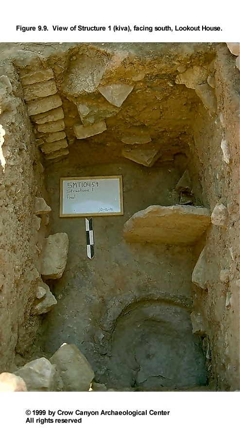
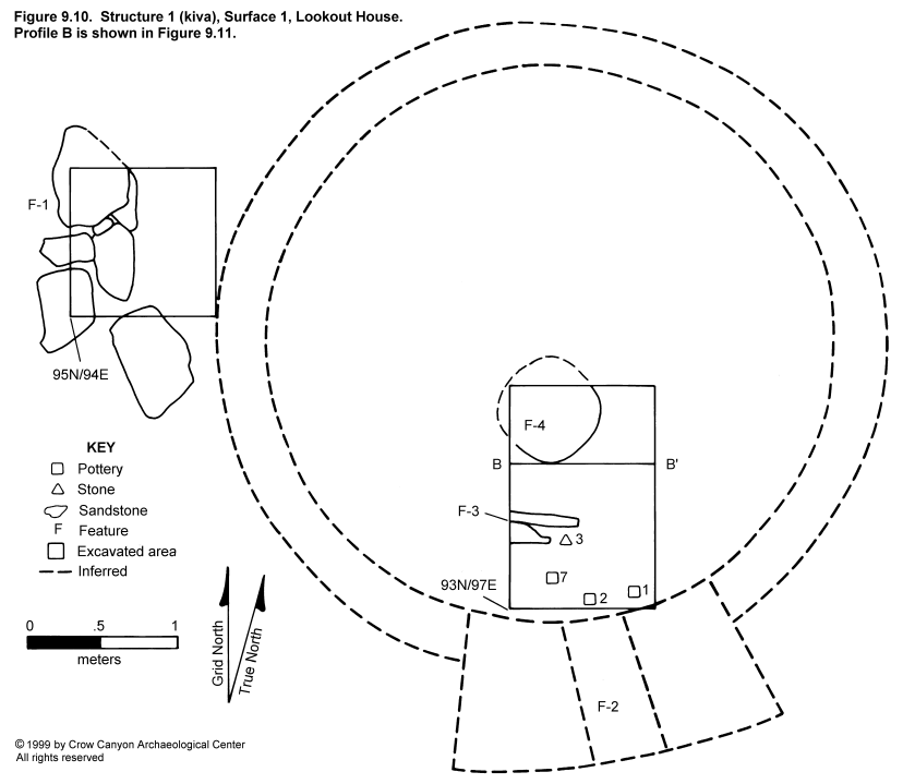
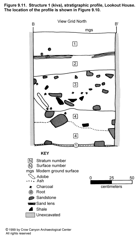
Structure 1 is a unburned, masonry-lined kiva (Figure 9.9 and Figure 9.10) The structure was tested by the excavation of random units 93N/97E and 95N/94E and judgmental unit (0.5 × 1 m) 94N/97E. The random units exposed a section of retaining wall associated with kiva construction, a portion of the deflector slab, and a short section of bench face at the east edge of the ventilator tunnel opening. The judgment unit exposed most of the hearth. The extrapolated diameter of the kiva is 3.85 m, bench face to bench face.
Construction
The architectural construction observed in the excavated portion of Structure 1 is described in this section, including the walls, roof, and floor (Figure 9.10 and Figure 9.11).
Walls. Excavation in Structure 1 exposed a section of bench face. This bench was exposed in the southeast corner of the test pit and includes the east edge of the ventilator tunnel opening. The only evidence of the upper lining wall in this structure was observed in unit 95N/94E. Along the east edge of that unit, what is probably the outside face of the upper lining wall was exposed (see Feature 1 description below).
The exposed section of the bench measures 19 cm long and 95 cm high; eight vertical courses of stone were visible. All of the stones observed were shaped by pecking. Most of this shaping was done to form one end of each rock into a right-angle corner to finish the edge of the ventilator tunnel opening. All observed rocks were of block shape. The wall rests on a foundation of undisturbed calcium carbonate. The chinking is 90 percent chunk and 10 percent spall.
The mortar is light brown with calcium carbonate inclusions. The beds are flush with the rock faces, and they measure 2 cm wide and 1 to 2 cm thick. No plaster was observed on the face of the wall.
Roof. Testing revealed no direct evidence of roofing construction in Structure 1. No pilasters were exposed in the test pits. The stratigraphy in the small area excavated did include a thick stratum of what was interpreted as roof fall resting on the floor (Figure 9.11). This stratum consists of the sediment portion of the roof; no vegetal material is included. The location of roof fall directly on the floor indicates that the roof collapsed when the structure was abandoned, before wind- and water-deposited sediments could accumulate. The absence of vegetal material in the roof fall suggests that the timbers were salvaged. The absence of trash in the fill of the kiva indicates that Structure 1 was abandoned at the same time that the site was abandoned. These three pieces of evidence may indicate that the roof was intentionally collapsed for the salvage of roofing materials when the site was abandoned.
Surface 1. Surface 1 is the floor of Structure 1. It is formed of undisturbed sterile deposits of shale containing calcium carbonate and fragments of decomposing sandstone. Adobe coats the floor around the hearth, concealing the original hearth rim. Yellowish mortar anchors the vertical deflector slab to the floor.
Surface 1
Surface 1 is the floor of Structure 1 (Figure 9.10). Testing exposed a 1.5-m² area in the south-central portion of the structure. Three features and four point-located artifacts are associated with this floor.
Features. Portions of the ventilator system, the deflector, the hearth, and a section of associated retaining wall were documented.
Feature 1 (Retaining Wall): A short section of what appears to be a massive retaining wall was exposed in the west half of random unit 95N/94E. The proximity of this wall to Structure 1 (Figure 9.10) led to the interpretation that this construction is associated with Structure 1.
The exposed portion of Feature 1 is oriented north-south, and it measures 1 m long, 60 cm high, and 68 cm wide. It consists of approximately two vertical courses of large, unshaped sandstone blocks. No mortar was observed. The original height of the wall is unknown, as is its relationship to prehistoric ground surface.
The construction technique of this wall was difficult to discern. The wall rests on 35 vertical centimeters of yellowish brown fine sandy silt containing charcoal and calcium carbonate flecks, numerous sandstone bits and rocks up to fist-size, small pockets of decomposing shale, and nodules of redder, redeposited sterile sediment. This material appears to be construction fill, and it rests on undisturbed gray clay. The fill continues east of the wall and slopes down 10 cm to abut stacked sandstone rocks at the east edge of the test pit. These sandstone rocks are probably the outside face of the upper lining wall of Structure 1.
Feature 2 (Ventilator System): Only a very small portion of the ventilator system was exposed during testing. The east edge of the tunnel opening was observable in the bench face just inside the south face of the test pit. See the description of the Structure 1 wall for a description of the masonry that formed this tunnel opening. The fill of the ventilator tunnel visible at this opening was the same as the fill described for the structure main chamber (see Figure 9.11 and stratigraphic descriptions).
Feature 3 (Deflector): The deflector is a large, vertical sandstone slab set into the floor. The exposed portion of the slab measures 48 cm long by 6.5 cm thick, and it rises 59 cm above the floor. The edges of the slab have been shaped by flaking. An additional large slab leans against the south face of the deflector and appears to be supporting it.
Yellowish mortar was observed around the base of the deflector slab. It is assumed from the size of the slab that it must be set into a groove in the floor for stability, although because the mortar was not removed, no groove was observed. But otherwise, not even the mortar and the support slab would be enough to keep the deflector vertical. There is no evidence of remodeling of the deflector system, although the location and orientation of the deflector does not appear to be optimal for redirecting air flow from the ventilator tunnel opening.
Feature 4 (Hearth): The majority of the hearth was exposed in judgment unit 94N/97E; only the north and west edges of the feature remain unexcavated. The exposed portion of the hearth measures 62 × 60 cm, and it is 20 cm deep. The feature was constructed by excavating a nearly circular, basined pit into undisturbed sterile material (a mixture of calcium carbonate, gray shale, and decomposing sandstone). Gray shale bedrock is exposed at the base of the pit, but this may have been coated with adobe originally. The north and northwest areas of the feature have been damaged by animal activity.
The original east and south walls and rim of this hearth are thermally altered shale. At some time, the feature was remodeled by adding 4 to 6 cm of adobe to the east and south upper walls and the rim of the pit. This adobe is charred and is dark gray or very dark reddish brown.
The hearth was filled with use-associated light gray to white ash with inclusions of charcoal and burned adobe nodules. A metate fragment was recovered from the fill. A few pieces of sandstone were also within the fill. Only one of these stones showed evidence of heat exposure and thus was probably associated with hearth use. The remainder are believed to have been deposited in the hearth after the structure was abandoned.
Five 1-liter flotation samples were collected from the ash in this hearth; two of these samples were analyzed, and the results are reported in Chapter 16. The remaining ash was dry-screened through one-sixteenth-inch mesh, and the residue was collected but not analyzed. Archaeomagnetic dating samples were collected--see the Dating section below.
Artifacts. Several artifacts were recovered from Surface 1 of Structure 1: six sherds from a Pueblo III White Painted ladle handle (PLs 1 and 2); one Pueblo III White Painted jar body sherd (PL 7); and six pieces of chipped-stone debris (PL 3).
Stratigraphy
Structure 1 is filled with roof fall and natural postoccupational deposits (Figure 9.11). This stratigraphy is described from the modern ground surface down to the floor.
Stratum 1 is a yellowish brown to dark yellowish brown sandy loam containing small charcoal fragments and sandstone bits. The boundary with Stratum 2 is abrupt and smooth. This stratum was naturally deposited, long after the structure was abandoned.
Stratum 2 is a light brown to dark brown sandy loam containing calcium carbonate flecks, small sandstone bits, a few fist-size stones, and small bits of charcoal and shale. The boundary with Stratum 3 is abrupt and smooth. This stratum contains a series of natural (alluvial, colluvial, and aeolian) deposits that accumulated after the roof collapsed. The sand lenses at the top of the stratum are alluvial.
Stratum 3 is a sandy loam that ranges from light brown to dark brown. The following inclusions were noted: numerous pieces of shale ranging from small bits to chunks measuring 6 × 17 cm; pieces of sandstone ranging from small bits up to fist size; sparse but sizable chunks of unburned adobe; and small pieces of charcoal and calcium carbonate. The boundary with Stratum 4 is abrupt and irregular.
Strata 3 and 4 are similar in texture, color, and inclusions, although Stratum 3 contains more inclusions. Both strata are thought to have resulted from structural collapse. The variation in the number of inclusions may be a result of "cleaner" sediment having been used immediately on top of the vegetal component of the roof, with less-suitable material having been used for the uppermost deposits.
Stratum 4 contacts the floor and consists of a light brown to strong brown sandy loam containing small sandstone pieces and shale bits and nodules. Larger rocks and shaped building stones were also noted. A thin layer of ash coats the floor surface. The boundary between Stratum 4 and Surface 1 is very abrupt and smooth.
Stratum 4 is massive, and contains redeposited sterile material assumed to have been mined from subsurface deposits as a result of the excavation of this kiva. Mined material thus acquired was commonly reused during the construction of the structure roof. Thus, Stratum 4 is believed to be the remains of the collapsed roof. The absence of any evidence of roofing timbers suggests that they were salvaged when the structure was abandoned.
The fill of Structure 1 contained few artifacts: one Mesa Verde Corrugated Gray sherd, Indeterminate Local Corrugated Gray sherds (N = 38), Mesa Verde Black-on-white sherds (N = 2), Pueblo III White Painted sherds (N = 5), Late White Unpainted sherds (N = 38), a nodule of gypsum/calcite/barite, chipped-stone debris (N = 25), and a number of nonhuman bones.
Dating
No tree-ring dates are available for Structure 1. Archaeomagnetic samples yielded date ranges of A.D. 930-1020, 1300-1500, and 1600-1675. The time of abandonment of the structure and the site is believed to be nearest to the A.D. 1300-1500 range; the few tree-ring dates from the site date construction to sometime after A.D. 1257. Stratigraphically, this kiva is contemporaneous with Structure 2 (kiva) and with other naturally filled structures at this site. Only Structure 7 (see Sampling Stratum 1), which is filled with refuse, appears to predate some of the other structures at Lookout House.
Interpretations
Structure 1 is an unburned, masonry-lined kiva. It is interpreted as a kiva because of its depth, stratigraphy, and floor construction, as well as the presence of a masonry bench, formal hearth, deflector, and ventilator tunnel opening. Although evidence of a typical, coursed masonry upper lining wall was observed in test pit 95N/94E, the method of upper wall construction along the southern edge of the structure was not observed and is unknown. The bench surface exposed in test pit 93N/97E is only 8 cm below modern ground surface, so the upper lining wall may have extended well above prehistoric ground surface originally.
If proximity reflects association, then Structure 1 may be associated with Structures 3 and 4 (surface rooms), which are less than 2 m west of Structure 1. The functions of these rooms are unknown; however, a metate and several manos were recovered from the northeast corner of Structure 4. These artifacts could indicate that food processing occurred in this structure or that the structure was used for the storage of these tools.
Structure 1 appears to have been abandoned when the entire site was abandoned. If the structure had been abandoned prior to site abandonment, one would expect to see trash fill in the kiva depression (as with Structure 7). The absence of organic material in the fill suggests that the roof was dismantled for the salvage of timbers. The absence of wind- and water-deposited sediments between the floor and roof fall indicates that the roof was dismantled when the structure was abandoned.
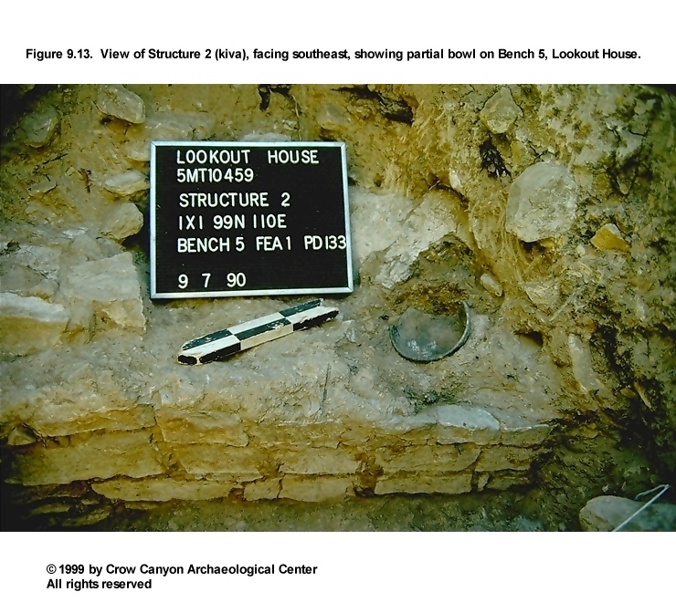
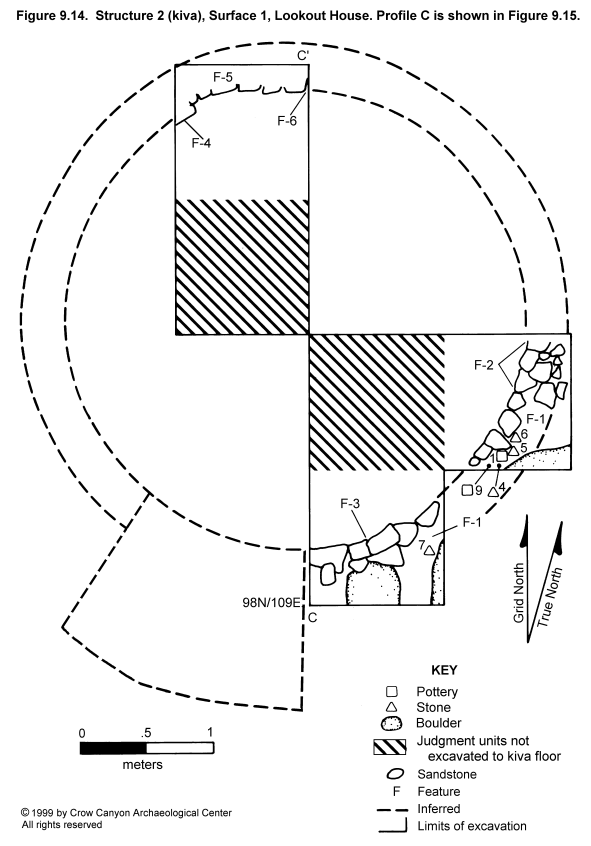
Structure 2 (Kiva)
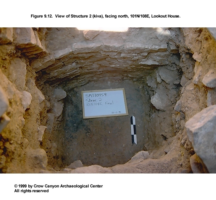
Structure 2 is an unburned, masonry-lined kiva (Figure 9.12, Figure 9.13, and Figure 9.14). Three random test pits (98N/109E, 99N/110E, and 101N/108E) were excavated to the floor; two judgmental pits were excavated approximately to the level of the bench surface (1.0-1.2 m below the modern ground surface). Excavation of the random units exposed 1.6 m² of floor, three sections of bench, three pilasters, and one niche. A human burial was found above the bench surface in unit 101N/108E; another was encountered at the level of the bench surface during excavation of one of the judgment squares. Neither burial was completely exposed. The extrapolated diameter of the kiva is 3.4 m, bench face to bench face.
Construction
The architecture observed during testing of Structure 2 is described in this section.
Walls. Three sections of bench face were exposed during testing (Figure 9.14); no upper lining wall was observed. The exposed portion of the bench is of semicoursed sandstone masonry and is a single stone wide. The bench faces bell outward at the bottom 8 to 20 cm. The mortar is a strong brown, fine-textured sediment that contains flecks of calcium carbonate and charcoal, as well as small pieces of sandstone and shale. The bench segments rest on a foundation of undisturbed gray clay.
The portion of the north bench face documented in 101N/108E is 1 m long and 83 cm high (11 courses). The width of this section of bench could not be documented, because the bench surface was not exposed. A human burial was encountered 41 to 48 cm above the bench surface, and so a balk was left unexcavated to permit the body to remain in situ (see Feature 7, below).
Approximately 15 percent of the north bench face was obscured by plaster. The following description applies to the observable bench-face stones only. Seventy-five percent of the stones are unshaped, 15 percent are pecked, and 10 percent are flaked. Fifty percent are blocky, 5 percent are tabular, and 45 percent are irregularly shaped. Mortar beds measure 1 to 4 cm wide and are up to 2 cm thick. Chinking stones are chunky.
The east bench face (in 99N/110E) measures 1.10 m long and 84 cm high (six or more courses); the masonry itself is 18 cm wide. Plaster obscures 35 percent of this face. Sixty percent of the stones are unshaped, 10 percent are pecked, 10 percent are flaked, and 20 percent of the wall is formed by a boulder face. Sixty percent of the rocks are block-shaped, 20 percent are tabular, and 20 percent is formed by the boulder face. Mortar beds are 2 cm wide and 2 cm thick. Chinking is tabular.
The south bench face (in 98N/109E) measured 1.04 m long and 88 cm high (six to eight courses estimated), and the masonry is 20 cm wide. Plaster obscured 50 percent of this face. Sixty percent of the rocks are unshaped, 20 percent are pecked, and 20 percent are flaked. The rocks are 60 percent block-shaped, 20 percent tabular, and 20 percent irregular. The mortar beds are 2 cm wide and 4 cm thick; no chinking stones were present.
As many as three coats of plaster were observed on these bench faces. The plaster coats total 1 cm in thickness and are better preserved on the lower half of the bench face than on the upper half. No paint or other decoration was noted on the surface of the plaster, nor could any finger impressions be detected. The color of the plaster is yellowish brown in cross section; the surface of the plaster is sooted a grayish brown. The outermost coat was slightly darker than the inner coats. The texture is silt loam, with inclusions of calcium carbonate flecks, tiny sandstone and shale bits, and sparse charcoal flecks. The plaster did not adhere well to the bench face at the time of excavation.
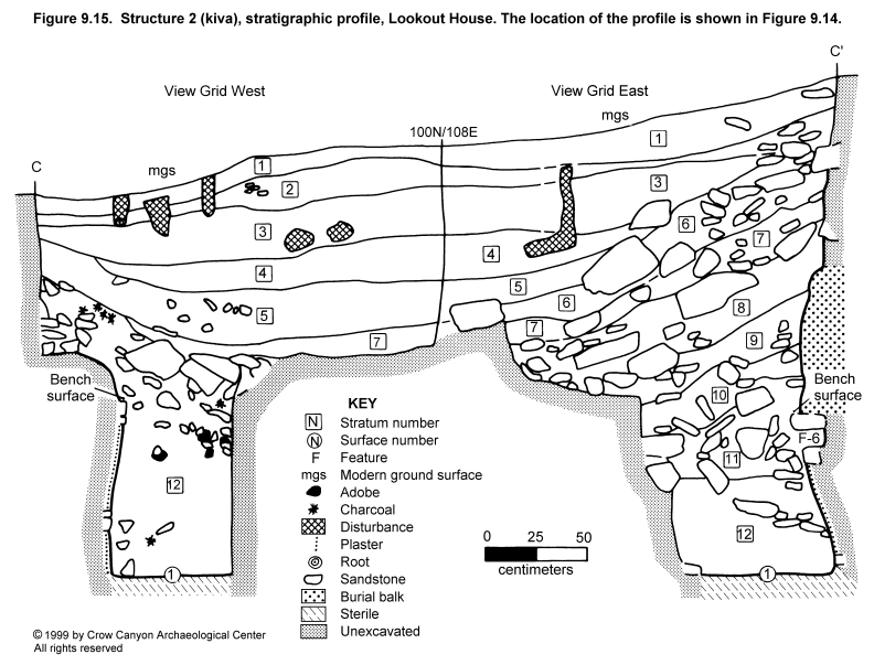
Roof. No direct evidence of roof construction was noted. However, portions of Pilasters 3, 5, and 6 were exposed and indicate that the roof was a typical, pilaster-supported, cribbed kiva roof (see Features 2, 3, and 4 below). A stratum of roof fall devoid of vegetal material was observed resting on the floor (Figure 9.15).
Surface 1. One use surface, the floor, was documented in Structure 2 (Figure 9.14). Although the entire floor was probably coated with adobe originally, preservation varied between test pits. In 99N/110E, the floor was predominantly undisturbed gray clay, but a few small patches of adobe survived. In 98N/109E, a larger area of adobe was preserved on top of the gray clay. In 101N/108E, the floor was a continuous layer of blackened adobe atop undisturbed gray clay. The blackening is a very thin residue that appears to be soot but may be a film of unburned, decomposed organic material.
Surface 1
Surface 1 is the floor used during the occupation of Structure 2. It is undisturbed gray clay coated with adobe. Several features and artifacts were documented as being associated with the occupation of the structure.
Features. Eight features were recorded in this structure. They are described below in numerical order. Bench segments and pilasters are numbered clockwise beginning west of the southern recess. For a description of the bench faces, see Walls above.
Feature 1 (Bench 5): This bench segment was exposed in units 98N/109E and 99N/110E. A 40-cm-long section of Bench 5 was exposed in one unit, and a 62-cm-long section was exposed in the other. The inside edge of the bench surface is formed of the top course of the bench-face masonry; the remainder of the surface consists of redeposited sterile sediment. A thin lens of ash of unknown origin rested on the bench surface.
The width of the bench is unknown because the outside edge is usually determined by the location of the upper lining wall, and no upper lining wall was preserved. A large boulder that was exposed in both of these test pits may have formed part of the upper lining wall (Figure 9.14). Artifacts associated with the bench surface are discussed under the Artifacts heading below.
Feature 2 (Pilaster 5): This pilaster is very poorly preserved. The portion that is within 99N/110E measures 48 cm wide, 42 cm front-to-back, and 20 cm high. Only one course of masonry survives, but the pilaster is assumed to have been the typical column originally. The stones observed had been shaped by flaking. The pilaster rests on the bench surface, which consists of the top of bench-face masonry at the front edge and redeposited sterile sediment behind that.
Feature 3 (Pilaster 6): This pilaster is not intact, but it is better preserved than Pilaster 5. It is composed of shaped, tabular sandstone and measures 62 cm wide, 31 cm front-to-back, and 28 cm high. As many as three vertical courses survive. The only intact horizontal course is the one that forms the front edge of the pilaster. The fate of the back portion of this pilaster is a mystery; it is difficult to envision a scenario in which the back of a pilaster is destroyed while the front remains intact. The pilaster rests partly on the top of the bench-face masonry, partly on redeposited sterile behind the bench face, and partly on a boulder top that slopes down toward the bench face.
Feature 4 (Pilaster 3): The east edge of this pilaster protrudes from the west face of the test pit (101N/108E). Six vertical courses are more or less intact. The bottom of the pilaster is in the original position, but the rest of the column leans 15 cm toward the interior of the kiva. This was probably caused by massive amounts of postabandonment fill entering the structure from uphill (north), or behind the pilaster.
The feature is 47 cm high; 12 cm of width is exposed, and 15 cm of depth is observable, front-to-back. The front faces of these rocks have been shaped, but the sides of the rocks that are visible have not been pecked to form a 90 degree angle as is typical for a pilaster corner. Thus, perhaps the rocks observed did not form the east corner of this feature. A very small patch of soot-darkened plaster was noted on the lowermost rock of the pilaster.
Feature 5 (Bench 3): A portion of this bench segment was observed in 101N/108E. Only a 5 cm deep strip of bench surface was exposed. This is because a balk was left in order to preserve a human burial (Feature 7) encountered approximately 40 cm above the bench. Bench 3 measures 102 cm long, and it is 79 to 84 cm above the kiva floor. The bench face has been described above, under Walls.
Feature 6 (Niche): This feature was uncovered at the east end of the exposed face of Bench 3. The opening is roughly square, and it is one horizontal masonry course (7 cm) below the bench surface. The floor of the niche is 65 cm above the kiva floor.
The opening measures 13 cm high and 13 cm wide, and it extends 14 cm into the bench face. The niche was formed by leaving a horizontal gap between two stones in the second course of the bench face. The fill inside the niche was the same as the fill in the main chamber of the kiva at that level (Figure 9.15). No artifacts were associated with the feature, and no plaster or coping was noted inside. The niche is assumed to have been used for storage.
Feature 7 (Burial): This human burial was encountered along the north wall of unit 101N/108E. The skeleton was exposed only enough to determine that it was articulated; a balk preserving the remains and their context was then maintained. The bones were not exposed or removed due to time constraints and to the current sensitive political climate regarding human burials.
The skeleton is that of a child. The total body length is estimated to be 70 to 78 cm. The body is extended, and it is oriented grid east-west, with the cranium to the west. Small portions of the following elements were observed: cranium, probable right humerus, possible right radius, innominate, and possible right femur. The exposed bone appears very delicate and friable, possibly due to the young age of the individual at the time of death. The cranium was protected by large rocks that had been placed around it. No grave-associated goods were observed.
The body was interred in the fill of Structure 2, inside the north upper lining wall. It rests 1.0 m below the modern ground surface, 41 to 48 cm above the bench surface, and 1.5 m above the kiva floor. On the basis of the limited exposure, it appears that a pit was excavated into the top of the naturally deposited Stratum 8 structural collapse (see Figure 9.15).
Feature 8 (Burial): This burial was encountered in judgment unit 99N/109E. Excavation ended when the cranium was exposed. As with Feature 7, this burial was left in situ due to time constraints and to the current sensitive political climate regarding human burials.
The cranium is 1 m north of the south bench face and 1 m west of the east bench face. The body is probably oriented grid southeast-northwest, with the cranium to the southeast. The body appears to have been interred into the top of roof fall (Stratum 12).
Artifacts. No artifacts were interpreted as being associated with the kiva floor, but the following artifacts were point-located on the surface of Bench 5: four sherds from a small, Pueblo III White Painted bowl (PL 1); chipped-stone debris (PLs 4, 5, 6, and 7); and an Indeterminate Local Corrugated Gray jar body sherd (PL 9).
Stratigraphy
The fill of Structure 2 consists of roof fall and other structural collapse and of colluvial, alluvial, and aeolian postabandonment deposits (Figure 9.15). The stratigraphy is described from the modern ground surface down to the structure floor.
Stratum 1 is a yellowish brown to strong brown fine silty sand, containing small sandstone bits and larger rocks (as mapped) and a moderate number of calcium carbonate flecks. This is the recently deposited duff layer.
Stratum 2 is a yellowish brown to strong brown fine sandy silt to sandy loam, containing a moderate number of calcium carbonate flecks, sandstone (as mapped), tiny and sparse bits of shale, and fine sand and gravel lenses. This stratum is recent alluvial, colluvial, and aeolian material deposited on top of the kiva fill.
Stratum 3 is a brown loam to silty clay loam containing sand lenses, some calcium carbonate flecks, small sandstone bits, and shale flecks. The boundary with Stratum 4 is very abrupt and smooth. This stratum contains at least two alluvial depositional events, represented by a gradation of coarse sand through silty clay loam. This stratum was probably the final material to be deposited into the kiva depression.
Stratum 4 is a brown loam to silty clay loam containing sand lenses, a moderate number of calcium carbonate flecks, small sandstone pieces, and a few larger sandstone pieces. The boundary with Stratum 5 is smooth and clear to abrupt. This stratum is mostly alluvial and aeolian, but the larger pieces of sandstone must have been moved colluvially.
Stratum 5 is a grayish brown silt loam to silty clay loam containing a few larger sandstone blocks, more numerous fist-size stones, abundant calcium carbonate flecks, some charcoal pieces, and some sand lenses. The boundaries with Strata 6 and 7 are very abrupt and smooth. This stratum appears to be predominantly alluvial sediment from the south edge of the kiva depression.
Stratum 6 is a brown to dark brown sandy loam containing abundant sandstone rocks as large as boulder size (no shaping observed), a few calcium carbonate flecks, and tiny, sparse, charcoal flecks. The boundary with Stratum 7 is very abrupt and smooth. Some of the sandstone is probably building rubble from outside the structure (from surface rooms and Structure 8), but some is probably talus.
Stratum 7 grades in color from the north end of the structure (between pinkish gray and light brown) to the south end of the structure (reddish yellow). The texture grades from silt loam to sandy clay loam. This sediment contains large, sparse charcoal pieces, calcium carbonate nodules, and sandstone (most is toward the north end of the profile). The boundary with Stratum 8 is abrupt and smooth. The north part of the stratum contains shaped sandstone that may be from the north upper lining wall of this kiva, but it was deposited so long after abandonment and is so high in the structure fill that it is more likely that the stones are either from a nearby surface structure (to the northwest) or are rubble that came down the natural chimney from Structure 8.
Stratum 8 is also a brown clay loam, and it is very similar to Stratum 9. Stratum 8 contains a smaller amount of coarse sand, is slightly lighter in color, and contains fewer inclusions. This stratum also contains abundant postabandonment structural collapse.
Stratum 9 is a brown clay loam containing numerous large sandstone rocks (many are shaped), charcoal pieces, very coarse sand, pockets of gray shale and clay, unburned adobe melt and pockets of adobe, and sparse calcium carbonate nodules. The boundary with Stratum 10 is very abrupt and smooth. The inclusions in Stratum 9 indicate that it consists of postabandonment structural collapse from the north wall of the kiva. It is possible that some of the materials in this stratum are also derived from surface rooms northwest of the kiva or from Structure 8 on top of the cliff.
Stratum 10 is a very pale brown silt loam containing abundant calcium carbonate flecks and sandstone rocks as large as fist size. The boundary with Stratum 11 is very abrupt and smooth. The origin of this deposit is unclear. It is sandwiched between roof fall and wall collapse but contains no charcoal, shale, or clay. Except for the calcium carbonate and the sandstone, it is "clean" and homogeneous, and it is not mixed with the stratum above or below. The calcium carbonate inclusions indicate that the material originated from below prehistoric ground surface, and so it is probably constructional collapse.
Stratum 11 is a dark gray redeposited shale, with a minor amount of silt mixed in. This unconsolidated deposit contains abundant sandstone (some shaped), ranging from small bits to building-stone size. Also observed were calcium carbonate flecks and small, sparse nodules of unburned adobe. The boundary with Stratum 12 is clear and wavy.
The main component of this stratum is redeposited shale, and it appears to be constructional collapse. This material is the upper limit of roof fall, so it probably was used in some capacity around the periphery of the roof. The large number of rocks, mostly unshaped and of various sizes, leads to the interpretation that the shale was around the periphery of the structure and that it mixed with talus when it entered the structure depression.
Stratum 12 is a very mottled, brown to yellowish brown loam to silt loam. Inclusions are abundant in this massive deposit, composing nearly 50 percent of the volume. Numerous pieces of sandstone are present, ranging from small bits to rocks the size of building stones; some are shaped. In addition, there are numerous bits of shale, small pockets of gray clay, very sparse unburned adobe nodules and calcium carbonate flecks, and some pieces of charcoal. The boundary with Surface 1 is very abrupt and smooth.
This stratum is a deposit of structural collapse. The remains of the fallen roof (minus the vegetal component) are in direct contact with the floor; wall collapse is mixed in with the roof fall and is more plentiful higher in the stratum. The position of this deposit on the floor of the structure indicates that the roof collapsed when the structure was abandoned. The absence of vegetal material suggests that the timbers were salvaged at that time for reuse elsewhere.
Artifacts recovered from the fill of Structure 2 appear to have been naturally deposited after the site was abandoned and consist of the following:
- Indeterminate Local Corrugated Gray sherds (84)
Mesa Verde Corrugated Gray sherd (1)
McElmo Black-on-white sherds (2)
Mesa Verde Black-on-white sherds (4)
Pueblo III White Painted sherds (17)
Late White Unpainted sherds (74)
modified sherd (1)
unfired sherd (1)
mano fragment (1)
two-hand mano fragment (1)
bone awl fragments (2)
complete single-bitted axe (1)
modified flakes (2)
nodules of unfired clay (2)
sample of reddish brown pigment (1)
pieces of chipped-stone debris (43)
gizzard stone (1)
nonhuman bones
Dating
No absolute dates are available for Structure 2. The pottery recovered from the lower fill and bench surface indicate that the structure is contemporaneous with the other architecture and with the midden deposits at this site. The absence of secondary refuse in the structure fill suggests that the structure was abandoned at the same time that the site was abandoned.
Interpretations
Structure 2 is an unburned, masonry-lined kiva. The structure is interpreted as a kiva because of its substantial depth, the presence of a bench, the curvature of the bench face, and its masonry lining, pilasters, and prepared floor. The structure appears to be contemporaneous with the other architecture and the refuse at Lookout House.
The kiva appears to have been constructed in the following way: a pit was excavated from prehistoric ground surface down into undisturbed gray clay (the boundaries of this pit were not observable in the test units excavated, so the diameter of the pit is not known). Within this pit, the bench face masonry was constructed, and the gap between this masonry and the undisturbed sterile pit edge was filled with redeposited sterile sediment up to the bench surface. Pilasters were then constructed on the bench surface. No upper lining wall construction was observed in Structure 2. The floor was coated with adobe.
It is not known which structures are associated with this kiva. There is evidence that masonry surface structures are present to the northwest (Figure 9.4); some or all of these may be associated with the use of this kiva. There is also a subterranean, masonry-lined structure (Structure 6) 1 to 2 m to the east, and this may be associated with, and could even be connected by a tunnel to, Structure 2. The function of Structure 6 is unknown (see Structure 6, Interpretations).
The absence of intentionally deposited refuse in the fill of Structure 2 indicates that the structure was abandoned at the same time as the site as a whole. Roof fall is in direct contact with the floor, which suggests that the roof collapsed or was intentionally collapsed at the time of abandonment. The absence of any evidence of roofing timbers indicates that they were removed at abandonment.
Pit Structures (Sampling Stratum 2) Summary
Testing in the pit structure sampling stratum resulted in the definition of two kivas (Structures 1 and 2) and a section of retaining wall associated with Structure 1. Five random 1-×-1-m units and three judgmental units were excavated in this stratum. Random units 93N/97E and 95N/94E and judgment unit 94N/97E (.5-×-1-m) were excavated in Structure 1. These test pits exposed portions of the floor, hearth, deflector, bench face, ventilator tunnel opening, back side of the upper lining wall, and a section of associated retaining wall. The structure filled naturally after the roof was dismantled for the salvaging of roof timbers. Structure 1 may be associated with masonry Structures 3 and 4, which are a few meters to the west.
The hearth of Structure 1 was dated by archaeomagnetism. One of the resulting date ranges (A.D. 1300-1500) is slightly later than the few tree-ring dates from the site.
The three random and two judgment units in Structure 2 exposed portions of the floor, bench faces, bench surfaces, three pilasters, a niche, and two human burials. Structure 2 may be associated with untested surface structures to the northwest or with the subterranean structure to the east (Structure 6). No absolute dates are available for Structure 2, but the pottery and naturally deposited fill indicate that the structure is contemporaneous with Structure 1.
Courtyard (Sampling Stratum 3)
The courtyard sampling stratum surrounds the pit structures and surface structures at Lookout House, and it was probably used regularly by the site inhabitants for outdoor activities. The outer limit of this stratum was generally defined by the main site retaining wall. The courtyard as defined is 97 m² in area. Four randomly selected 1-×-1-m units were excavated to sample this stratum (93N/101E, 97N/100E, 101N/112E and 102N/117E). A diagonal judgment trench northeast of random unit 93N/101E was excavated to help us better define a wall exposed in that random unit.
Eight features--four sections of walls, three burned areas, and a possible doorway--were recorded during testing of the courtyard. These features are described below under the appropriate unit headings.
Sampling Unit 97N/100E
Random unit 97N/100E is located between the kivas. Three features were documented in this unit--two burned spots and a segment of wall. The stratigraphy observed in this unit is described first; feature discussions follow in numerical order.
Stratigraphy
The stratigraphy in 97N/100E is associated with the construction of Feature 5 (wall) (Figure 9.16). These deposits are described from the modern ground surface down to undisturbed sterile sediments. Stratum 1 is a dark yellowish brown sandy silt containing sparse sandstone rocks and very sparse charcoal and calcium carbonate flecks. This material was naturally deposited after the site was abandoned.
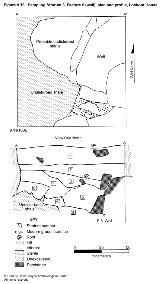
Stratum 2 is a brown sandy silt containing numerous small pieces of sandstone, gravel, and charcoal. The base of this deposit slopes down to the east. The charcoal flecks and the presence of Features 1 and 2 (see below) near the bottom of the stratum seem to indicate that this material accumulated naturally during the occupation of the site.
Stratum 3 is a strong brown silt loam containing small sandstone bits and small and sparse charcoal and calcium carbonate flecks. This material is the same color as Stratum 6 (sterile) and may be redeposited sterile sediment resulting from the excavation of a pit for the bottom courses of Feature 5 (wall) or for whatever construction is east of this wall.
Stratum 4 is a light brown silt loam containing charcoal and calcium carbonate flecks and small sandstone bits. The western portion of this stratum appears to rest on undisturbed sterile sediment (Stratum 6). Both Strata 4 and 6 may have been truncated during excavation for the base of the Feature 5 wall. There is no clear truncation line in Stratum 4; however, this may be due to natural slumping of the upper edge of the excavation or to intentional slumping during backfilling after construction of the wall was completed. In any case, Stratum 4 was the first cultural material to be deposited during the occupation of the site, as it rests on undisturbed sterile sediment at the west end of the profile face.
Stratum 5 is a reddish yellow silt loam containing numerous white and yellow sandstone bits and some calcium carbonate flecks. This stratum appears to be Stratum 6 (sterile) sediment that was redeposited after the construction of the wall, although it is slightly less orange and slightly less sandy than Stratum 6.
Stratum 6 is a strong brown silt loam with calcium carbonate flecks and sandstone pebble inclusions. This material appears to be undisturbed sterile sediment that was truncated by the excavation of a pit that extends outside this test pit to the east. The undisturbed, decomposing shale below it has been truncated too, but there is no evidence of redeposited shale in this test unit. The top of Stratum 6 was apparently prehistoric ground surface at the beginning of site occupation.
In summary, Stratum 1 is a postabandonment deposit; Stratum 2 accumulated during the site occupation, after the wall was constructed (contains two cultural features); Strata 3 and 5 are probably redeposited sterile sediments used as backfill after the construction of the wall; Stratum 4 accumulated during the site occupation, but before wall construction; and Stratum 6 is undisturbed sterile sediment. For additional discussion, refer to the Feature 5 (wall) description.
Feature 1 (Burned Spot)
This feature consists of a small burned area with a fire-reddened perimeter and associated small, burned, sandstone rocks. The feature measures 20 × 18 cm in plan; it is 4 cm deep and is located 23 cm below the modern ground surface. The fill is burned sediment containing no artifacts. The function of this feature is unknown; it appears to be too shallow for a post hole, and it is too small and lightly burned to have been an intensively used hearth. The most likely interpretation is that the feature is the result of a single fire having been built on the prehistoric ground surface for some unknown purpose. It is not unlikely that this feature is associated with Feature 2, which is another burned spot, located 5 cm west of Feature 1.
Feature 2 (Burned Spot)
This burned spot is similar to Feature 1. It measures 15 × 14 cm; it is 3 cm deep and is located 23 cm below the modern ground surface. The fill consists of burned sediment containing charcoal flecks and small, burned, sandstone rocks. No artifacts were associated with the feature. This burned spot is probably the result of a brief, small fire having been built on the prehistoric ground surface.
Feature 5 (Wall)
Feature 5 is a 1.05-m-long segment of wall exposed along the east edge of this random unit (Figure 9.16). The top of this wall was uncovered 30 cm below the modern ground surface. The construction appears to extend below the level of undisturbed sterile in the western half of the test pit. Exposed is 38 cm of height and 50 cm of width. Two courses of large, blocky sandstone and smaller, more tabular rocks are observable; none of the sandstone is shaped. For additional information on construction, see the Stratigraphy section above.
This wall is difficult to interpret on the basis of the small portion exposed. The exposed face appears to be convex and thus may be a segment of a curved retaining wall. The fact that the wall (in the eastern portion of the unit) continues downward below the level of undisturbed sterile sediment (in the western portion of the unit) may indicate that this wall lines the west edge of a subterranean or semisubterranean structure east of this test pit. It is also possible, however, that a trench was excavated into sterile sediments to provide a more stable foundation for what was basically an above-ground structure wall or retaining wall. A more conclusive interpretation cannot be reached without additional excavation.
Sampling Unit 93N/101E
Random test pit 93N/101E is located a few meters east of Structure 1. Segments of two walls (Features 3 and 4) converge in this unit (Figure 9.4). A possible doorway (Feature 8) was documented in the westernmost wall. The stratigraphy is discussed first, and feature descriptions follow.
Stratigraphy
Stratum 1 is the uppermost 90 cm of fill in this unit; it consists of a brown fine sandy loam containing sandstone rubble, small sandstone bits, charcoal and calcium carbonate flecks, numerous artifacts, and one small pocket of ash. This material accumulated after the site was abandoned, and it contains wall collapse from Features 3 and 4 (walls). The bottom of this stratum coincides with the bases of these walls. A shaped door slab measuring 38 cm long and 24 cm wide was noted in fill near the bottom of Stratum 1.
Stratum 2 is a reddish brown, sandy clay loam containing sandstone inclusions. This material is present only in the southeast corner of the unit, and it may be construction fill that was designed to form a level foundation for the base of Feature 3.
Stratum 3 is undisturbed, sterile gray shale. Feature 4 (wall) was built on this deposit; Feature 3 rests a few centimeters above the shale, on Stratum 2.
Feature 3 (Retaining Wall)
The top of Feature 3 (retaining wall) was barely discernible on the modern ground surface. The segment of wall exposed in unit 93N/101E is 107 cm long and 37 cm wide, and it extends 93 cm below modern ground surface (Figure 9.4). The exposed face is convex, curving from northwest to southeast. The wall is semicoursed, and it contains approximately four courses of sandstone boulders, blocks, and chinking stones. Some of the blocks have been shaped. No mortar is observable, but mortar was probably present originally.
Feature 3 is inferred to be a retaining wall. This inference is based on its massive construction and on the imprecise placement of rocks that vary widely in size and shape. This wall is tied to Feature 4 (wall) near the northwest corner of the excavation unit; thus, these two features were constructed at the same time.
Feature 4 (Wall)
Feature 4 is a 60-cm-long segment of wall exposed in the west face of random unit 93N/101E (Figure 9.4). The exposed face is convex, curving from northeast to southwest. The construction extends 82 cm below the modern ground surface and rests on undisturbed sterile gray shale. The wall is semicoursed, and approximately six courses survive. The exposed portion of the base of the wall is formed of one large sandstone block; smaller blocks and some chinking stones form the remainder of the wall.
This wall is more finely constructed than Feature 3 in terms of the size and uniformity of the stones. Also, some of the stones in this wall are minimally shaped. Feature 4 is tied to Feature 3 near the northwest corner of the test pit, indicating that the walls were constructed at the same time.
The function of this wall is unknown. It is constructed more finely than the retaining walls observed at other cliff-face/talus-slope sites (for example, Stanton's Site and Lester's Site). The wall is constructed finely enough to be the upper lining wall of a kiva. However, it is not properly located or positioned to be the upper lining wall of Structure 1 (Figure 9.4). Also, one would not expect the outside face of an upper lining wall to be this uniform. Another possibility is that it is a surface structure wall, although most surface structures do not have curved walls. One clue to its function may be Feature 8 (doorway).
Feature 8 (Doorway)
This possible feature was observed at the south end of the exposed section of Feature 4 (wall). Only the north edge of this possible doorway was observed. The opening is 45 cm high, and 17 cm of width was observable within the test pit. The bottom of the doorway would have been undisturbed gray shale. This was thought to be a possible doorway because the surviving end of this wall is formed of four stones whose south ends are vertically aligned and are naturally square. It is unlikely that the wall was originally unbroken here, because these aligned rocks would have formed an obviously unsound "run" in the wall.
This wall (Feature 4) is more finely constructed than the retaining wall to which it is tied (Feature 3), which suggests that it may be a wall of a structure rather than a retaining wall. The wall is too far east to be the upper lining wall of Structure 1 (kiva), but it could be part of a corner room or some other structure associated with Structure 1.
Sampling Unit 101N/112E
This random unit is located less than 1 m north of Structure 6 (Figure 9.4). One feature, a burned spot, was documented. The stratigraphy observed in the test pit is described first, followed by a description of the feature.
Stratigraphy
The stratigraphy is described from the modern ground surface down to undisturbed sterile sediment, which is approximately 70 cm below the modern ground surface. The uppermost 4 to 6 cm is Stratum 1--a brown silty loam with numerous sandstone pieces (gravel to fist size) and decomposing organic material. The boundary with Stratum 2 is clear and smooth. This is the most recent postabandonment deposit.
Stratum 2 is 10 to 14 cm thick, and it is a light reddish brown sandy loam with small sandstone rocks and a limited amount of gray shale. The boundary with Stratum 3 is abrupt and smooth. The origin and temporal association of this stratum and Strata 3, 4, and 5 are unknown, but they do not appear to have been naturally deposited. The most likely explanation is that they are redeposited materials from architectural construction nearby. They may be associated with the construction of Structure 2 (kiva), or Structure 6 (subterranean room), or both.
Stratum 3 is 8 to 17 cm of reddish brown sandy loam with shale mottling. This stratum contains small sandstone rocks. The boundary with Stratum 4 is clear and abrupt. For an interpretation, see the discussion of Stratum 2.
Stratum 4 is 1 to 10 cm of dark gray, decomposing shale with no inclusions. The boundary with Stratum 5 is abrupt and smooth. For an interpretation, see the discussion of Stratum 2.
Stratum 5 is 27 to 38 cm of reddish brown sandy clay loam containing abundant sandstone rocks as large as fist size. The boundary with Stratum 6 is clear and smooth. For an interpretation, see the discussion of Stratum 2.
Stratum 6 is 4 to 10 cm of light gray, ashy sand containing a feature (Feature 6--see below) filled with ash and other burned sediments, burned and unburned adobe nodules, sandstone bits, and charcoal flecks. The boundary with Stratum 7 is clear and smooth. The bottom of Stratum 6 was probably prehistoric ground surface at the beginning of site occupation. It may have been used briefly before the material interpreted to be associated with construction (Strata 2 through 5) was deposited, perhaps to form a courtyard.
Feature 6 (Burned Spot)
A portion of this feature was exposed in the northwest corner of the unit. The portion observed measured 40 cm north-south by 36 cm east-west and is 4 cm deep. The feature does not appear to have been constructed, rather, it seems to be the result of a fire built on prehistoric ground surface at the beginning of site occupation. The feature is filled with gray, powdery ash. Burned and unburned adobe was noted near the top of the ash. Some of this ash was passed through one-sixteenth-inch mesh, and the residue was collected. Beneath the ash is an area of oxidized sediment, indicating that the ash is in situ and that it was not dumped here as refuse.
It is not clear if this is a food-processing feature, or if its function was only to supply light and warmth. In either case, it is not thought to have been used repeatedly, because it was not formally constructed and it contains a very small amount of ash. It is believed to date to sometime early in the site occupation, because it is located on undisturbed sterile sediment and because 70 cm of culturally deposited material accumulated above the feature after it was used.
Sampling Unit 102N/117E
This random unit is located 1 to 2 m north of Structure 7 (kiva) (Figure 9.4), immediately south of the cliff face. No features or architecture were documented in this test pit. A description of the stratigraphy recorded in this test pit follows.
Stratigraphy
The fill of the unit consists of 70 to 85 cm of material that was naturally deposited during and after site occupation. The stratigraphy is described from the modern ground surface down to undisturbed sterile shale.
Stratum 1 is a strong brown silty loam containing small sandstone bits and sparse calcium carbonate flecks. The boundary with Stratum 2 is abrupt and smooth. This recent deposit occurred after the retaining wall to the west (Figure 9.4) had ceased collapsing.
Stratum 2 is a grayish brown to brown sandy loam containing abundant inclusions. Nearly one-half of this deposit is sandstone, which grades in size from gravel up to stones measuring 20 × 30 cm. There are also abundant charcoal and calcium carbonate flecks and decomposing shale. The boundary with Stratum 3 is abrupt and smooth.
Stratum 2 is similar to the mortar in the retaining wall to the southwest (Feature 2, Sampling Stratum 1). The large stones in this stratum are also similar to those used in Feature 2 and in the undefined wall north of Feature 2. Thus, Stratum 2 is thought to be postabandonment collapse from these retaining walls.
Stratum 3 is a grayish brown to brown sandy loam with more and larger charcoal than the upper strata and with abundant sandstone as large as 12 × 40 cm. The boundary with Stratum 4 is abrupt and smooth. Because of the relatively high artifact content and charcoal, this stratum is thought to have accumulated during site occupation.
Stratum 4 consists of yellowish brown sandy loam containing a small number of charcoal flecks, sandstone bits, and calcium carbonate flecks. The boundary with undisturbed shale is abrupt and smooth. Somewhere in this stratum is probably prehistoric ground surface at the beginning of site occupation, as this stratum contains some charcoal and a few artifacts.
Sampling Unit Segment 1
This judgment unit is a diagonally trending trench northeast of random unit 93N/101E (Figure 9.3). The trench measures 2 m northeast-southwest by 1 m northwest-southeast. This test trench was excavated for two reasons--to define the temporal relationship between Features 3 and 4 (walls) and to determine whether Feature 3 served as a retaining wall for a kiva to the northeast. Excavation determined that the two walls are tied, and therefore are contemporaneous (see Feature 3 and 4 discussions above), and that no kiva is present. However, another masonry wall was exposed (Feature 7).
Feature 7 (Retaining Wall)
The top of this wall was encountered a few centimeters below the modern ground surface. This 1-m-long segment of wall runs northwest-southeast; it is 60 cm high and 45 cm wide. The wall is primarily a single stone wide and is roughly constructed of unshaped sandstone blocks and tabular stones and smaller, angular rocks. The masonry is semicoursed to uncoursed, and five to six courses survive.
In the area observed, the wall rests on a steeply sloping boulder face. Fifty centimeters northwest of the test pit, this boulder extends above modern ground surface (Figure 9.4). The mortar consists of a reddish brown sandy silt that contains sparse calcium carbonate flecks, small sandstone bits, and very sparse charcoal flecks. The horizontal mortar beds are as much as 8 cm thick.
This wall is thought to be a retaining wall constructed to create a more level courtyard to the northeast. This interpretation is based on the rough construction of the wall and on the associated stratigraphy.
Stratigraphy
The fill in the Segment 1 trench consists of construction fill, occupational debris, and postoccupational deposits. The fill is described from the modern ground surface down.
Stratum 1 is 7 to 18 cm of brown silty sand containing tiny, sparse charcoal flecks and moderately abundant sandstone rocks as large as building-stone size. The boundary with Stratum 2 is very abrupt and smooth. This platy material is recent, postabandonment slopewash.
Stratum 2 is 16 to 23 cm of yellowish brown sandy silt. This stratum consists of a series of fine wash lenses. The inclusions observed were charcoal, gray shale bits, unburned adobe nodules, sand, artifacts, small sandstone bits, and calcium carbonate flecks. The boundary with Stratum 3 is abrupt and smooth.
Stratum 2 is a series of lenses that appear to have accumulated during use of the courtyard. The bottom of this deposit is level with the top of Feature 7 (retaining wall), and thus the top of that wall may have originally been level with the courtyard surface.
Stratum 3 is 26 to 79 cm of brown sandy silt containing abundant sandstone that ranges in size from tiny bits up to pieces 5 cm in diameter. Calcium carbonate flecks are also plentiful; charcoal and shale flecks are sparse. The boundary with the boulder face is very abrupt and smooth.
The presence of charcoal flecks in this massive, homogeneous fill leads to the interpretation that this is construction material associated with Feature 7 (retaining wall). The wall apparently was built first, then this fill was dumped in to create a more level courtyard area. Loose sediment and talus may have been cleared from prehistoric ground surface prior to this construction.
Courtyard (Sampling Stratum 3) Summary
Four random test pits (93N/101E, 97N/100E, 101N/112E, and 102N/117E) and one judgment trench (Segment 1) were excavated to sample the courtyard area. In these units, four sections of walls, three burned areas, and a possible doorway were documented. Three of the wall sections are believed to be retaining walls that functioned to level and stabilize the courtyard surface. Three of the test pits exhibited evidence of a use surface in the form of burned areas (97N/100E and 101N/112E) and lenses of occupational debris (Segment 1). The function of the wall with the possible doorway is unknown, but the wall is significantly more finely constructed than the other three walls observed in this sampling stratum.
Inner Periphery (Sampling Stratum 4)
The inner periphery sampling stratum consists of two narrow areas, one along the east edge and one along the west edge of the major cultural units at the site (Figure 9.3). This stratum covers 71 m², and four test units were randomly selected to sample the area (88N/91E, 94N/92E, 95N/92E, and 90N/119E). Unit 90N/119E contains no cultural deposits, as it is located on a bedrock ledge.
Portions of two surface structures (Structures 3 and 4) were exposed in the two completed units (94N/92E and 95N/92E). A small judgment unit was excavated adjacent to 94N/92E on the south in order to facilitate the excavation of a small corner of Structure 4. These structures ideally would have been included in the surface architecture sampling stratum (Sampling Stratum 1). However, the presence of structures in this location was not detectable at modern ground surface, and this area was thought to be west of all architecture at Lookout House. Structures 3 and 4 will be described below, followed by a description of unit 88N/91E.
Structure 3 (Surface Room)
Structure 3 is a masonry surface room, a portion of which was exposed in random units 94N/92E and 95N/92E (Figure 9.17, Figure 9.18, and Figure 9.19). Segments of the east and south walls and a 1.3-m² area of floor were exposed in these test pits. The minimum dimensions of the room are 1.54 m north-south and .92 m east-west.
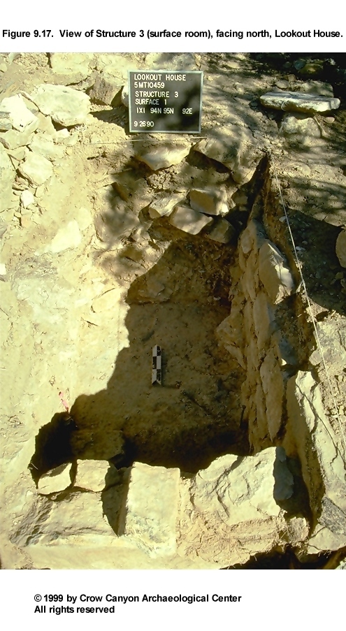
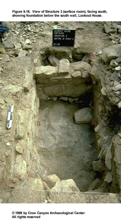
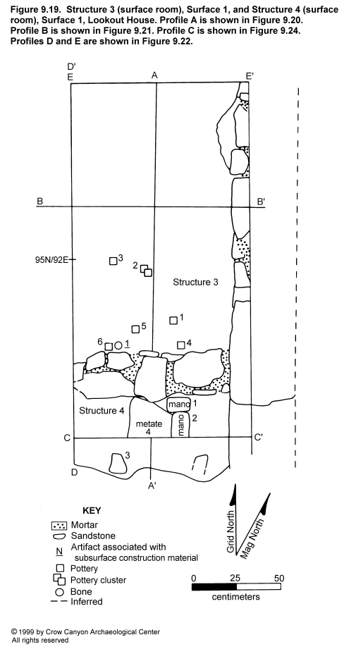
Construction
Architectural construction is described in this section, including the walls, roof, and floor surface (Figure 9.19, Figure 9.20, and Figure 9.21).
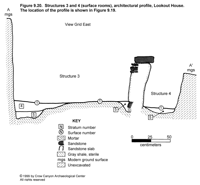
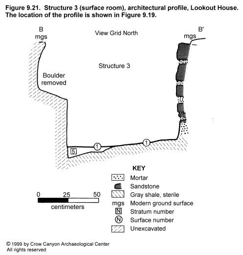
Walls. Excavations in Structure 3 exposed segments of the east and south walls. The exposed portion of the east wall is 1.54 m long and ranges from 59 to 76 cm high. Only 8 cm of width is observable, but the cross section is probably similar to that for the south wall (compound construction). The wall is semicoursed, and a maximum of seven courses survives. More than half the wall is constructed of unshaped sandstone, including one boulder at the base of the wall. Nearly one-quarter of the rocks have been pecked, and a limited amount of flaking was also noted.
Sandstone blocks make up the majority of the wall, although tabular and irregular pieces of sandstone are present as well. The wall rests on a foundation of undisturbed gray shale and, at the north end, decomposing sandstone. The mortar joints are 1 to 3 cm thick and contain few chinking stones. The mortar consists of a brown fine silty sand containing small sandstone bits, charcoal and calcium carbonate flecks, and in some places, pockets of platy gray shale and orange brown adobe. No plaster was noted. The south wall abuts this wall.
The description of the south wall applies only to the north face of the south wall. The south face will be described as the north wall of Structure 4. The south wall segment is 88 cm long, 55 to 59 cm high, and 27 cm wide. A boulder makes up approximately one-half of this wall. The remaining sandstone is block and tabular. A maximum of six courses is present in this wall. Construction is semicoursed vertically and compound in cross section. A shallow trench excavated into undisturbed shale contained a course of unshaped sandstone footing stones below Surface 1 in this wall (Figure 9.20).
Mortar joints in the south wall are 1 to 4 cm thick and contain a few chunk chinking stones. The mortar is the same as that described for the east wall. This wall abuts the east wall.
Roof. No direct evidence of roof construction was noted in Structure 3. The absence of a post hole in the only observable corner (southeast) of the room suggests that the roof was wall supported. Massive structural collapse in the room fill probably contains roof fall material (Figure 9.22).
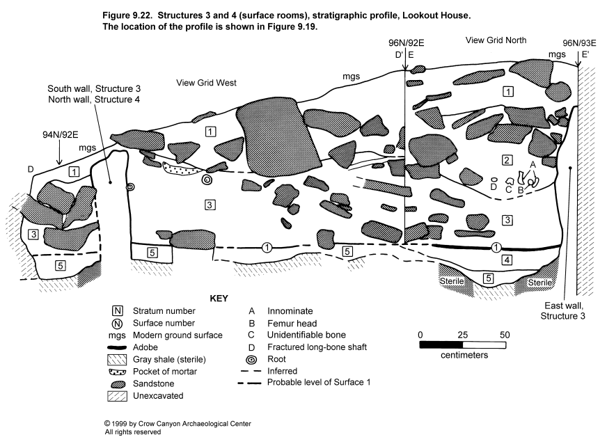
Surface 1. Surface 1 is the use floor in Structure 3. This surface was not uniformly prepared across the area examined. Apparently the room area was first cleared of sediment down to undisturbed, sterile sediment. Along the north edge of the excavated area, this consisted of decomposing sandstone. In the remainder of the excavated area, sterile consisted of gray shale. The east wall was constructed on top of the undisturbed shale or decomposing sandstone. The south wall was seated in a shallow trench that had been excavated into the shale.
In the southeast portion of Structure 3, there may have been no further floor preparation--postoccupational fill rested on the shale. The west half of the exposed floor was formed of construction fill placed on top of irregular shale to form a level surface. In the northeast area, two different strata of construction fill were used to bring the surface up to level with the remainder of the floor (Figure 9.20 and Figure 9.22). This was the only area where the remnants of an adobe surface survived. The construction fills are described in the Stratigraphy section below.
Surface 1
No features were defined on the limited area of floor surface exposed in Structure 3. The following artifacts were point-located on the floor and are thought to be incidental refuse (Figure 9.19): one Indeterminate Local Corrugated Gray jar body sherd (PL 1), five Indeterminate Local Corrugated Gray jar body sherds (PL 2), one Pueblo III White Painted jar body sherd (PL 3), one Indeterminate Local Corrugated Gray jar body sherd (PL 4), one Indeterminate Local Corrugated Gray jar body sherd (PL 5), and one Late White Unpainted bowl body sherd (PL 6). Artifacts recovered from the construction fill below Surface 1 include one bone bead (PL 1) (Figure 9.19), one Indeterminate Local Corrugated Gray sherd, two Pueblo III White Painted sherds, two Late White Unpainted sherds, and one piece of chipped-stone debris.
Stratigraphy
Two strata of construction fill and three strata of postoccupational fill were observed in Structure 3 (Figure 9.22). Stratigraphic profiles along the 96N grid line and the 92E grid line are illustrated in Figure 9.22. This illustration also includes the stratigraphy observed in the excavated portion of Structure 4. These deposits will be discussed from the modern ground surface down to undisturbed sterile sediments.
Stratum 1 is a dark yellowish brown fine sandy silt containing small to large unshaped sandstone rocks and sparse charcoal and calcium carbonate flecks. This stratum was naturally deposited after the site was abandoned. The rubble rests at too high an elevation to be wall fall rubble, unless it is from the north wall of this structure.
Stratum 2 is observable only in the north profile face. This deposit is a dark yellowish brown fine silty sand containing small to large, shaped and unshaped sandstone rocks (some of which are burned), dense charcoal flecks, and sparse calcium carbonate flecks. Wall collapse adobe is included in this somewhat mottled stratum. The mottling is probably a result of the mixing of Strata 1 and 3.
The mixing resulted from the prehistoric excavation and refilling of a pit associated with a human interment. The interment occurred after approximately 60 cm of fill had accumulated in this room. The location of the articulated human remains is illustrated in the north-facing stratigraphic profile (Figure 9.22). The large sandstone rocks forming a rough arc in the upper half of Stratum 2 are interpreted as being associated with the interment.
Stratum 3 is a yellowish brown fine sandy silt containing sandstone rocks from building-stone size to pebble size, some of which are shaped; sparse charcoal and calcium carbonate flecks and adobe mottling are also present. This deposit is structural collapse, including wall fall sandstone and melted adobe. Stratum 3 was truncated in the north profile wall by the excavation of the Stratum 2 burial pit.
Stratum 3 appears to have been naturally deposited after the room was abandoned. This material accumulated prior to the human interment, which indicates that the room was abandoned and had begun to collapse before the site itself was abandoned. Another possibility is that the burial is the result of postabandonment reuse of the site.
Stratum 4 is a strong brown silt loam containing sandstone and charcoal pieces up to 1 cm in diameter and sparse calcium carbonate flecks. This deposit is intentional construction fill designed to provide a level surface for the adobe floor. Remnants of this adobe surface were observed on top of Stratum 4 (Figure 9.22).
Stratum 5 is a very mottled, pale brown fine sandy silt. Within this sediment are flecks of charcoal, pockets of gray shale and unburned adobe, and small bits of red, yellow, and white sandstone. This deposit is a layer of construction fill designed to form a level foundation for Surface 1 in Structure 3, and it served the same function in Structure 4. Stratum 5 rests on undisturbed sterile gray shale and on decomposing sandstone.
Artifacts recovered from the excavated fill of this room include the following: 15 Indeterminate Local Corrugated Gray sherds; one Late White Unpainted sherd; one bone awl; one indeterminate chipped-stone tool; one ground-stone slab; human foot bones (see PL 2 under miscellaneous human bone from Lookout House, Chapter 19); nonhuman bone; and 45 pieces of chipped-stone debris.
Dating
No tree-ring samples were collected from Structure 3. The Pueblo III pottery recovered from the floor and the fill of the room provides the only direct means of dating this room. However, Structure 3 is assumed to be associated with the remainder of the architecture and with the midden deposits at the site. The few tree-ring dates available for this site indicate that some construction occurred sometime after A.D. 1257.
Interpretations
From the area of Structure 3 examined, this appears to be a sizable masonry surface room with well-constructed, well-preserved walls. Structures 3 and 4 were constructed at the same time, as the east walls of these two rooms are one continuous construction. There are few data on which to base a functional interpretation for the room; sparse artifacts and no features are associated with the floor. Whatever the function, Structure 3 may be associated with Structure 1 (kiva), which is 1 to 1.5 m to the east.
The presence of this room was undetectable at modern ground surface, in spite of the east wall being 76 cm high. That is, due to the substantial amount of sediment accumulation since site abandonment, the room was buried.
The room fill contains an intrusive human burial. This interment may have occurred after the room was abandoned but while the site was still occupied, or the burial may be evidence of postabandonment use of the site.
Structure 4 (Surface Room)
Structure 4 is a masonry surface room adjacent to Structure 3 to the south (Figure 9.23). A small area of Structure 4 was exposed in random unit 94N/92E and in a small judgment unit measuring 25 × 100 cm that was excavated to the south of that random unit in order to facilitate excavation (Figure 9.19). Short sections of the north and east walls were observable in these excavation units. Minimum dimensions for Structure 4 are 41 cm north-south by 87 cm east-west.
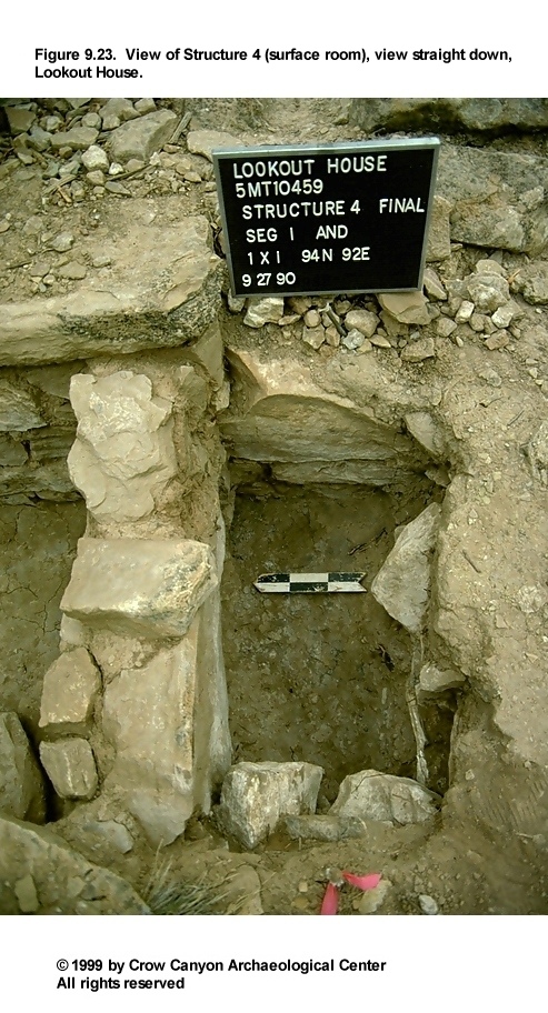
Construction
The architecture observed in Structure 4 is described in this section, including the walls, roof, and floor (Figure 9.19, Figure 9.20, and Figure 9.24).
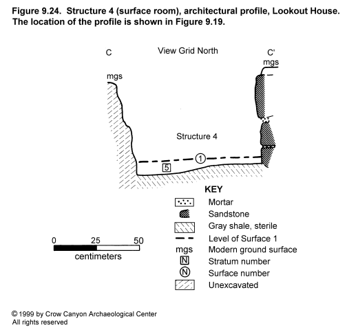
Walls. Excavations in Structure 4 exposed short sections of the north and east walls only. The description of the north wall applies to the south face of this wall; the north face was described under the Structure 3 heading.
The exposed portion of the north wall is 87 cm long, 62 to 71 cm high, and 27 cm wide. This wall is abutted to the east wall. It is generally of compound construction, although the section exposed is composed predominantly of one very large, unshaped sandstone slab (Figure 9.20). The presence of this slab gives the wall the appearance of being uncoursed; the smaller rocks in the wall merely fill the gap between the slab and the east wall. One stone in this face is minimally flaked.
The foundation of the north wall is undisturbed, sterile gray shale. The large slab apparently was set into a trench, as it continues down into the shale. The color and texture of the mortar and the thickness of the mortar beds are the same for this wall as for the south wall of Structure 3.
The exposed segment of the east wall is 41 cm long and 41 to 59 cm high; 12 cm of width was observable. The north wall of Structure 4 abuts this wall; both rest on a foundation of undisturbed gray shale. The east wall has three courses of semicoursed masonry composed of minimally shaped, irregular and tabular sandstone. The mortar in this wall is the same as that described for the east wall of Structure 3. A small amount of tabular chinking was observed in this wall.
Roof. There is no direct evidence of roof construction in Structure 4. The absence of a post hole in the northeast corner of the room, however, suggests that the roof was supported by the masonry walls rather than by upright posts. Stratum 3, as described in the Structure 3 Stratigraphy section, probably contains roof-collapse material, although no vegetal component was observed.
Surface 1. The occupation surface, or floor, of Structure 4 was constructed in the same way as the floor in Structure 3. The room area was cleared of sediment down to undisturbed gray shale. The masonry walls were then constructed, with the east wall resting on top of the shale and the north wall based in a shallow trench dug into the shale. Construction fill (see Stratum 5, Structure 3, Stratigraphy section) was placed on top of the shale to form a more level surface for the construction of the adobe floor. The exposed floor surface averages 5 to 10 cm lower than the exposed portion of the Structure 3 floor surface.
Surface 1
No features were observed in the small area of floor exposed in Structure 4. However, several artifacts were recovered that are probably associated with the use of the room.
Artifacts. Two two-hand manos (PLs 1 and 2) and one slab metate (PL 4) were recovered just above the floor. An additional mano (PL 3) was located near the south face of the excavation unit (Figure 9.19). The metate sloped steeply, and the grinding surface was on the underside, so this artifact was probably left leaning against the north wall. This suggests that these artifacts were being stored in this corner of the structure. This does not necessarily indicate that this is a storage room, because grinding tools could have been stored in a corner of a habitation room.
Stratigraphy
The stratigraphy in Structure 4 has been illustrated in Figure 9.22 and discussed in the Structure 3 Stratigraphy section above. It consists of subfloor constructional fill, an adobe floor surface, structural collapse, and postoccupational deposits. Artifacts recovered from the fill include the following:
-
Indeterminate Local Corrugated Gray sherds (22)
Mesa Verde Black-on-white sherds (6)
Pueblo III White Painted sherds (3)
Late White Unpainted sherd (1)
hammerstone (1)
polishing stone (1)
raw clay
abrader (1)
peckingstone (1)
complete bird bone (1)
pieces of chipped-stone debris (15)
Dating
As with Structure 3, pottery provides the only direct means of dating Structure 4. The pottery recovered from Structure 4 indicates that the room was abandoned during the late Pueblo III period. Tree-ring samples from other areas of the site could also help date these rooms, since all of the cultural deposits at the site are believed to be contemporaneous. The few dates available suggest that at least some construction at the site occurred after A.D. 1257.
Interpretations
Only a very small area of the northeast corner of Structure 4 was excavated. The room is masonry, probably rectangular, and a number of grinding tools recovered from the room appear to be associated with the use of the room. A metate leaned against the wall of the room in a stored, rather than a use, position. The presence of these tools may indicate that the room was used for storage, or it may indicate that grinding and other household activities occurred here. As with Structure 3, Structure 4 may be associated with Structure 1 (kiva), which is 1 to 1.5 m to the northeast.
Sampling Unit 88N/91E
This random test pit is south of Structures 3 and 4, near the edge of the architectural terrace (Figure 9.2 and Figure 9.3). The unit contains 30 to 70 cm of fill that rests on bedrock. A possible wall segment rested on the bedrock surface. This possible wall is described first, followed by a description of the stratigraphy in the unit.
Four large sandstone rocks roughly aligned east-west were noted just north of the center of the unit, resting on bedrock. The size of the rocks and the absence of shaping indicate that this would have been a retaining wall rather than a structure wall.
Stratigraphy
The sediment in this unit consists of postabandonment deposits, which are described from the modern ground surface down to bedrock.
Stratum 1 is 10 to 15 cm of brown sandy silt containing sparse, building-stone-size sandstone rocks. The boundary with Stratum 2 is abrupt and smooth. This deposit is the result of recent alluvial and colluvial deposition.
Stratum 2 is 16 to 42 cm of reddish brown to light reddish brown coarse sandy loam containing charcoal flecks, numerous small sandstone rocks, some building-stone-size sandstone, unburned adobe, and calcium carbonate flecks. The boundary with bedrock is abrupt and smooth. The rocks in this stratum could be wall fall from either Structure 4 to the north or from the possible wall in this unit. The reddish color of Stratum 2 could be from wall mortar.
Inner Periphery (Sampling Stratum 4) Summary
Four random units were selected for excavation in this sampling stratum (88N/91E, 94N/92E, 95N/92E, and 90N/119E). No excavation was possible in 90N/119E, as this unit consists of an exposed bedrock ledge. Testing in the remaining three units exposed portions of two masonry surface rooms (Structures 3 and 4) and part of a possible retaining wall (88N/91E). A small judgment test pit was excavated in Structure 4 for logistical reasons.
Although no function could be determined for Structures 3 and 4, Structure 4 contained several grinding tools in its northeast corner. These two structures may be associated with Structure 1 (kiva), which is immediately to the east.
Midden (Sampling Stratum 5, Nonstructure 1)
The midden at Lookout House was designated Sampling Stratum 5 (Figure 9.3). This unit covers 332 m². Twelve 1-×-1-m units were randomly selected for excavation. One of these 12 units will not be discussed further; random unit 86N/93E is located on a nearly vertical sandstone face. Thus, no cultural material was recovered from this unit. Unit 87N/101E contained a human burial, which was the only feature encountered in the midden. This burial is described below. Data from the remaining 10 random units are contained in Table 9.1.
Two judgment units (one 1 × 1.5 m, the other 50 × 60 cm) were also excavated in the midden. These units are adjacent to random unit 87N/101E, and they were excavated in order to fully expose the burial.
Feature 1 (Burial)
Feature 1 is the burial of what appears to be an adult male (Figure 9.25) (see also Chapter 19, Human Skeletal Remains). This body was interred near the north edge of the midden, at the base of a sandstone face. The body as positioned for burial was 87 cm long and 42 cm wide, and it extended 28 cm vertically. The body was flexed and oriented grid east-west, with the head to the west. The legs were tightly flexed in front (south) of the lower abdomen. The arms were beneath the upper torso.
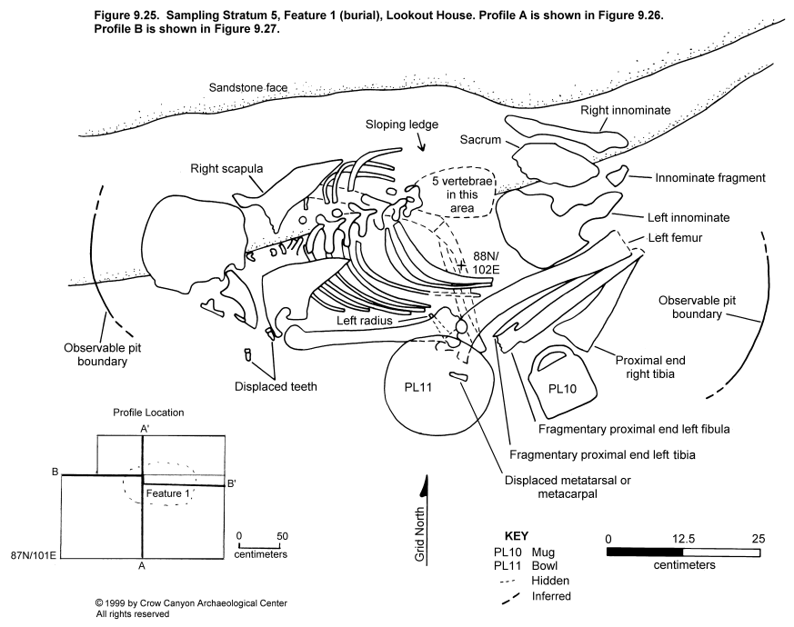
At the time of excavation, the body was face down, but this probably was not the position at the time of interment. The body probably originally rested, at least to some degree, on its right side. Evidence of this was noted in the nearly vertical position of the right scapula and right innominate, while the left scapula and innominate were horizontal. Also, the proximal end of the left femur was displaced downslope, or south of, the acetabulum in such a way as to suggest that the south side of the body had shifted in a rolling motion away from the sandstone face after interment. This would have been the result of the natural subsiding of sediment under the south side of the body and the stationary nature of the sandstone face and sloping ledge that the north side of the body rested on (Figure 9.26).
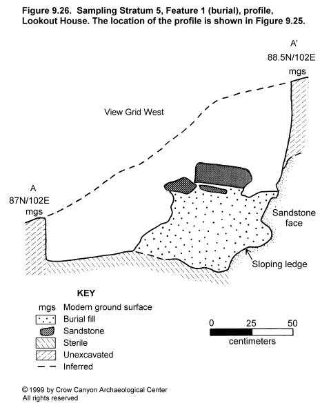
The body is complete, with the exception of carpals, metacarpals, phalanges, patellae, tarsals, metatarsals, and calcanei. The small extremity bones are often displaced or missing in burials, probably due to disturbance after interment. In the area of this burial, the midden was severely disturbed by animals (Figure 9.27).
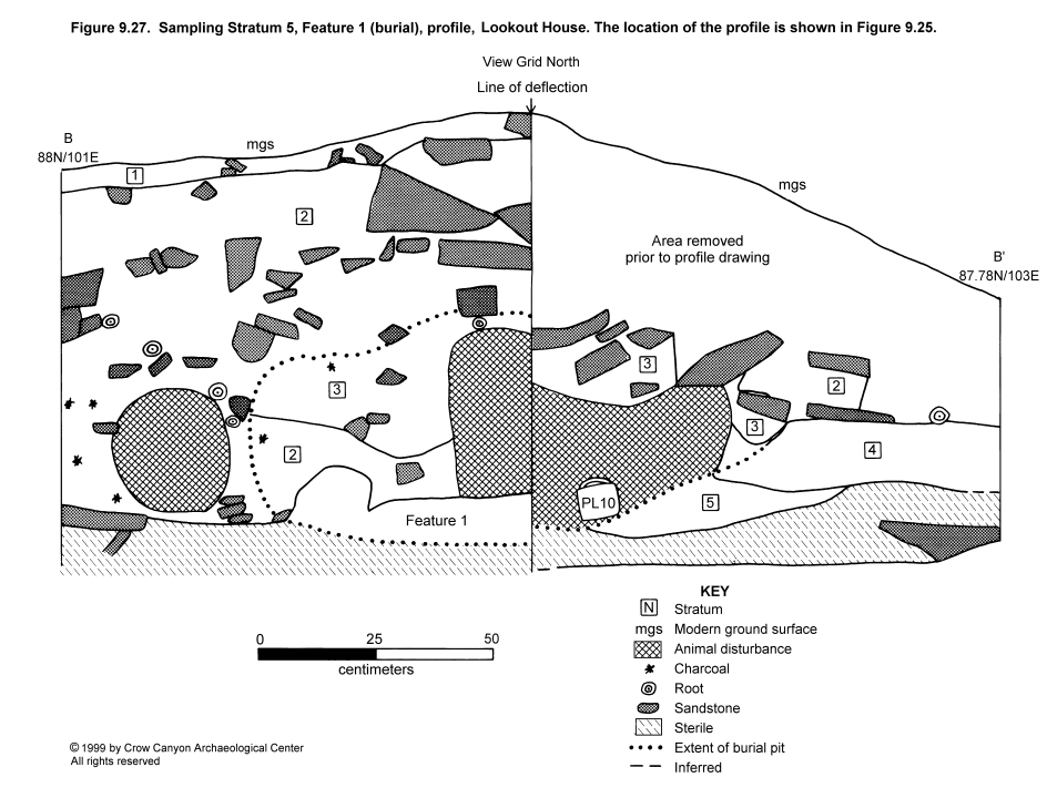
The bone itself is generally well preserved; however, the elements that were near or in contact with the sandstone face were badly decomposed. This may be the result of chemical deterioration or of moisture draining down the sandstone face.
Artifacts associated with the interment consist of a slab metate (PL 2), a complete Mesa Verde Black-on-white mug (PL 10), and a complete Pueblo III White Painted bowl (PL 11). The vessels were clearly intended as grave goods; however, the metate was above the skull and appeared to be serving the same function as the other large rocks that covered the body. A modified bone (PL 9), a bone awl (PL 17), and other miscellaneous artifacts were recovered from the fill of the burial pit, but these appeared to be associated with the midden rather than with the burial.
The burial pit boundaries were difficult to detect because of the large number of sandstone rocks and the considerable animal disturbance. However, it was apparent that the burial pit had been excavated through midden fill and extended a short distance into undisturbed sterile sediments below the midden. The body and grave goods were then interred, and the pit was refilled with the same sediments. Large rocks were subsequently piled above the filled pit.
The burial pit appears to have been excavated through approximately 40 vertical centimeters of midden deposits, so interment evidently occurred after that amount of midden had accumulated in this area. At least 25 cm of midden deposits accumulated above the grave after the body was interred.
One pollen and one flotation sample were taken from sediment in the area of the left ribs. Additional pollen samples were collected from beneath the bowl (PL 11) and beneath the mug (PL 10) associated with the burial. The sediment from inside the mug was dry-screened, after which a pollen wash was taken from the mug interior.
Stratigraphy
Burial-associated stratigraphy is described in this section. This includes stratigraphy in random unit 87N/101E and in judgmental unit 87N/102E (Figure 9.27). These deposits are described from the modern ground surface down to undisturbed sterile sediment.
Stratum 1 is a powdery, brown sandy silt containing sandstone, sparse calcium carbonate flecks, and decomposing organic material. This is recent, naturally deposited, postabandonment sediment.
Stratum 2 is a dark grayish brown sandy loam containing sandstone, artifacts, and charcoal and calcium carbonate flecks. This stratum is secondary refuse deposited during the occupation of the site. A layer of this stratum was redeposited into the burial pit after the body was interred.
Stratum 3 is a reddish brown sandy loam containing pieces of sandstone and flecks of charcoal and calcium carbonate. The rocks covering the burial are resting on this material, which appears to be redeposited sterile sediment. However, it is not clear why this material and Stratum 2 (redeposited midden) did not become mixed during the excavation and refilling of the burial pit.
Stratum 4 is a dark grayish brown fine sandy silt containing numerous small sandstone rocks and sparse calcium carbonate flecks. This material is probably undisturbed secondary refuse outside the burial pit.
Stratum 5 is a reddish brown fine sandy silt containing a few tiny charcoal flecks and sandstone rocks. This stratum was deposited during the occupation, prior to the use of this area for the deposition of secondary refuse. This material rests on undisturbed sterile sediment (red brown sandy loam), which was probably the prehistoric ground surface at the beginning of the site occupation.
In summary, after 30 to 40 cm of secondary refuse had accumulated during the occupation of the site, a pit was excavated through these deposits and a short distance (10 to 20 cm) into undisturbed sterile material. An adult human body and associated grave goods were then placed in the pit. First the midden material and then the sterile deposits were used to fill the remainder of the pit, and large sandstone rocks and slabs were piled on top of this backfill to complete the burial. Approximately 25 cm of additional secondary refuse accumulated above the rocks during the remainder of the site occupation.
Midden (Sampling Stratum 5, Nonstructure 1) Summary
Twelve random 1-×-1-m units were selected to sample the midden. One of these was occupied by exposed sandstone bedrock. The remaining 10 units contained either one or two strata of cultural material. The two strata encountered were slopewash and intact midden deposits. The term slopewash is meant to indicate that cultural material is present, but the material is not believed to have been originally deposited in that location. However, even for the intact midden deposits, some downslope creep is assumed to have occurred; the slope of modern ground surface ranged between 18 and 37 degrees in these units.
Three of the units (83N/91E, 75N/94E, and 91N/110E) contained only slopewash. The others contained either one stratum of midden or a stratum of midden covered by a layer of slopewash. The deepest midden deposit observed (70 cm) was in the northern portion of unit 87N/101E.
Cultural deposits rested on either sandstone bedrock or on undisturbed sterile sediments. The sterile sediments ranged from reddish brown to light brown and from coarse sand to silty clay loam in texture. All contained sandstone inclusions.
Many artifacts were recovered during test excavation in Sampling Stratum 5. Analytical data for these are summarized in tables at the end of this chapter.
The only feature documented in the midden was the burial of an adult human in unit 87N/101E. The body and associated grave goods were interred in a pit after 30 to 40 cm of secondary refuse had accumulated in that area. Rocks were piled on the backfilled pit, and another 25 cm of secondary refuse accumulated before the site was abandoned.
Outer Periphery (Sampling Strata 6, 7, and 9)
These three outer periphery strata are downslope from the midden (Figure 9.3), and they were sampled to discover the amount of downslope artifact movement at steeply sloping sites. Sampling Stratum 6 covers 240 m² and was sampled by randomly selected units 74N/90E, 73N/103E, 75N/114E, and 80N/110E. Sampling Stratum 7 is 448 m². The following units were randomly selected for excavation: 68N/90E, 64N/94E, 69N/102E, and 55N/114E. Sampling Stratum 9 covers 441 m² and was sampled by randomly selected units 36N/110E, 37N/111E, 46N/114E, and 49N/110E. Excavation of these units was completed in 1990. No judgment units were excavated in the outer periphery strata, and no features were encountered.
Table 9.2 presents a summary of the data for the random units excavated in Sampling Strata 6 and 7. All of these units contained slopewash; the depth of the deposits varied from less than 5 cm to as much as 50 cm. The slope of the modern ground surface ranged between 16 and 26 degrees in these units. Types of undisturbed sterile encountered beneath cultural deposits include the following: sandstone bedrock, Morrison Formation shale, and red brown silty clay loam.
Sampling Stratum 9 can be summarized as follows. The one stratum of cultural material observed is slopewash. This sediment grades from brown to red brown to dark brown and from sandy loam to sandy clay loam. The only inclusions noted were sandstone rocks and sparse calcium carbonate flecks. This deposit is as much as 32 cm deep in the two northern units (46N/114E and 49N/110E) and as shallow as a few centimeters deep in the two southern units (36N/110E and 37N/111E). Artifacts were present, but sparse, in all of the units. The sterile sediments beneath the slopewash consist of red brown sandy loam to sandy clay loam.
Outer Periphery (Sampling Stratum 8)
This outer periphery sampling stratum includes the east and west boundaries of the artifact scatter at Lookout House (Figure 9.3) and covers 235 m². Four 1-×-1-m units were randomly selected to sample this area: 91N/86E, 97N/87E, 99N/85E, and 79N/119E. No judgment excavation occurred in Sampling Stratum 8, and no features were detected. The slope of the modern ground surface ranges between 16 and 26 degrees.
Very few artifacts were recovered from these test pits. Material above the undisturbed sterile sediment consists of 10 to 55 cm of brown to reddish brown sandy loam containing sandstone but few other inclusions. Below this stratum is undisturbed, sterile sediment of either finer-grained, more compact, reddish brown sediment, or gray shale.
Lookout House Artifacts
Artifact data for Lookout House are presented in Table 9.3, Table 9.4, Table 9.5, Table 9.6, and Table 9.7. These data suggest that there was a single, late Pueblo III occupation and that the site functioned as a year-round habitation.
The greatest numbers of artifacts were collected from Sampling Stratum 1 and Sampling Stratum 5. This is because these strata contained midden deposits. Sampling Stratum 1 contained the refuse in Structure 7 (kiva), and Sampling Stratum 5 consisted of the refuse deposits downslope. Sampling Stratum 1 yielded more artifacts, probably because the refuse in Structure 7 was buried beneath postabandonment structural collapse and so was protected against collection in prehistoric, as well as recent, times.
The pottery recovered from the site is almost exclusively Pueblo III. Few of the sherds recovered predate the Pueblo III period (one Early White Unpainted, two Mancos Black-on-white, and two Pueblo II White Painted); these are too few to represent an earlier component. Pueblo III decorated white wares are well represented and include the following: McElmo Black-on-white (21 sherds), Mesa Verde Black-on-white (175 sherds), and Pueblo III White Painted (795 sherds). These sherds make up 99.7 percent of the decorated white ware sherds recovered from the site. Of the corrugated sherds assignable to type (N = 45), six (13 percent) are Mancos Corrugated and 39 are Mesa Verde Corrugated. Again, the percentage of earlier corrugated sherds is small, and probably does not indicate a separate component. Also recovered were three Tsegi Orange Ware sherds and one Kiet Siel Polychrome sherd. The former dates to approximately A.D. 1150-1300 and the latter to approximately A.D. 1250-A.D. 1285. Thus, the overwhelming predominance of Pueblo III pottery in the overall assemblage strongly indicates that this site is probably the result of one occupation that occurred during the Pueblo III period.
Other artifacts recovered from the site include stone tools, modified sherds, chipped-stone debris, nonhuman bone (including bone tools), mineral samples, beads, and gizzard stones. The following complete and fragmentary tools were collected:
-
metates (4)
manos (7)
abraders (2)
peckingstones (7)
polishing stones (4)
projectile points (4)
bifaces (6)
cores (12)
axes (2)
modified flakes (15)
awls (7)
drill (1)
modified sherds (30)
shaped sherd (1)
In addition, 1,663 pieces of chipped-stone debris, numerous nonhuman bones (see Chapter 18, Faunal Remains), three beads, three fragments of eggshell, three gizzard stones, unmodified petrified wood, shell, and hematite were recovered. One nearly complete human skeleton and miscellaneous human bone were also collected (see Chapter 19, Human Skeletal Remains).
A small number of artifacts from the site were identified as being of nonlocal origin or material. Four sherds (less than 1 percent of the site total) were identified as nonlocal--all from northeastern Arizona. Three of these are Tsegi Orange Ware (A.D. 1150-1300) (Colton and Hargrave 1937:92; Breternitz 1966:98). The fourth nonlocal sherd is Kiet Siel Polychrome, which dates to approximately A.D. 1250-1285 (Breternitz 1966:80).
Other materials recovered that are of nonlocal origin include petrified wood, Washington Pass chert, obsidian, and nonlocal chert/siltstone. Four pieces of petrified wood were collected; one is modified and may have been part of a pendant originally. Petrified wood is common in northwestern New Mexico and southeastern Utah. One modified flake and three chipped-stone debris fragments of Washington Pass chert were identified. Washington Pass is west of Chaco Canyon in northwestern New Mexico. Nine fragments of nonlocal chert/siltstone chipped-stone debris and one obsidian flake were also recovered. The origins of these materials are not known, but the nearest obsidian source is Polvadera Peak in north-central New Mexico.
Only a few artifacts of nonlocal origin were collected during testing of Lookout House. However, some regional exchange with northeastern Arizona and northwestern New Mexico is suggested by the presence of these items.
Site Summary and Conclusions
Lookout House is a late Pueblo III, cliff-face/talus-slope habitation site located just below the north rim of Sand Canyon, 150 m southwest along the canyon rim from Sand Canyon Pueblo. The site architecture sits on a narrow, sloping terrace, and the main midden covers the talus slope below. The site includes three kivas, a number of masonry surface rooms, a tower, a subterranean masonry-lined room, middens, and numerous retaining walls. Forty-five random 1-×-1-m pits and a small number of judgment units were excavated to test the site.
The major cultural units identified through testing include three kivas (Structures 1, 2, and 7), two masonry surface rooms (Structures 3 and 4), a subterranean masonry-lined structure (Structure 6), several sections of retaining walls (Sampling Stratum 1, Feature 2; Sampling Stratum 3, Features 3, 5, and 7), and two midden areas (Nonstructures 1 and 2). All are believed to be the remains of one occupation, although there is evidence that not all of the structures were in use at the same time. Structure 7 (kiva) apparently was constructed early in the occupation, then was abandoned, dismantled, and filled with refuse. A retaining wall (Sampling Stratum 1, Feature 2) was then constructed on top of the refuse fill, and additional refuse accumulated east of the wall.
The excavation of four random test pits in the surface architecture (Sampling Stratum 1) exposed portions of Structure 6 (a subterranean room), Structure 7 (a kiva), and Feature 2 (a retaining wall). Also observed, but not tested, was Structure 8, which is interpreted to be the remains of a tower on the cliff above the site.
Structure 6 is a well-preserved, rectangular, masonry-lined subterranean room of unknown function. Only the northeast corner of the room was excavated. It could be a mealing room associated with either Structure 2 (kiva) or Structure 7 (kiva), and it may be connected by a tunnel to either of those kivas. The absence of vegetal material in the roof fall stratum suggests that the timbers were salvaged. The naturally deposited fill indicates that the site was abandoned at the same time that Structure 6 was abandoned.
Structure 7 is an unburned, masonry-lined kiva that underwent substantial dismantling while use of the site continued. In the small area exposed, only a few courses of curved, bench-face masonry were intact. The curvature of this masonry, the depth of the floor below the prehistoric ground surface, and the preparation of the floor, led to the interpretation that the structure was a kiva. This structure may be associated with Structure 6 (subterranean room) adjacent to the west. The absence of rotted vegetal material in the roof fall suggests that the roofing timbers were salvaged.
After the roof collapsed, ashy midden (Nonstructure 2) was deposited into the kiva depression. A tree-ring sample from the lower levels of this refuse fill yielded a date of A.D. 1257 v, which indicates that the structure dates to the same mid- to late A.D. 1200s occupation as the other architecture and refuse at the site. This date is the latest of the three tree-ring dates obtained for this site, and it is substantiated by the presence of a Kiet Siel Polychrome sherd in the same deposit. This nonlocal pottery type is believed to date to A.D. 1250-1285 (Breternitz 1966:80). After a substantial amount of trash had accumulated, a massive retaining wall (Feature 2) was constructed on top of this fill, and trash was deposited east of this wall.
Two additional kivas and a kiva-associated section of retaining wall were defined in the pit structures sampling stratum (Sampling Stratum 2). Structure 1 (kiva) is a shallow, unburned, masonry-lined kiva. Features documented in this kiva include the hearth, deflector, ventilator tunnel opening, and bench face. On the west edge of the kiva, a section of retaining wall was observed. This is a rough, low wall that appears to have been used to stabilize the area surrounding the kiva.
Structure 1 may be associated with Structures 3 and 4, which are masonry surface rooms immediately to the west. It may also be associated with a structure that might exist to the southeast. The existence of a structure is suggested by a section of finely constructed masonry wall with a possible doorway in that area (see Sampling Stratum 3, Features 4 and 8).
The absence of vegetal material in the roof fall stratum is interpreted as evidence that the timbers were salvaged when the structure was abandoned. The absence of trash in the structure fill indicates that Structure 1 was abandoned at the same time as the remainder of the site.
Structure 2 (kiva) is an unburned, masonry-lined kiva. Three random units and two judgment units exposed areas of floor surface, Benches 3 and 5, Pilasters 3, 5, and 6, and a niche. Two human burials were also discovered but left in place.
Structure 2 may be associated with undefined masonry surface rooms to the northwest or with a masonry-lined subterranean room to the east. The kiva could be connected by tunnel to any of those structures.
The absence of vegetal material in the roof fall stratum suggests that the roofing timbers were salvaged when Structure 2 was abandoned. The absence of trash in the fill indicates that the structure was abandoned at the same time as the remainder of the site; however, the two burials indicate that the site was used after the structures were abandoned.
The four random units and one judgment trench in the courtyard (Sampling Stratum 3) encountered several features: three small burned spots that appear to represent single events on prehistoric ground surface, four segments of masonry walls, and one possible doorway. Three of the walls appear to be retaining walls, but the function of the fourth, more finely constructed wall (Feature 4), is unknown. It is this wall that includes a possible doorway (Feature 8). This wall may belong to a structure associated with Structure 1 (kiva).
In the inner periphery (Sampling Stratum 4), testing encountered two masonry surface rooms (Structures 3 and 4). These adjacent rooms are in an area that was thought to be west of all architecture at the site, and so the area was not assigned to the surface structure sampling stratum. Sections of east and south walls and a sizable area of floor were exposed in Structure 3. The function of the room is unknown, however. Postoccupational collapse and filling of the room occurred naturally, except for a human interment in the fill, which indicates use after the room was abandoned.
Although only a very small corner of Structure 4 was exposed during testing, it was enough to establish the contemporaneity of this structure with Structure 3; their east walls are one continuous construction. Testing also encountered a number of grinding tools that were being stored in this corner, suggesting either that the room was used for storage or that grinding occurred there. Structures 3 and 4 may be associated with Structure 1 (kiva) immediately to the east.
Twelve random and two judgment test pits were excavated in the Nonstructure 2 midden (Sampling Stratum 5). As much as 70 cm of secondary refuse accumulated during the occupation of the site, although the average depth was much shallower. One feature, the burial of an adult human, was documented in the midden. The burial occurred midway through the occupation of the site.
Testing in the outer periphery (Sampling Strata 6, 7, 8, and 9) consisted of the excavation of 16 random units. The downslope test pits contained artifacts that, since their original deposition, had probably moved some distance down the slope. The outer periphery data should help to assess the amount and type of downslope artifact movement that occurs on steeply sloping sites in general and will help to estimate the amount of downslope artifact loss that Lookout House, in particular, has suffered.
The data indicate that Lookout House was a habitation site dating to the late Pueblo III period. Evidence of habitation includes kiva and surface-room architecture, extensive landscaping using retaining walls, and at least two midden areas that contain a large number and wide variety of artifacts.
The best indication of time of site occupation is the latest tree-ring date obtained--A.D. 1257 v. This sample was recovered from the earliest refuse deposits in Structure 7, which is a midden-filled kiva that is known to have been abandoned prior to overall site abandonment. Also, Mesa Verde Black-on-white pottery sherds are relatively abundant on the site and are present even near the floor of this structure. Lookout House is thus thought to have been occupied in the mid- to late A.D. 1200s and was probably contemporaneous with Sand Canyon Pueblo. However, it is thought that the site was abandoned prior to the abandonment of Sand Canyon Pueblo and of the region as a whole, for two reasons. First, there is no evidence of roofing timbers in the roof fall of any of the six structures tested; this is believed to be the result of salvaging of timbers at abandonment for new construction nearby. Second, three of the four burials encountered at Lookout House are in naturally deposited structure fills indicating that Lookout House had been abandoned, but that people were still living nearby.