7
Troy's Tower
Mark D. Varien
Contents
- Area North of the Tower (Sampling Stratum 2)
Troy's Tower Summary and Interpretations
Introduction
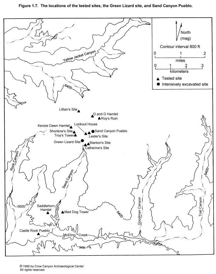
Troy's Tower was initially recorded during the 1986 Crow Canyon survey as CC86-16 (Van West et al. 1987) and was subsequently assigned site number 5MT3951. Troy's Tower sits on the high point of the mesa overlooking Sand Canyon at an elevation of 2120 m (6954 ft). Troy's Tower is 100 m south of Shorlene's Site and approximately 1 km (.6 mi) southwest of Sand Canyon Pueblo (Figure 1.7).
The spring at Sand Canyon Pueblo is the closest permanent water source. The site lies on the edge of the agriculturally productive Witt Series soils. Troy's Tower lies just south of a modern agricultural field that is currently fallow. Vegetation on the site is pinyon-juniper woodland that partially burned in a historic-period fire. A road was bulldozed through the west side of Troy's Tower as a part of the installation in the 1950s of a carbon dioxide well located south of the site.
Troy's Tower is smaller than the other tested sites and does not have a masonry roomblock. For these reasons, Troy's Tower does not fit the normative site layout associated with unit pueblos. The purpose in testing Troy's Tower was twofold. First, we wanted to sample the variation present in small site layout in the Sand Canyon locality. Second, Troy's Tower appeared to provide an opportunity to sample burned structures--fired adobe with vegetal impressions lay on the modern ground surface, indicating the presence of burned contexts beneath the surface.
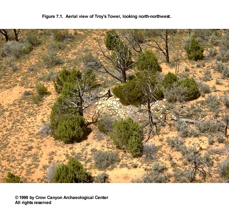
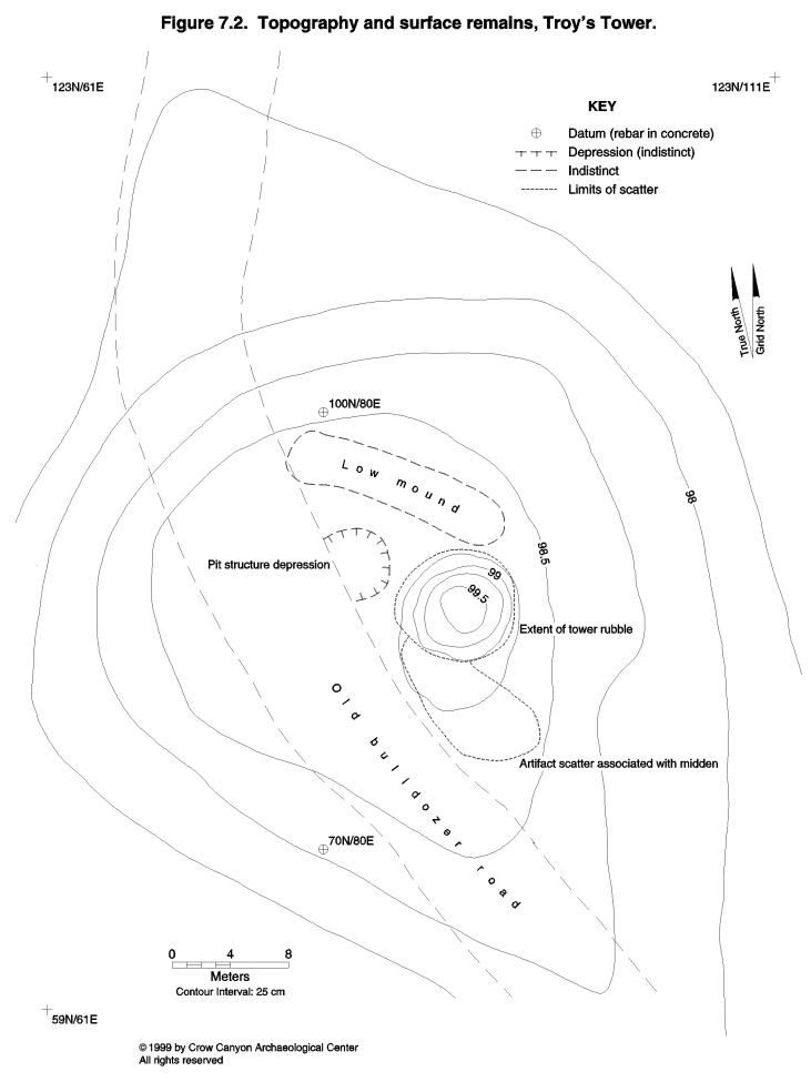
Surface remains at Troy's Tower include a masonry tower, a shallow depression west-northwest of the tower, a low topographic mound north of the tower, a small but dense artifact scatter immediately to the south of the tower, and a light artifact scatter surrounding the tower (Figure 7.1 and Figure 7.2).
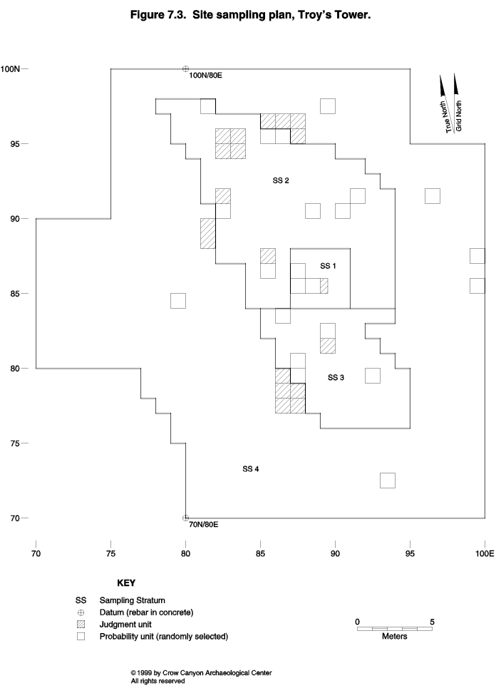
Surface remains provided the basis for drawing sampling stratum boundaries. The tower was the most obvious cultural feature, and this became Sampling Stratum 1 (Figure 7.3). The shallow depression and low topographic mound to the north of the tower were subtle, but it was thought that they might represent architectural features. Therefore, an area north of the tower became Sampling Stratum 2. The dense artifact scatter south of the tower had sharp boundaries, and this became Sampling Stratum 3. Finally, the light artifact scatter that surrounds all of these features was defined as Sampling Stratum 4, the outer periphery.
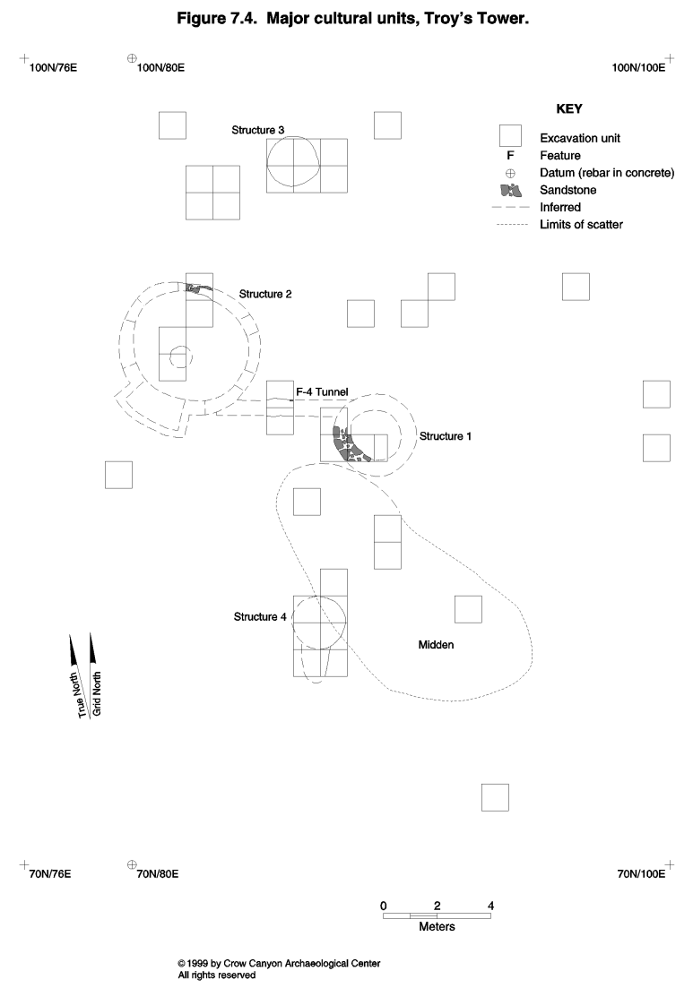
Testing at Troy's Tower began during the 1988 field season and was completed during the 1989 field season. Testing included the excavation of 38 1-×-1-m grid squares; 22 were randomly selected sampling units, and 18 were judgmentally located test pits. The tower (Structure 1), a masonry-lined pit structure (Structure 2), and a tunnel connecting the tower and the pit structure were located within these sampling units (Figure 7.4). Two large pits were also tested and were provenienced as Structures 3 and 4. In addition, the midden and outer periphery were sampled with a combination of randomly selected and judgmental pits. All of the cultural features tested are believed to date to the Pueblo III period.
The absence of both a roomblock and a large, deep midden indicates that Troy's Tower was not used in the same way as the other unit pueblos. Troy's Tower is believed to be a site that was used seasonally, or a site that served a more specialized function than daily habitation, or a habitation site that was used by an atypical household. Site use at Troy's Tower is discussed further in Chapter 22.
The Troy's Tower grid is aligned with magnetic north (13.5º east of true north). The vertical datum on Troy's Tower was a nail driven into the base of the juniper snag located on top of the tower. As at all the tested sites, an arbitrary elevation of 100 m was assigned to this vertical datum. Additional vertical data were recorded on the rebar used on the grid baseline.
Tower Rubble (Sampling Stratum 1)
This sampling stratum encompasses the masonry tower, Structure 1. The tower was built on a knoll on one of the highest points on the McElmo Dome. Even today, the fallen structure is a striking feature, with a juniper snag and an enormous ephedra bush growing out of the top. Climbing the juniper tree provides a commanding view in all directions. Clearly visible from the top of the tower is an architectural unit and reservoir associated with the southeasternmost portion of Sand Canyon Pueblo. The tower at Stanton's Site is also visible. Sampling Stratum 1 has 16 sampling units, three of which were excavated (85N/88E, 85N/87E, and 86N/87E). A small judgment segment was also excavated inside the tower to enable excavators to reach the floor.
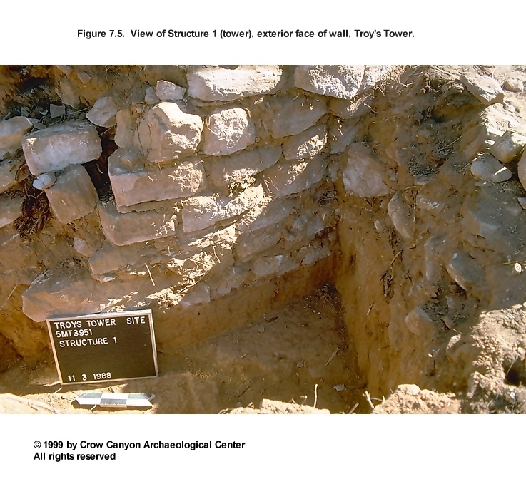
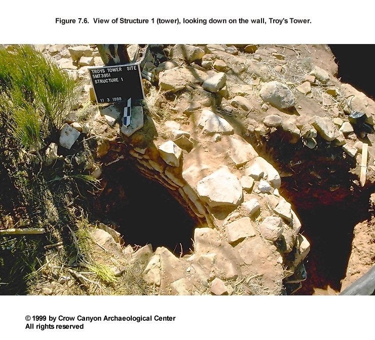
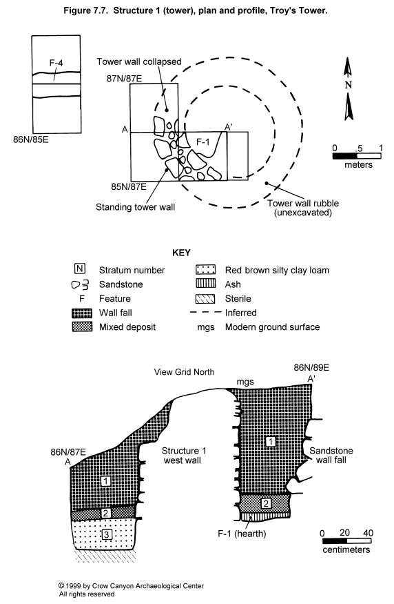
Structure 1 (Tower)
Two sampling units exposed the top and exterior of the Structure 1 wall (85N/87E and 86N/87E), and the third unit (85N/88E) fell partly within the tower (Figure 7.5, Figure 7.6, and Figure 7.7). Artifacts recovered from outside the tower were provenienced as Sampling Stratum 1; material from inside the tower was provenienced with Structure 1. The rubble mound associated with Structure 1 measures approximately 8.0 m in diameter and stands over 1.0 m high. The interior diameter of the structure is estimated on the basis of the exposed wall segment to be approximately 3 m.
Construction
Walls. Structure 1 has massive double-stone-with-core walls that measure 69 cm thick. The maximum wall height was 1.02 m; the minimum was 69 cm. The wall stones were semi- to fully coursed. Light pecking and flaking are present on many of the wall stones, but intensively shaped, pecked-block masonry is not present. There is no footer at the base of the wall. Instead, Structure 1 rests on a 22-cm-thick stratum of red brown silty clay loam that appears to be redeposited sterile B-horizon sediment. This redeposited sterile may have come from backdirt produced by the excavation of the pit structure, Structure 2. This stratum further enhances the natural high spot that the tower rests upon.
Stones are set in mortar joints 1 to 2 cm thick. A few of the thicker joints are chinked. Mortar varies, ranging from a red brown silty clay loam that resembles sterile B-horizon sediments to a coarser, strong brown silt to fine sandy loam. Signs of intensive burning were observed on the mortar on the inside surface of the wall. It is not clear if the mortar burned because of its proximity to a floor hearth set up against the wall, or if it burned as a result of a fire associated with the abandonment of Structure 1.
Floor. The floor of Structure 1 was a prepared adobe surface. A 3- to 8-cm-thick ash lens covered the floor. Beneath the ash, the floor adobe was oxidized. Because only a small portion of the floor was exposed during excavation, interpretations are limited. A shallow depression in one corner of sampling unit 85N/88E appears to be a hearth.
Feature 1 (Hearth): This feature is a shallow, basin-shaped depression containing ash. The ash was 8 cm thick in the center of the hearth and spilled out to cover all of the floor exposed in the sampling unit. The maximum depth of the depression in the floor is 5 cm, and the exposed portion measures 47 × 36 cm. The depression is so shallow and gradual that the edges of the hearth are not clearly defined; the depression slopes up gently to become the floor. The ash fill extends beyond the limits of the shallow depression.
Fire had oxidized the center of the hearth. The masonry wall adjacent to the ash-filled depression was blackened with soot. The fire also had baked the mortar up to the top of the standing wall.
Given the limited test excavations, it is difficult to determine the hearth's function and when it was used. The depression is so shallow that it does not appear to be a formal hearth that was part of the original construction; instead, this may be a hearth that was used only late in the structure's use history. Alternatively, the ash may be the result of a fire associated with the abandonment of the tower.
Ash from inside and outside the slight depression was sampled and contained virtually the same botanical remains (see Chapter 16). Charcoal recovered from the ash in the hearth and the ash covering the floor includes serviceberry/squawapple-type wood, mountain mahogany, Mormon tea, sagebrush, juniper, pine, and bitterbrush/cliffrose-type wood. In addition, vegetative parts of sagebrush, mountain mahogany, juniper, pine, and corn were found in the ash covering the floor. Reproductive plant parts recovered include a corn kernel, groundcherry, purslane, stick-leaf, winged pigweed, and cactus. A charred domestic wheat seed was also found in the hearth flotation samples, indicating that historic-period mixing has occurred (possibly during excavation). This mixing makes interpretation of the flotation samples from this hearth suspect, but the wide variety of economic plants recovered suggests that Feature 1 functioned as a food-processing feature.
In addition to the botanical remains, several artifacts were recovered from the fill of the hearth. These include a stone bead, eggshell, a corrugated sherd, a Late White Unpainted sherd, and several pieces of chipped-stone debris.
Additional excavation would have improved our interpretation of this feature. It would be critical to know if the ash centers in the area of the depression, or if it covers the entire floor of the tower. The lack of formal construction (for example, a well-defined pit in the floor) may indicate that the hearth was not a permanent facility on the Structure 1 floor and perhaps was used only sporadically. The food-processing activities, inferred on the basis of the economic plant remains found in the ash, may be associated only with the last use of Structure 1. If the ash covered the entire tower floor, then it may have been the result of a fire associated with the abandonment of the structure.
Roof. Testing found no evidence of roof timbers, burned or unburned. The burned and unburned adobe, and the compacted red sediment found in the fill above the floor, may be collapsed roof, or it may be mortar from the walls. The absence of a thick stratum of roof fall suggests that either the tower was not roofed or the roof materials were salvaged when the structure was abandoned.
Stratigraphy
As noted above, an ash lens covers the floor of Structure 1. It is not clear if this ash lens is primary refuse associated with the hearth or if it is ash from a fire associated with the abandonment of Structure 1. The floor and mortar oxidation suggest that a fire was built directly on the floor and that flames baked the walls.
Above the ash lens lies a 17-cm-thick stratum containing a mixture of burned and unburned adobe, compacted red sediment, charcoal, and pockets of ash (Stratum 2 in Figure 7.7). This material may represent sediments used in the tower construction, possibly from the roof. Wall fall, 88 cm thick, filled the remainder of Structure 1 (Stratum 1). A mano fragment was found in the wall fall inside the structure; another mano fragment, a projectile point fragment, a piece of modified bone, and two modified flakes were recovered from the wall fall outside the structure.
Dating
No charcoal in the fill of Structure 1 was large enough to collect for tree-ring analysis. The dating of Structure 1 therefore depends on construction style and the types of pottery found in the fill and on the floor; both suggest a late Pueblo III date. Mesa Verde Black-on-white is present in the upper wall fall stratum, and Late White Painted with carbon paint is present in the ash above the floor. A corrugated sherd was recovered from the hearth fill. A tunnel connects the tower (Structure 1) with the kiva (Structure 2), and archaeomagnetic and pottery dating indicate that the occupation of Structure 2 postdates A.D. 1225.
Structure 1 Interpretations
Structure 1, a masonry tower, is the main architectural feature visible on the surface of Troy's Tower. The tower was built on a high point from which the towers at Sand Canyon Pueblo and Stanton's Site are visible. These towers could have been part of a system of structures to permit communication between sites. In addition, the use of a tunnel to link the tower and the kiva suggests that the use and meaning associated with these two types of structure was somehow related.
The portion of the tower floor that was exposed in the test pit was covered with ash. The ash contained charcoal from numerous taxa interpreted as fuel, as well as the charred reproductive parts of numerous economic plants. These botanical remains suggest that the ash is the primary refuse of a food-processing activity area. The ash was not confined to a formal hearth, and this food-processing activity area may be associated only with the last use of Structure 1. Additional excavation perhaps would clarify the interpretation of Structure 1 and the events associated with its abandonment.
Area North of the Tower (Sampling Stratum 2)
Sampling Stratum 2 is the sampling stratum north of the tower. Architectural units should be located in this area, according to the normative model of habitation site layout (Prudden 1903, 1914). Surface remains were subtle; a shallow depression less than 20 cm deep and a low topographic mound 20 cm high were the main Sampling Stratum 2 surface features. Artifacts were scarce, and architectural debris was almost absent in this area. A total of 126 sampling units fell within Sampling Stratum 2; eight were excavated as part of the probability sample (97N/81E, 95N/85E, 95N/86E, 91N/91E, 90N/90E, 90N/88E, 90N/82E, and 86N/85E), and an additional six judgmentally located squares were excavated as well (94N/82E, 94N/83E, 95N/82E, 95N/83E, 91N/82E, and 87N/85E). Four more judgment units located in Sampling Stratum 4 (95N/87E, 96N/85E, 96N/86E, and 96N/87E) were excavated to allow us to completely define a large, bell-shaped pit (Structure 3) initially discovered in Sampling Stratum 2.
Excavation of the randomly selected units resulted in the discovery of two pit structures, Structures 2 and 3, and two pit features. The judgmentally located units were excavated for two reasons. First, the placement of several test pits adjacent to randomly located sampling units improved the excavation and interpretation of Structures 2 and 3. Second, we wanted to look for jacal rooms in a block of four contiguous test pits between Structures 2 and 3. However, these excavations found no evidence of surface rooms.
Structure 2 (Kiva)
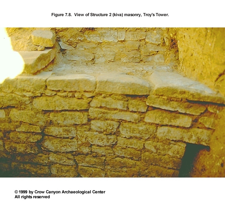
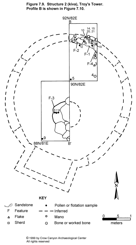
Structure 2 is a masonry-lined pit structure found in randomly selected sampling unit 90N/82E and judgmentally selected test pits 91N/82E and 88N/81E (a 1-×-2-m pit in Sampling Stratum 4). Excavation exposed the north wall, including a portion of the bench, a collapsed pilaster, a niche, and a strip of the main chamber floor in which a segment of the hearth was found (Figure 7.8 and Figure 7.9). The floor of Structure 2 lies 2.05 m below the modern ground surface. The diameter of the main chamber is approximately 4 m.
Construction
Walls. The masonry lining of Structure 2 consists entirely of horizontally coursed stone. The lower lining wall is 13 to 21 cm thick and 86 cm high (from the floor to the bench surface). The upper lining wall above the bench surface had partly collapsed, but the portion that remains is 8 to 11 cm thick and 54 cm high. Both walls are a single stone wide, with semi- to fully coursed masonry that covers sterile sediments.
The walls were constructed of minimally shaped, tabular to blocky sandstone (some grinding and flaking were observed on the edges of the stones). The mortar is a red brown silty clay loam similar in color and texture to the sterile B-horizon sediments; the joints are between 1 and 2 cm wide. An abundance of B-horizon sediments would have been produced during the aboriginal excavation of Structure 2, and this may have been the source for the mortar. A trace of plaster was observed on the walls, but preservation was poor. Three features--a bench, a pilaster, and a niche--were associated with the Structure 2 walls.
Feature 1 (Bench 4): A portion of Bench 4 was uncovered during excavation. Unburned roof fall covered the bench surface, which consisted of adobe laid on top of sterile sediments. Several artifacts lay on the surface, including the following: seven flakes (PLs 13, 14, 15, 16, 17, 20, and 21), a Mesa Verde Black-on-white dipper sherd (PL 18), and a complete two-hand mano (PL 19). The dipper sherd was heavily worn from use. This sherd is a part of the same vessel as a sherd found in the tunnel that is interpreted as connecting the kiva and the tower. The tunnel is described below as Feature 4 under the Remaining Sampling Stratum 2 Units heading. In addition, a pollen sample, PL 10, and a flotation sample, PL 11, were collected from the bench surface.
Feature 2 (Pilaster 4): Part of a collapsed pilaster defines an edge of the bench segment, Feature 1. A maximum of two courses of masonry remain intact. It appears that the pilaster was constructed first, then the upper lining wall and the adobe surface of the bench were constructed to abut the pilaster. The pilaster corner stone that remained in place had been heavily shaped by pecking. Five similarly shaped stones that lay in the main chamber fill near the pilaster are probably stones that fell from this pilaster. Therefore, it is clear that the pilaster stones were not salvaged when Structure 2 was abandoned. The stones lay in a stratum of fill interpreted as unburned roof fall. It may be that the salvaging of roof timbers during abandonment caused the collapse of the pilasters.
Feature 4 (Niche): Excavation exposed a portion of a niche in the lower lining wall along the east profile of grid unit 91N/82E. Dimensions are incomplete due to the limited portion of the feature exposed. The base of the niche is 36 cm above the floor and the niche is 22 cm high.
Floor. The floor of Structure 2 consists of a prepared adobe surface constructed on top of a sterile caliche (Cca) horizon. Artifacts on the floor include an animal bone (PL 1), two pieces of chipped-stone debris (PLs 2 and 3), and a fragment of a ground, polished, and striated bird bone awl (PL 4). The worked bone was found in the screen. Its location on the map has been approximated on the basis of where the excavator was known to be working when the bone was found. Excavation also exposed the west half of the Structure 2 hearth.
Two pollen samples were collected beneath rocks lying directly on the floor, and an upper control sample was collected to aid in the interpretation of these samples (see Chapter 17). Economic pollen recovered from these samples includes beeweed, purslane, and corn; cheno-am pollen counts may be high enough that their presence, too, can be interpreted as anthropogenic.
Feature 3 (Hearth): A dense concentration of sandstone slabs covered the hearth. Several slabs were in direct contact with the Structure 2 floor and the upper stratum of hearth fill. The slabs must have been deposited shortly after abandonment of the kiva; they may have been placed over the hearth before the collapse of the unburned roof, or they may have been a part of the roof that fell onto the hearth when the roof collapsed. Several slabs were worked loose so that we were able to excavate the western third of the hearth.
The hearth had been excavated into the native sediments (caliche), then lined with adobe. Two strata fill the hearth: the upper stratum, 10 to 12 cm thick, is a red brown silty clay loam interpreted as unburned roof fall; the lower stratum consists of a layer of ash, 8 to 10 cm thick, that fills the remainder of the pit. An archaeomagnetic dating sample collected from the hearth rim produced a date of A.D. 1225-1325 as the most likely date. The hearth exhibited no evidence of remodeling.
Two flotation samples were analyzed from the hearth, but produced little in the way of botanical remains (see Chapter 16). Pine and juniper were the only plant remains recovered. These are interpreted as fuel.
Roof. Pilasters supported the Structure 2 roof. Roof-support systems in kivas in the Mesa Verde region typically consist of six pilasters, and this may be the case in Structure 2. Fill above the floor appears to be unburned roof fall, but no timbers were found in that stratum, which suggests that they may have been salvaged for use elsewhere when Structure 2 was abandoned. Arguments for this interpretation are presented in greater detail in the section below on stratigraphy.
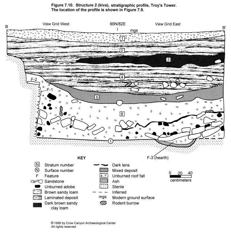
Stratigraphy
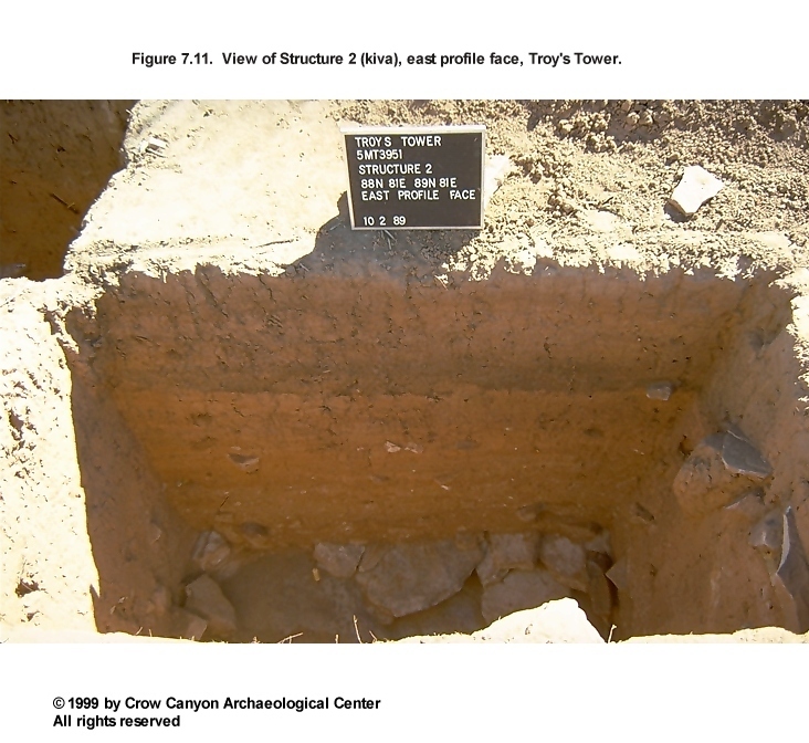
Figure 7.10 illustrates the Structure 2 stratigraphic profile. Figure 7.11 shows a view of the east profile face. Stratum 6 covers the Structure 2 floor. It is a massive deposit of red brown sandy clay loam, .66 to 1.0 m thick. Inclusions are abundant, and their presence distinguishes Stratum 6 from the other strata in the profile. The Stratum 6 inclusions consist of calcium carbonate aggregates, unburned adobe with vegetal impressions, abundant sandstone (including pilaster stones), and a thin, dark gray lens, the origin of which is unclear.
Stratum 6 shows no evidence of laminations or any sorting by particle size that would have resulted from wind or water deposition. Instead, the sediments of Stratum 6 appear to have been deposited as dry aggregates of material. The color and texture of this stratum resemble B-horizon sediments. The calcium carbonate inclusions range in size from flecks to 3 cm in diameter, and they do not resemble calcium carbonate that accumulates naturally (natural calcium carbonate accumulation appears as mycelial streaks on ped faces in the Bca and Cca horizons). The fact that the calcium carbonates occur as aggregates, in conjunction with the similarity in color and texture to native B-horizon sediments, suggests that Stratum 6 consists of redeposited B- to C-horizon sediments. One plausible explanation is that B-horizon sediments removed during the excavation of the pit for Structure 2 were subsequently reused as roof-construction material in that same structure. Pieces of adobe with well-formed vegetal impressions indicate that some sediment was applied when it was moist and plastic. The moist sediment may have been placed directly on top of the vegetal material used in the roof construction in an effort to better seal the roof. Dry sediment may have been used to complete the roof construction.
The presence of unburned adobe with vegetal impressions in Stratum 6 not only supports the interpretation that Stratum 6 consists of unburned roof fall, but also offers clues as to when and how Stratum 6 deposition occurred. The presence of vegetal impressions in the adobe indicates that the adobe was not subjected to a great deal of erosion. This in turn suggests that the material was not transported a great distance and was both deposited and covered quickly. The same is true for the calcium carbonate aggregates; these would disintegrate if transported over a great distance and would dissolve in solution if carried by water.
The sandstone in Stratum 6 also appears to be structural collapse. Several stones were clearly pilaster corner stones. The sandstone inclusions in Stratum 6 were oriented at a variety of angles--another sign of rapid, cultural deposition. The concentration of sandstone slabs covering the hearth may have been the stones that lined the Structure 2 roof-entry hole.
A thin gray lens was also present within Stratum 6, and much of the unburned adobe lay near this lens. The lens was not continuous over the entire excavation unit but, rather, occurred in patches. The origin of this material is uncertain, but it may be organic material associated with the roof or soot blackening on the inside of the roof.
Stratum 6 is therefore interpreted as unburned roof fall deposited when Structure 2 was abandoned. The absence of naturally deposited sediment between Stratum 6 and the floor supports the interpretation that there was little time between the abandonment of the structure and the collapse of the roof. Roof collapse at abandonment probably resulted from cultural activity and not a natural catastrophic event. There was no trace of the hundreds of roof timbers that would have been a part of a cribbed roof. If these timbers had been deposited along with the remainder of the unburned roof fall, some indication of their presence would remain (for example, high organic content, displacement structures, partly decomposed beams). The absence of timbers suggests that they were salvaged for use elsewhere. Salvaging the timbers would result in the deposition of the unburned roof fall sediments on the floor of the structure.
Several tools were found in the roof fall stratum. These include a bone awl fragment, a modified flake, and a Pueblo III-style, side-notched projectile point.
Stratum 5 is 20 cm thick, and it resembles Stratum 6 in color, texture, and inclusions, but the inclusions in Stratum 5 are smaller and fewer. In a sense, Stratum 5 is a transition between the relatively clean Stratum 4 fill and Stratum 6, which is so heavily mottled with inclusions. Stratum 4 is a sandy clay loam that had the brightest red brown color of any stratum in the profile. Charcoal flecks, calcium carbonate flecks, and small sandstone rocks are present but in small quantities. Faint laminae, sorted by particle size, are present; this is evidence that the sediments of Stratum 4 were deposited by water.
Stratum 3 is 10 to 24 cm thick, and its dark brown color makes it easy to distinguish it from the other strata in the Structure 2 profile. The dark color may have resulted from the decomposition of unburned organic material or charcoal. A few small burned adobe pieces are present in Stratum 3, as are tiny flecks of charcoal. Similar dark strata were documented above Structure 3 and near the top of Feature 3 in sampling unit 90N/88E. Some sort of cultural or natural burn may have occurred after Troy's Tower was abandoned, producing this dark stratum. A pile of stones, Feature 5, lay at the base of Stratum 3 in the southwest corner of excavation unit 88N/81E.
Stratum 2 is a 29-cm-thick laminated deposit that covers Stratum 3 and Feature 5. The only inclusions were occasional charcoal flecks and sandstone pebbles. Stratum 2 is a postabandonment water-deposited stratum. Stratum 1 is a layer of brown sandy loam, 20 cm thick, distinguished from Stratum 2 by a darker color and the absence of laminations. Stratum 1 is the modern A horizon that covers the entire site.
Feature 5 (Rock Concentration). Feature 5 is a mound of sandstone slabs that was partly exposed in the excavation unit. The exposed portion of Feature 5 measured 90 cm long, 75 cm wide, and 28 cm high. Because the stones lay in a pile, their deposition is assumed to have been cultural. It appears that the stones were deposited on top of Stratum 4, where Stratum 3 sediments then accumulated around them. Feature 5 contained no artifacts, and its function is unknown.
Dating
The only absolute dates for Troy's Tower are from an archaeomagnetic sample collected from the hearth in Structure 2. This sample produced two date ranges: A.D. 1015-1025 and A.D. 1225-1325. The latter date range is most likely, given the presence of Mesa Verde Black-on-white pottery in Structure 2. The fact that the roof timbers had been salvaged from Structure 2 indicates that this structure was abandoned before the abandonment of the Mesa Verde region. Because the entire region was abandoned by A.D. 1300, the archaeomagnetic date range can be further narrowed down to A.D. 1225-1290/1300.
Structure 2 Interpretations
Structure 2 is a masonry-lined pit structure, or kiva. A tunnel links Structure 2 to the tower, Structure 1. Artifacts found on the bench of the kiva are interpreted to be de facto refuse. Additional excavation might clarify how Structure 2 was used. Flotation analysis of the ash produced only charcoal interpreted as fuel, so it is not clear if this feature was used for cooking during the last use of Structure 2. Archaeomagnetic dates from the Structure 2 hearth indicate that Structure 2 was in use between A.D. 1225 and 1290/1300.
The roof timbers were salvaged from Structure 2 at abandonment. The rest of the unburned roof collapsed into the structure, sealing the floor. Sometime after Structure 2 was abandoned and had started filling by natural processes, a concentration of stones was placed in the fill. These stones were surrounded by dark fill that may have been the result of a fire at the site. The rock concentration is far enough below the modern ground surface that it is believed to be a Puebloan feature rather than a historic feature. Therefore Structure 2 was abandoned and filled before the abandonment of the surrounding region at approximately A.D. 1300.
Structure 3
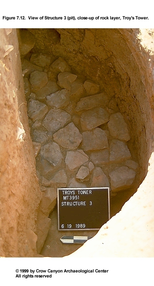
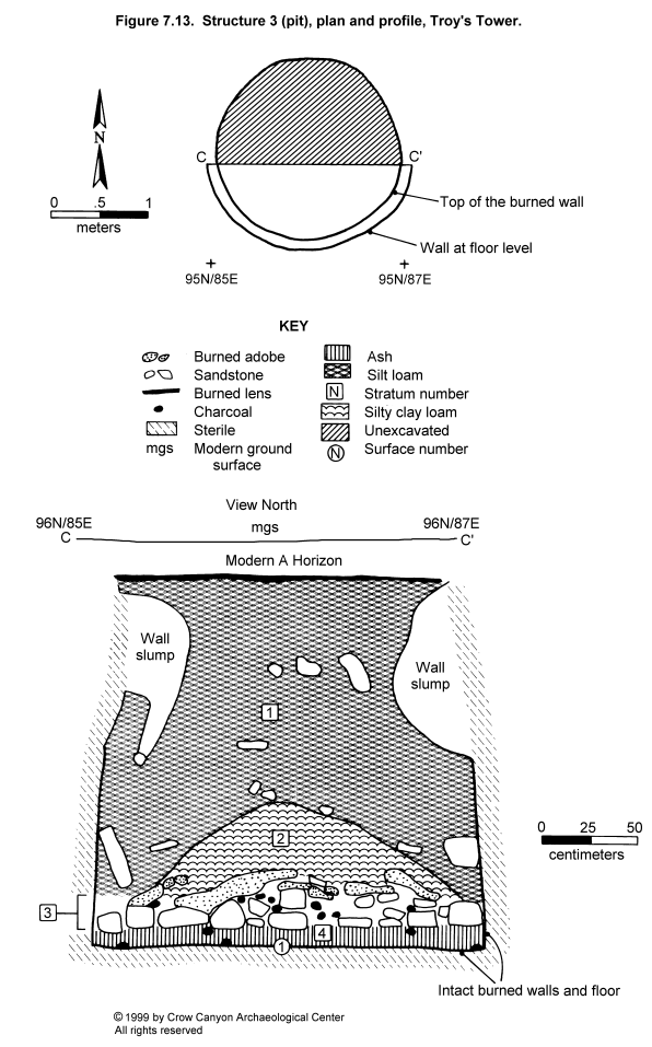
Structure 3 is a large, bell-shaped pit first discovered during the 1988 field season in sampling unit 95N/85E. At that time, it was provenienced as Feature 1 of Sampling Stratum 2. Expanded excavations during the 1989 field season included an adjacent randomly selected unit, 95N/86E, also in Sampling Stratum 2, and four contiguous judgmentally located 1-×-1-m excavation units in Sampling Stratum 4 (95N/87E, 96N/87E, 96N/86E, and 96N/85E). Opening up these additional units allowed us to define the horizontal boundaries of Structure 3, but only the south half of the structure was excavated (Figure 7.12 and Figure 7.13). Structure 3 has a diameter of 2.06 m at the base, which is 2.12 m below the modern ground surface. Charcoal, ash, and a layer of sandstone slabs, primary refuse associated with the last use of Structure 3, cover the floor.
Construction
Walls. The extent of the Structure 3 fill could be defined at the contact with the sterile B horizon, 34 cm below the modern ground surface. The fill outline is amorphous at the level of detection because the upper walls had slumped into the pit. Intact walls exist 1.30 m below the modern ground surface; at this level, the pit is 1.94 m in diameter. The walls of Structure 3 consist of oxidized native sediments; the oxidation was the result of the use of the structure as a roasting pit. Digging-stick impressions are still visible in the sides of the pit.
Floor. The floor of Structure 3 consists of use-compacted native sediment, which, like the walls, had been heavily burned. The boundary with the fill above the surface was abrupt and smooth, and the floor sloped up toward the walls.
Stratigraphy
Primary refuse covers the floor of Structure 3. Primary refuse includes both Strata 3 and 4. Stratum 4 is an 8- to 12-cm-thick layer of charcoal, ash, and some burned adobe (Figure 7.13). The charcoal was relatively small, the largest piece being 6 cm in diameter. A layer of sandstone slabs caps Stratum 4. The sandstone layer was burned, indicating that it had been set into the structure as a part of its use. However, it was not set in adobe mortar. Stratum 3, another stratum of charcoal, ash, and adobe covers Stratum 4 and the sandstone slabs. At the top of Stratum 3 is a nearly continuous layer of adobe across the exposed portion of the structure. The adobe may be the remains of the Structure 3 walls that collapsed into the fill, or it may be a layer of sediment placed over the charcoal during a burning episode.
Both Stratum 3 and 4 are interpreted as primary refuse associated with the last use of Structure 3. Pieces of charcoal collected for tree-ring dating samples were all identified as either juniper or pinyon pine. In addition to the charcoal, juniper bark was observed, primarily in Stratum 3. Analysis has been completed of flotation samples collected from both Stratum 3 and Stratum 4 (see Chapter 16). Juniper and bitterbrush/cliffrose-type charcoal were found in both strata. Serviceberry/squawapple-type wood was found only in Stratum 3, and sagebrush leaf and flower buds were present only in Stratum 4. Corncobs were present in the lower stratum and could be the remains of fuel or roasted food. Stratum 4 also produced many seeds, including cheno-am, purslane, prickly pear, groundcherry, and Capparaceae seeds. Cyperaceae achenes and Gramineae caryopses were found in Stratum 4 as well. The seeds may represent food prepared in this feature or plants added to the roasting pit to produce steam. Artifacts in the primary refuse of Strata 3 and 4 were relatively scarce. Fourteen sherds were recovered, including Pueblo III White Painted pottery, along with several pieces of chipped-stone debris.
Stratum 2 is a brown to yellowish red silty clay loam that contains almost no inclusions except for mycelial accumulation of calcium carbonates on the ped faces. Stratum 2 lies in a mound in the center of Structure 3. The processes responsible for the deposition of Stratum 2 are unclear. Stratum 2 could be slumped upper wall sediments or a collapsed roof or covering of some sort. Mesa Verde Black-on-white pottery was present in Stratum 2.
Stratum 1 fills the remainder of Structure 3. It is less red and coarser grained than Stratum 2 and contains numerous charcoal (flecks), calcium carbonate (flecks), and sandstone inclusions. Some of the pieces of sandstone are pecked building blocks with curved faces, similar to stones typically used in tower construction. Possibly, Structure 1 was collapsing at the same time that Structure 3 was filling. Overlying Structure 3 was a thin, dark lens, apparently the remains of decomposed charcoal. The upper fill of Structure 2 and the fill covering Feature 3 in Sampling Stratum 2 contained a similar dark stratum, which may be evidence for a postabandonment fire at Troy's Tower.
Dating
Seventy-three tree-ring samples were collected from above the sandstone slabs, and 49 were collected from the fill beneath the slabs. Twenty-nine samples produced dates (Table 7.1).
The final use of Structure 3 took place sometime after A.D. 1271. An archaeomagnetic date collected from the floor produced a date of A.D. 1175 to 1400. The presence of Mesa Verde Black-on-white pottery in the fill of Structure 3 indicates that the structure was probably used after A.D. 1180 and abandoned before A.D. 1300. Use and abandonment of Structure 3 after A.D. 1271 makes it one of the latest dated facilities in the Sand Canyon locality and clearly demonstrates its contemporaneity with the occupation at Sand Canyon Pueblo.
Structure 3 Interpretations
Structure 3 is a deep, bell-shaped pit that burned before abandonment. Strata above the floor include two layers of charcoal and ash separated by a layer of sandstone slabs. Botanical remains recovered from the ash and charcoal strata suggest that Structure 3 was used as a roasting pit. The last roasting event took place sometime after A.D. 1271. Postabandonment stratigraphy indicates that other areas of the site were also abandoned at the same time that Structure 3 was filling. A burned lens that covers the fill of Structure 3 suggests that limited use of the site may have occurred after these structures were abandoned or that there was a natural fire that burned Troy's Tower after the site and the region were abandoned.
It is not known if Structure 3 functioned only as a roasting pit. There was no trace of refuse from the repeated use and cleaning out of Structure 3 in the Sampling Stratum 2 excavation units surrounding Structure 3. Troy's Tower has no known surface rooms and no known storage facilities. It is possible that Structure 3 originally functioned as a storage facility and that its use as a roasting pit was only its last use.
Remaining Sampling Stratum 2 Units
Sampling Units 86N/85E and 87N/85E
These two sampling units are located between the tower, Structure 1, and the kiva, Structure 2. Sampling unit 86N/85E was a randomly selected sampling unit, and 87N/85E was a judgmentally located sampling unit that was excavated to expose the north side of a feature encountered in 86N/85E.
The upper fill in both sampling units was wall fall from the tower. The wall fall continued down to the contact with sterile sediments, approximately 30 cm below the modern ground surface. At this level, the outline of a pit feature, Feature 4 in Sampling Stratum 2, was visible. This pit feature is interpreted as a tunnel that connects the tower and the kiva.
Feature 4 (Tunnel). A portion of this pit feature was found in sampling units 86N/85E and 87N/85E (Figure 7.7). The north and south boundaries of the feature were found, but the feature extends out of the sampling units to the east and west, toward the tower and kiva.
The feature was excavated in two strata and a surface level. However, when the profile was drawn later, three strata were recognized above the floor of the tunnel. The upper stratum of fill contained sandstone rubble and was 30 cm thick. The sandstone rubble lay in a matrix of brown sandy loam with flecks of charcoal and calcium carbonate. The sandstone rubble could be either wall fall from the tower or stone used to construct the tunnel roof. Below the upper stratum is a mottled, gray brown fill that contains burned adobe nodules and more charcoal and calcium carbonate flecks. This lower fill is 30 cm thick along the east edge of the feature and 20 cm thick along the west edge. Just above the base of the feature is a stratum containing ash, burned adobe, large pieces of charcoal, and calcium carbonate. This lowermost stratum was a maximum of 16 cm thick at the west end of the tunnel and 5 cm thick at the east end. The two lower strata were combined during excavation down to a level 5 cm above the tunnel floor. The last 5 cm was excavated as a surface level.
The ash and burned adobe found in the fill just above the tunnel floor is interpreted as material from the tower floor (our excavations in Structure 1 had documented the primary refuse from a possible hearth covering the floor). The floor of the tunnel consists of sterile sediment, which shows no sign of burning. The tunnel floor slopes down 36 cm from the east end to the west end.
At the west end of the tunnel, the feature fill is capped by sterile sediments; it looks like a tunnel in profile. At the east end, the tunnel fill is not capped by sterile, and the top of the feature is near what must have been the prehistoric ground surface. Thus, it appears that the tunnel must have been roofed from the east end of our sampling units to the point where it terminates, presumably the tower. If the excavated portion of the tunnel continues in the same direction toward the tower, it would intersect the tower at a place where the tower wall has collapsed and there is only a minimum of standing wall remaining. This section of tower wall may have collapsed because the tunnel ran beneath it. It is difficult to know how the tunnel intersects the kiva, Structure 2. If the alignment of the tunnel is projected to the west, the tunnel would intersect with the kiva at the location of the southeast bench. Depending on the orientation of the kiva, however, it is also possible that the tunnel intersects the kiva at the southern recess.
Artifacts recovered from the fill of the tunnel include 17 sherds, one piece of chipped-stone debris, and burned corncobs and kernels. One of the sherds is a Mesa Verde Black-on-white dipper sherd that is from the same vessel as the Mesa Verde Black-on-white sherd found on the bench of the kiva. If the lower fill is material that has eroded into the tunnel from the tower floor, then portions of this vessel would have been in both the tower and the kiva at the time the structures were abandoned.
Sampling Unit 90N/88E
This is a sampling unit located north of the tower, Structure 1. Fill in 90N/88E consists of two strata, removed down to the sterile B horizon. Stratum 1 was a brown loam, approximately 20 cm thick. Stratum 1 contained wall fall from the tower in the south half of the sampling unit and is interpreted as a postabandonment, natural deposit.
Stratum 2 was darker than Stratum 1. The dark color appeared to be the result of ash and burned sediments present in Stratum 2. This dark stratum may be from the same source as the dark lens that covers Structure 3 fill and Stratum 3 in Structure 2. Wall fall was present in the entire sampling unit in Stratum 2. Like Stratum 1, Stratum 2 is believed to be predominantly a natural, postabandonment deposit. Sterile sediments were found in the southeast corner of 90N/88E at the base of Stratum 2, and fill continued down in a large pit feature, Feature 3, in the remainder of the sampling unit. The stratigraphic boundary between Stratum 2 and the sterile sediments is interpreted as the approximate location of the prehistoric ground surface because wall fall lay on this surface.
Feature 3 (Pit). Feature 3 is a large, amorphous pit. The exposed portion measures 1.00 cm long, .95 cm wide, and .50 m deep. This portion of the pit has a roughly circular plan and is basin-shaped in profile. The walls are wavy and undulating. Wall fall fills the feature, although it is more dense in the upper half of the pit. Wall fall lay in a brown silt loam with calcium carbonate and charcoal flecks. Faint laminae near the top of the feature fill are evidence for natural deposition. A burned lens is present 20 cm below the top of the feature. This burned lens may be further evidence of a fire at the site after it was abandoned.
Artifact density in the feature fill was relatively high. Forty-one sherds (including Pueblo III White Painted), one peckingstone, a small amount of raw clay, a mineral sample (which leaves a yellow streak and might be pigment), and 52 pieces of chipped-stone debris were recovered from the feature fill. The density of artifacts suggests that some cultural refuse might be mixed in with the naturally deposited sediment and wall fall.
The undulating walls and base of the pit argue against interpreting Feature 3 as a structure. It may have been a borrow pit from which construction sediments were collected. The presence of wall fall throughout the fill suggests that Feature 3 was open when the site was abandoned. The feature appears to have filled by natural processes after the site was abandoned.
Sampling Unit 90N/90E
This sampling unit is also located north of Structure 1. A single stratum of red brown, silty clay loam, 28 cm thick, was removed down to the contact with sterile sediments. A pit, Feature 2, was found at this level.
Feature 2 (Pit). This is an oval, basin-shaped pit that measures 48 cm long, 34 cm wide, and 7 cm deep. Feature 2 fill consisted of a red brown silty clay loam with inclusions of small sandstone and charcoal flecks. No artifacts were recovered from the feature fill. The function of this pit is not known.
Sampling Units 97N/81E and 91N/91E
The remaining randomly selected Sampling Stratum 2 units were excavated in a single stratum down to the contact with the sterile B horizon. Stratum 1 in both sampling units was a red brown silt loam between 15 and 23 cm deep. These two sampling units contained no features.
Sampling Units 94N/82E, 94N/83E, 95N/82E, and 95N/83E
These are four contiguous, judgmentally located 1-×-1-m excavation units (Figure 7.4). Located on the edge of a low mound between Structures 2 and 3, these units were excavated because we were looking for nonmasonry (jacal or post-and-adobe) rooms. Sediments were removed down to the contact with the sterile B horizon; this contact was found between 24 and 28 cm below the modern ground surface. The stratigraphic contact was sprayed with water and troweled several times to look for features, but no features and no evidence of structures were found.
Midden (Sampling Stratum 3)
Sampling Stratum 3 is the midden sampling stratum, located south of Structure 1 (Figure 7.3 and Figure 7.4). A dense artifact scatter and gray brown sediments were the surface remains used to draw boundaries around this sampling stratum, provenienced as Nonstructure 1. Sampling Stratum 3 contains 59 sampling units, five of which were randomly selected for excavation (83N/86E, 82N/89E, 80N/87E, 79N/92E, and 79N/87E). Excavation also took place in one judgmentally located test pit (81N/89E). This test pit, located in center of the midden, was excavated to increase the sample size.
Each of the Sampling Stratum 3 units had a single stratum of cultural fill. Depth of the excavation units ranged from 22 to 39 cm. Stratum 1 fill was a brown to red brown silt loam. Artifacts and small pieces of sandstone were common in Stratum 1, especially in the upper 20 cm. The edge of Structure 4 was found in 79N/87E; most of this pit lies outside of Sampling Stratum 3. Structure 4, the only feature in Sampling Stratum 3, will be described after a brief discussion of the midden artifacts.
Midden Artifacts
Excavations in the midden encountered the highest artifact density on the site: 983 sherds (43.8 percent of the site total), 8 tools (18.2 percent of the site total), and 195 pieces of chipped-stone debris (19.8 percent of the site total) were recovered. The volume of fill excavated in this sampling stratum was much less than that excavated in the other sampling strata (where more sampling units were excavated and/or deep structure fills were encountered).
Pottery from the midden includes the following decorated white ware types: Late White Painted with mineral paint (N = 1), Late White Painted with carbon paint (N = 84), Late White Unpainted (N = 286), Pueblo III White Painted (N = 37), McElmo Black-on-white (N = 3), and Mesa Verde Black-on-white (N = 8). Gray ware types include Indeterminate Plain Gray (N = 3) and Indeterminate Local Corrugated Gray (N = 554). The assemblage is dominated by Pueblo III types, with only a few earlier sherds present. The refuse from this midden is therefore associated with the late Pueblo III use of the site. Among the complete and fragmentary tools found in the midden were four manos (including two complete two-hand manos), two hammerstones, one peckingstone, one fragmentary projectile point, and three modified sherds.
A single flotation sample was analyzed from the midden. Juniper and pine charcoal were found, along with a pinyon pine needle fragment and an unknown seed fragment (see Chapter 16). These remains are interpreted primarily as fuel.
Midden Interpretations
The Troy's Tower midden is similar to the middens on the mesa-top unit pueblo sites in that it is located south of the main architectural features. Like the unit pueblo middens, it was defined by the densest concentration of artifacts on the site and is therefore interpreted as the main location for the deposition of secondary refuse. Unlike the unit pueblo middens, however, the Troy's Tower midden is relatively small and shallow. The size of the midden is evidence that Troy's Tower was not used as intensively as the unit pueblos. Troy's Tower may have been occupied on a short-term basis rather than occupied year round. Alternatively, Troy's Tower may have had a specialized function, different from that of the unit pueblos, which served as generalized habitation sites. This is discussed further in the final chapter of this report.
Structure 4
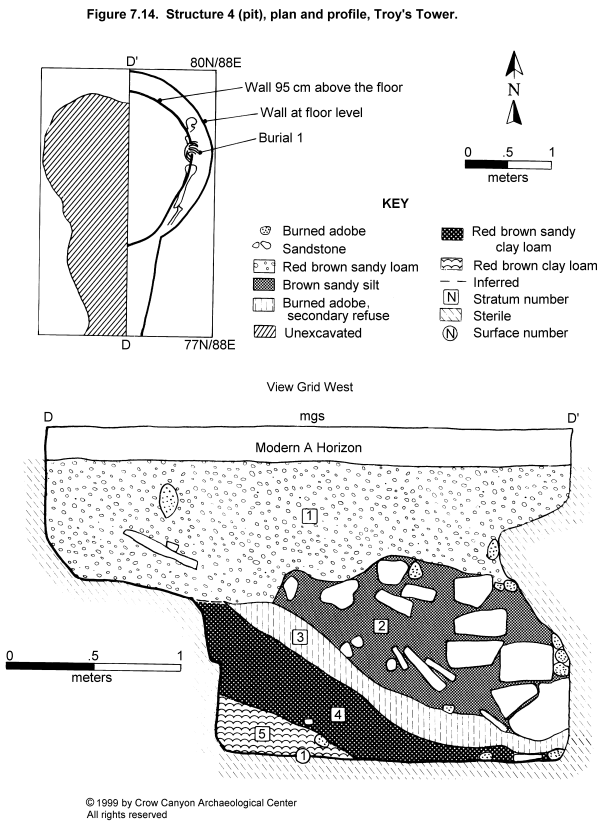
Excavation of Structure 4 began during the 1988 field season. A corner of a pit was located and provenienced as Feature 1 of Sampling Stratum 3. Expanded excavations in 1989 defined the outline of this pit, which extended into Sampling Stratum 4. Due to the size of the pit, the provenience was changed to Structure 4.
Excavation of five contiguous, judgmentally located test pits (77N/86E, 77N/87E, 78N/86E, 78N/87E, and 79N/86E--all in Sampling Stratum 4) exposed the majority of the Structure 4 outline (Figure 7.14). The east half of Structure 4 was subsequently excavated, revealing it to be a large, partly bell shaped pit. The deepest part of the pit, in the north end, measures 1.99 m in diameter at its base and is 1.86 m below the modern ground surface. The pit is much shallower at the south end; this portion is 90 cm long and 86 cm deep. It is not clear if the shallower portion is the remains of an earlier pit that was truncated by Structure 4 or if it is a part of Structure 4 (for example, an entry into the structure).
Construction
Walls. The construction of Structure 4 involved excavating a pit into sterile sediments. These sterile sediments (the Bt, Bca, and Cca horizons) became the Structure 4 walls. On the north side of the structure, the walls are distinctly bell shaped; on the south side of the structure, the walls are vertical. The floor was constructed by covering the caliche horizon (the Cca horizon) with a red brown silty clay loam adobe.
Stratigraphy
Structure 4 began to fill naturally after abandonment (Figure 7.14). Strata 4 and 5 are both naturally deposited strata distinguished from each other by changes in the texture and the density of the inclusions. Stratum 5 is a red brown clay loam mottled with bits of calcium carbonate and flecks of charcoal. Stratum 4 is sandier and contains more calcium carbonate and charcoal inclusions than Stratum 5.
Stratum 3 is a culturally deposited stratum that contains chunks of burned adobe. Structure 4 shows no sign of burning, so the adobe is believed to be secondary refuse. Shortly after the deposition of Stratum 3, a human body was placed in Structure 4 (this burial is described below). The body lay in Stratum 2, a brown sandy silt with large sandstone inclusions and some burned adobe. The sandstone covered the remains and was part of the interment. Some of the sandstone pieces were pecked-block building stones with curved surfaces typical of material used in tower construction; therefore the interment is inferred to have taken place when Structure 1 was collapsing. The top of Stratum 2 contained burned adobe, identical to the material found in Stratum 3. It is possible that Stratum 3 was partly removed when the body was placed in Structure 4, then used as backfill to complete the interment.
Stratum 1 filled the remainder of Structure 4. It is similar to Strata 4 and 5, only coarser in texture. Stratum 1 consists of a red brown sandy loam with caliche and charcoal flecks; it appears to be a natural, postabandonment deposit. The fact that Stratum 1 lay entirely over Structure 4 suggests that the south end of the structure, where the pit was shallow, filled at the same time as the deeper portion of the pit.
Burial 1
A burial lay near the base of Stratum 2 next to the east wall of Structure 4, 65 cm above the floor (Figure 7.14). The individual, an adult, lay in an extended position, on its left side, facing the east wall. The skull faced down with the head to the north. Several bones were missing, including the right arm, right leg, right patella, right hand, and right foot. The left foot is present but not articulated. Scattered in the fill near the burial were small bones that may be part of the left foot. Rodent activity in the sediments surrounding the burial may explain the missing small bones. Larger bones may have been removed by carnivores. The stones placed around the body, however, would have made it difficult to disturb the burial, and it is possible that the arm and leg were missing before the individual was interred.
The individual is identified as a female, 25 to 30 years old (see Chapter 19). A large depression fracture is present above the right orbit. This fracture may have been caused by a blow to the head and may have been the cause of death. Carbon isotope analysis of this individual indicates that her diet was more similar to the diets of individuals from Sand Canyon Pueblo than to the diets of individuals from the other tested sites.
Structure 4 Summary and Interpretations
Structure 4 is a large pit of unknown function. It could have been a storage pit or a large, subterranean mealing room (such rooms are sometimes found on Pueblo III sites). Structure 4, however, did not have any floor features or floor artifacts to aid in the interpretation of its function.
When Structure 4 was abandoned, it began to fill naturally. Shortly after it was abandoned, a burial was placed in the fill. The burial was covered with stones that are believed to be from the collapsed tower wall, which indicates that the tower was also abandoned when the body was interred.
Outer Periphery (Sampling Stratum 4)
Sampling Stratum 4 is the outer periphery sampling stratum surrounding the other sampling strata. A light artifact scatter on the surface was used to define the boundaries. Sampling Stratum 4 consists of 534 sampling units, six of which were excavated (97N/89E, 91N/96E, 87N/99E, 85N/99E, 84N/79E, and 72N/93E). Several judgmentally located test pits were excavated in Sampling Stratum 4 as well, in order to expand the excavation around Structures 2, 3, and 4. These judgmental squares have been discussed as part of the individual structure descriptions and will not be discussed further.
Excavation involved the removal of a single stratum of fill in each of the Sampling Stratum 4 sampling units. Stratum 1 is a red brown silt loam that ranged between 17 and 21 cm deep. Artifacts were scarce in these sampling units, except for 72N/93E. This sampling unit contained many artifacts, especially in the upper 10 cm. The high artifact density is attributable to the location of the sampling unit adjacent to the old bulldozer road leading to a carbon dioxide well (Figure 7.2). Road construction appears to have displaced artifacts from the midden and scattered them along the edge of the road cut. A single feature was uncovered in Sampling Stratum 4, in unit 87N/99E.
Artifacts from the outer periphery include 631 sherds and 294 pieces of chipped-stone debris. Fifteen stone tools were recovered including one metate, three manos, two peckingstones, two cores, one polishing stone, five modified flakes, and one other modified stone.
Feature 1 (Pit)
A portion of a pit feature was uncovered in 87N/99E. The portion of the pit in the sampling unit measures 1.00 m long, 0.57 m wide, and 0.14 m deep. A dark, brown to black organic silt filled the feature. This fill contained a modified flake and some small pieces of burned sandstone. There was no burning on the walls of the pit, and the fill appears to represent material deposited in the pit as secondary refuse.
Troy's Tower Artifacts
The pottery, stone tools, and chipped-stone debris from Troy's Tower are summarized in tables at the end of this chapter (Table 7.2, Table 7.3, Table 7.4, Table 7.5, and Table 7.6).
There were 2,242 sherds recovered from Troy's Tower; this pottery is predominantly Pueblo III pottery. The only earlier material is Indeterminate Plain Gray (N = 11), Mancos Corrugated (N = 3), Mummy Lake Gray (N = 1), Pueblo II White Painted (N = 1), Mancos Black-on-white (N = 5), and Late White Painted with mineral paint (N = 6). Pueblo III pottery includes Mesa Verde Corrugated (N = 1), Late White Painted with carbon paint (N = 201), Pueblo III White Painted (N = 73), McElmo Black-on-white (N = 6), and Mesa Verde Black-on-white (N = 25). Indeterminate Local Corrugated Gray, which could be either Pueblo II or Pueblo III, makes up the majority of the pottery assemblage, with 1,207 sherds (53.8 percent of the total assemblage). The predominance of Pueblo III decorated white ware types suggests that the corrugated sherds, as well as the majority of the refuse deposited on the site, date to the late Pueblo III period.
Complete and fragmentary tools recovered from the site include one metate, 11 manos, two hammerstones, four peckingstones, four projectile points, two bifaces, one drill, five cores, one polishing stone, nine modified flakes, a bone awl fragment, two pieces of modified bone, and nine modified sherds. Although the number of sampling units excavated at Troy's Tower is similar to the number excavated at some of the other tested sites, the Troy's Tower collections are much smaller than the assemblages from the mesa-top unit pueblos. Despite the smaller artifact totals at Troy's Tower, certain tool types are at least as common as they are at the mesa-top unit pueblos that date to the A.D. 1200s. For example, there are more manos and mano fragments in the collections from Troy's Tower than there are from Roy's, Lillian's, and Shorlene's. The number of projectile points is similar when Troy's Tower and the unit pueblos are compared.
Also present are gizzard stones, eggshell, a stone pendant fragment, a stone bead, a shell bead fragment, and several mineral samples that may be pigment. Finally, 984 pieces of chipped-stone debris were recovered from the site.
Nonlocal material is relatively rare. Only 15 pieces of chipped-stone debris were from nonlocal sources. Pottery made outside of the locality includes Bluff Black-on-red (N = 1) and a piece of painted San Juan Red Ware too small to identify to traditional type.
Troy's Tower Summary and Interpretations
Troy's Tower is a small site that rests on a mesa top overlooking Sand Canyon. The absence of a masonry roomblock at Troy's Tower distinguishes it from the other tested sites. Troy's Tower is most similar to Mad Dog Tower (5MT181), which has a tower, a kiva, and a single masonry room. The site was tested with 22 randomly located sampling units and 18 judgmentally located sampling units.
A collapsed masonry tower, Structure 1, is located in the center of the site. No other masonry architectural units were obvious on the surface, but the presence of burned adobe on the surface suggested that nonmasonry rooms might be present. Testing, however, revealed no evidence of nonmasonry surface rooms. Testing in a shallow surface depression resulted in the discovery of Structure 2, a masonry-lined pit structure. Also found was a portion of a tunnel that connects the tower and the pit structure. A small midden is present south of the tower and pit structure.
Testing in Structure 1 revealed architectural details and a layer of ash covering the floor. This ash may be refuse associated with the hearth, or it may be refuse from a fire related to the abandonment of the tower. Botanical remains recovered from the ash suggest that food preparation took place in the hearth. However, the hearth was not a formally constructed feature, and it may not have been used the entire time Structure 1 was in use. Additional testing could refine the interpretation of the use and abandonment of Structure 1. Burned adobe was found in the mortar joints on the inside of Structure 1. The burned adobe found on the surface of the site may have originated in this structure and could have been scattered over the site during the postabandonment collapse of the walls.
The masonry-lined pit structure, Structure 2, did not burn at abandonment. Instead, the roof timbers seem to have been salvaged, causing the remainder of the unburned roof to collapse to the floor. Excavation partly exposed the floor of Structure 2. A few artifacts were present, especially on the bench, but the majority of the artifact assemblage appears to have been salvaged as part of the abandonment process. Excavation exposed the west half of the hearth, and both archaeomagnetic dating and botanical samples were collected. The majority of the botanical remains are best interpreted as fuel, so it is not clear if this structure was being used for food-processing before abandonment. The archaeomagnetic dates indicate that Structure 2 was occupied between A.D. 1225 and 1325, but A.D. 1225-1275 is considered a better range, given the postabandonment stratigraphy and other dates from the site.
Structure 3 is a large, burned pit located north of Structures 1 and 2. Fill above the floor includes a layer of charcoal and ash, a layer of slabs, and another layer of charcoal and ash. Botanical materials recovered from Structure 3 include charcoal, believed to be the remains of burned fuel, and seeds and other plant parts that are probably the remains of food. Structure 3 appears to have served as a roasting pit, at least during its final use. However, it is possible that Structure 3 had a different function (for example, storage) before its last use as a roasting pit. Tree-ring dates for Structure 3 indicate that this last use occurred sometime after A.D. 1271.
Structure 4, on the edge of the midden, is another large, bell-shaped pit. The function of Structure 4 is not clear. The body of an adult female had been placed in Structure 4 after the structure had been abandoned and partly filled by natural processes. Stones from the tower surrounded the burial, indicating that the tower, Structure 1, was already abandoned when the body was placed inside Structure 4. The individual buried in Structure 4 showed evidence of trauma that may have been the cause of death.
The burial in Structure 4 is one of several examples of activity at Troy's Tower after the abandonment of the major architectural units at the site. A pile of rocks found in the upper fill of Structure 2 is another example. The rocks had been deliberately placed in the fill and do not represent a natural depositional event. Burials are often covered with stone, so the rock pile in the fill of Structure 2 may indicate the presence of another burial just outside our excavation unit.
A layer of dark sediment was found in several locations at the site: covering the rock pile in Structure 2 fill, capping the fill inside Structure 3, and overlying the fill inside Feature 3 of Sampling Stratum 2. The origin of this dark stratum may have been a fire at the site. The dark fill was deposited after the major architectural units were abandoned but before all activity at the site ceased, as evidenced by the association of the dark stratum with the rock feature in the Structure 2 fill. This postabandonment activity is believed to have taken place in the period between A.D. 1280 and 1300, when the Sand Canyon locality and the Mesa Verde region were being abandoned.
The question of site use requires further studies of assemblage composition. Several interesting hypotheses could be tested with assemblage data. The presence of the pit structure, food-preparation features and artifacts, and a small trash area may indicate use of Troy's Tower as a habitation. The absence of a masonry roomblock and associated high-input storage facilities indicates that there was no long-term storage, although the large pits (Structures 3 and 4) may have been used as storage facilities. The use of underground pits for storage may indicate that the occupation of Troy's Tower was seasonal; underground storage facilities can be more effectively concealed than above-ground rooms during periodic abandonments.
Although sites with relatively small trash areas and no roomblocks are unusual in the group of sites selected for testing, sites with towers and kivas, but no roomblocks, are numerous in surveys conducted in the Mesa Verde region (Hayes 1964; Rohn 1977; Smith 1987). Cedar Tree Tower on Mesa Verde is a well-known excavated example (Fewkes 1921; Rohn 1977:116). The absence of a roomblock at Troy's Tower suggests that long-term storage was not important, and the small midden indicates differences in the length and continuity of occupation, when compared with the other habitation sites. These differences suggest that Troy's Tower was somehow functionally distinct from the other unit pueblos.
Troy's Tower may represent the minimum facilities required by a household. Household composition must have varied a great deal, and the differences present at Troy's Tower may be the result of this site being the residence of an atypical household, for example, an elderly couple with no children. The absence of a roomblock may indicate that, although this site functioned as a habitation, the inhabitants did not require a great deal of long-term storage facilities.
Alternatively, Troy's Tower may not be a habitation at all. Instead, it may have had a specialized use related to the important role that Sand Canyon Pueblo played in the Mesa Verde-region during the Pueblo III period. Troy's Tower is located within a kilometer of Sand Canyon Pueblo, and dates obtained from both sites indicate that the two were occupied at the same time. The location of Troy's Tower on almost the highest point on the McElmo Dome gives it a commanding view of the region. Several large Pueblo III sites to the north, including Yellow Jacket, Easter, and Woods Canyon ruins, are clearly visible from Troy's Tower. It is possible that the people who used Troy's Tower were residents of Sand Canyon Pueblo, an interpretation that is supported by the carbon isotope analysis of the individual buried in Structure 4, whose bone chemistry is most similar to that of individuals from Sand Canyon Pueblo.