6
Shorlene's Site
Mark D. Varien
Contents
- The Pit Structure and Courtyard Areas (Sampling Strata 2 and 3)
- Inner Periphery (Sampling Stratum 4)
- Sampling Units 92N/89E, 91N/91E, and 91N/90E
- Masonry Wall
Features 2, 5, 6, 10, 11, and 12 (Post Holes)
Features 1, 4, 13, and 14 (Pits) - Inner Periphery Artifacts
Inner Periphery Summary and Interpretations
- Midden (Sampling Stratum 5)
- Feature 1 (Pit)
Feature 2 (Pit)
Feature 3 (Pit)
Midden Artifacts
Midden Summary and Interpretations
- North Outer Periphery (Sampling Stratum 6)
- Feature 1 (Pit)
Feature 2 (Pit)
North Outer Periphery Summary and Interpretations
South Outer Periphery (Sampling Stratum 7)
Shorlene's Site Summary and Interpretations
Introduction
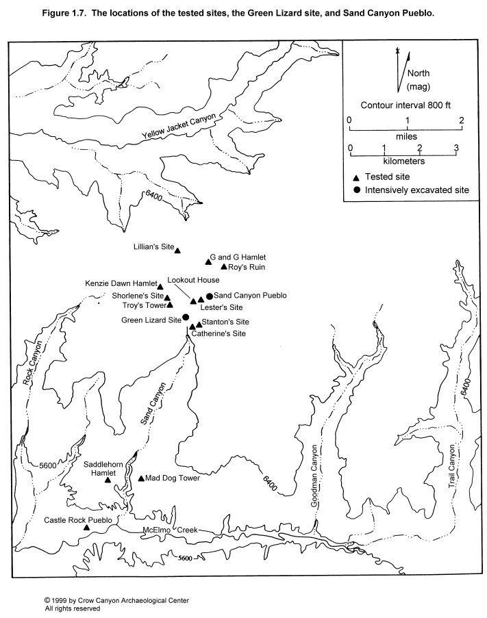
Shorlene's Site was recorded during the 1986 Crow Canyon Survey as CC86-14 and was later assigned site number 5MT3918 (Van West et al. 1987). It was test-excavated in 1988 by Crow Canyon as part of the Sand Canyon Archaeological Project Site Testing Program. Sand Canyon is the closest drainage, and Sand Canyon Pueblo, located at the head of Sand Canyon, lies just over 1 km (.6 mi) east of Shorlene's Site (Figure 1.7).
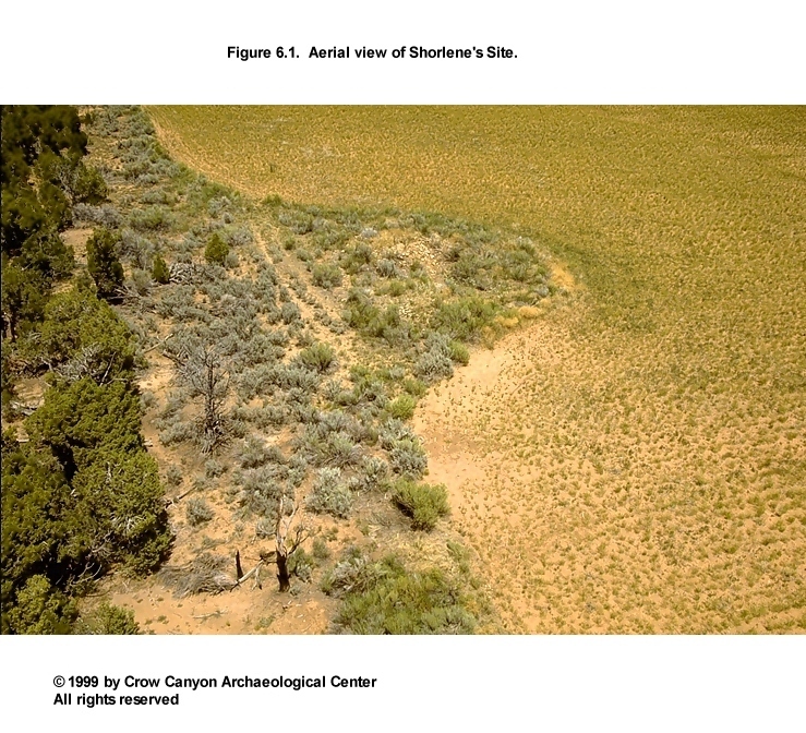
Shorlene's Site rests on a mesa top at an elevation of 2115 m (6937 ft). The site lies on the edge of the agriculturally productive Witt Series soils, and a modern agricultural field borders the north, east, and south sides of the site (Figure 6.1). Today the field is in a 10-year fallow program. To the west, the soils thin, patches of bedrock are exposed, and there is a stand of pinyon-juniper woodland.
Architectural units at Shorlene's Site are covered by a dense stand of brush, dominated by sage and rabbitbrush. The site has been heavily disturbed by vandalism. The disturbed areas are especially visible in the masonry roomblock rubble mound, where digging has exposed walls and produced large mounds of backdirt.
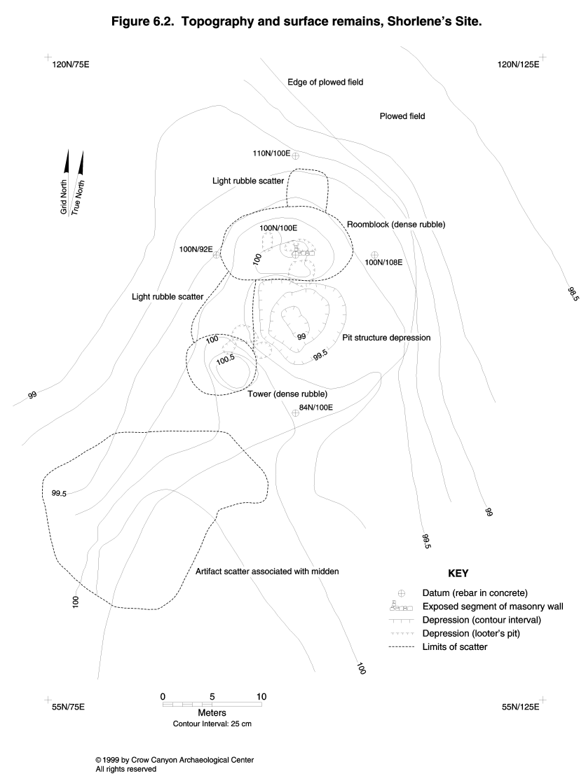
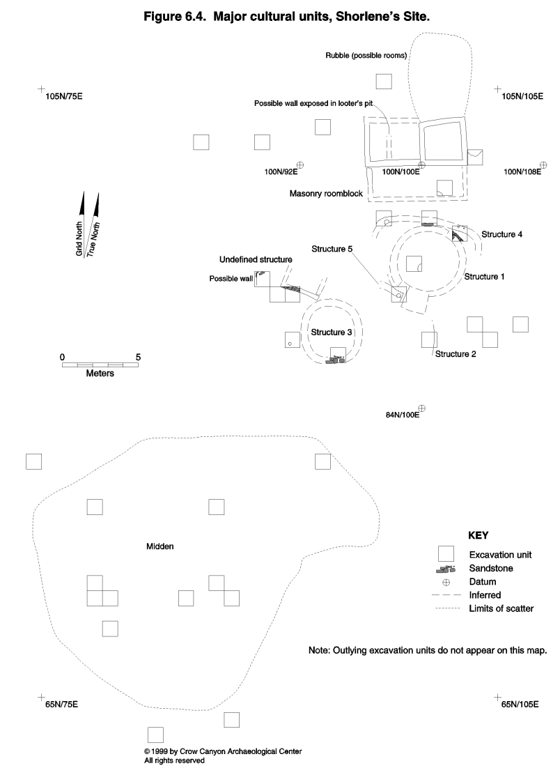
Surface remains at Shorlene's Site include a masonry rubble mound, a pit structure depression, a fallen masonry tower, and a midden (Figure 6.2). East and west of the architectural units is the inner periphery, an area characterized by low topographic rises and moderate artifact densities. The outer periphery, defined by the presence of a light artifact scatter and the absence of any surface evidence for architectural features, surrounds the more clearly defined cultural units.
The strategy used to define the sampling strata at Shorlene's was similar to that used at the other tested sites located on the mesa tops. The masonry rubble mound and the fallen tower make up Sampling Stratum 1 (Figure 6.3). Boundaries for this stratum were drawn where walls were anticipated and not at the furthest extent of the rubble. The roomblock rubble rises 60 to 70 cm, and the tower rubble is 60 cm high.
The pit structure depression, Sampling Stratum 2, is large and unusually deep, more than 50 cm. Sampling Stratum 3 consists of the courtyard area surrounding the pit structure depression and is bounded by the roomblock on the north, the tower rubble on the south, and the inner periphery on the east and west.
Sampling Stratum 4 is the inner periphery, an area of moderate artifact density, low mounds, and a light scatter of sandstone. Architectural units and features were anticipated in this sampling stratum.
Sampling Stratum 5 is the midden. A portion of the midden is in the plowed field, and a portion is outside the field. Plowing has smeared the midden boundaries and dispersed the artifact scatter.
The outer periphery is divided into two sampling strata. Sampling Stratum 6 surrounds the architectural units and inner periphery at the north end of the site. Sampling Stratum 7 surrounds the midden at the south end of the site.
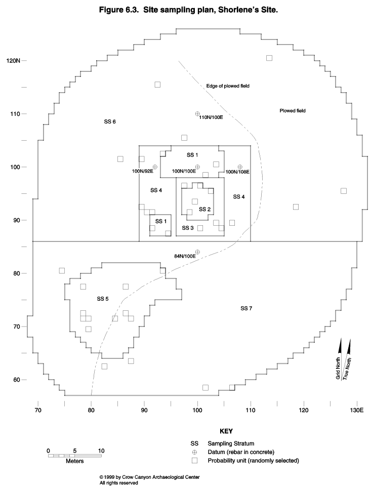
Thirty-nine probability sampling units were excavated at Shorlene's Site. Except for the wall trenching in the roomblocks, no judgmentally located sampling units were excavated. Figure 6.4 illustrates the major cultural units at Shorlene's Site as determined by the Testing Program. These units date to several periods of occupation. The masonry roomblock, tower (Structure 3), and kiva (Structure 1) date to the late Pueblo III period, probably between A.D. 1180 and 1225. Three earlier pit structures (Structures 2, 4, and 5) were also found. Structure 4 burned and has been tree-ring dated to the A.D. 650-700 period (Basketmaker III). The types of pottery found in Structure 2 indicate that it, too, dates to the Basketmaker III period. The date range for Structure 5 is less clear, but it is stratigraphically earlier than Structure 1. All of these structures are evidence that Shorlene's Site functioned as a habitation during both the Basketmaker III and Pueblo III periods. Small amounts of Pueblo I and II pottery are present at the site, indicating that there may have been limited use of the site during these periods as well.
The Shorlene's Site grid was oriented along the walls in the masonry roomblock; grid north at Shorlene's Site is 12 degrees 30 minutes west of true north. Much of the roomblock was exposed by vandalism, and testing crews swept and troweled wall alignments to further refine the site layout. Vertical Datum A, given an elevation of 100 m, is on top of the 100N/100E rebar.
The following descriptions are organized by sampling stratum. Cultural units identified are discussed within each sampling stratum.
Surface Structure Area (Sampling Stratum 1)
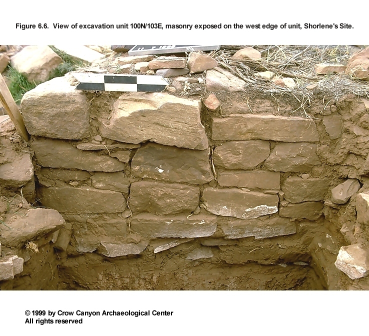
Sampling Stratum 1 includes the masonry roomblock and the masonry tower. The boundaries of this sampling stratum were drawn where the walls of the surface rooms and tower were anticipated, not around the farthest extent of the surface rubble. Sampling Stratum 1 is composed of 83 sampling units, four of which (100N/103E, 98N/101E, 88N/91E, and 87N/94E) were excavated (Figure 6.3).
Two of the excavated sampling units lie in the rubble area associated with the masonry roomblock. One of these sampling units (100N/103E) appeared to be outside any room, and it could not be determined if the other unit (98N/101E) was inside or outside a room. The other two sampling units landed near the tower. One of these (88N/91E) fell just outside the tower; the other (87N/94E) fell on top of the south wall of the tower. The tower was provenienced as Structure 3. Excavations associated with the tower are described first, followed by a description of the excavations in the masonry roomblock.
Structure 3 (Tower)
Structure 3 (Figure 6.5) is a masonry tower located southwest of the masonry pit structure, Structure 1. The south wall of the tower was exposed in sampling unit 87N/94E, and two other probability sampling units, 88N/91E in Sampling Stratum 1 and 91N/91E in Sampling Stratum 4, fell just outside the tower, helping to define the size of Structure 3 (Figure 6.3 and Figure 6.4). The diameter of Structure 3 is estimated on the basis of limited testing to be 3.50 m.
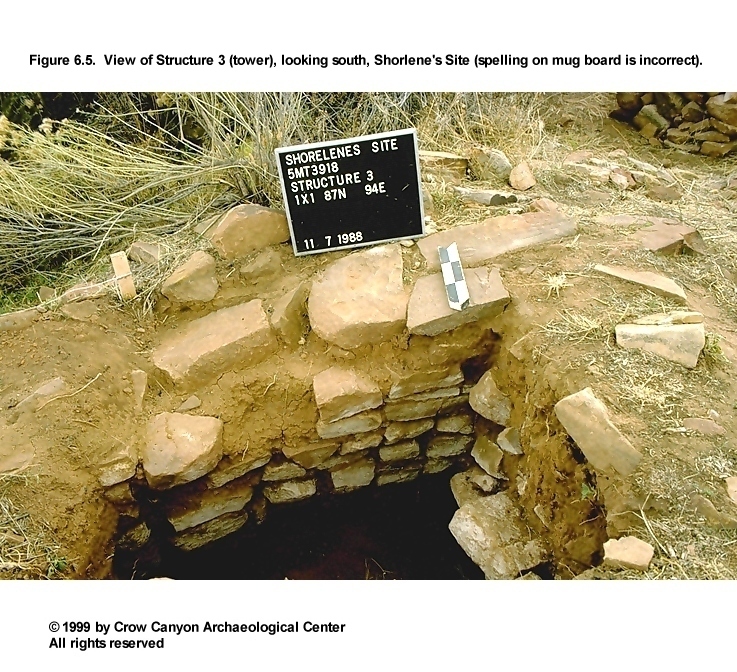
Construction
Walls. The portion of the south wall of Structure 3 exposed in unit 87N/94E was constructed with sandstone blocks and measured 66 cm high and 41 cm thick. The cross section reveals both double-stone and double-bonded construction. The walls are semi- to fully coursed, with large stones on the outside of the wall and smaller stones on the inside. Shaping of the stones was minimal, but some rough flaking and pecking was noted. No plaster was observed, and chinking was not present. Joints between masonry courses are 1 to 2.5 cm thick, and the mortar, which resembles sterile B-horizon sediments, is a red brown silty clay loam with no inclusions.
Floor. The floor of Structure 3 is located just below the base of the masonry walls and was constructed of thin sandstone slabs. These slabs cover most of the exposed floor, but they do not fit tightly together. A large flake and two corrugated sherds were found on this surface.
Roof. There was no evidence of the Structure 3 roof. Wall thickness suggests that the roof, if present, was supported by the walls. The absence of roof fall suggests that either there was no roof or the roof timbers were salvaged when the tower was abandoned.
Dating
No absolute dates were obtained for Structure 3. The masonry construction of Structure 3 indicates that it is a part of the Pueblo III component of Shorlene's Site. A Pueblo III White Painted sherd was found in the fill below the tower floor, supporting the interpretation that this structure was built during the Pueblo III occupation of Shorlene's Site.
Stratigraphy
A 7-cm-thick deposit of red brown silty clay loam was found above the floor of Structure 3. It was not clear if this stratum consisted of collapsed roof construction sediment or was sediment deposited naturally after Structure 3 was abandoned. Wall fall, 65 cm thick, fills the remainder of Structure 3.
Interpretations
Structure 3 is a circular masonry tower. The amount of wall fall inside and outside the tower suggests that it was one story high. The limited testing provided too little data to allow an interpretation of how the tower was used.
Sampling Unit 88N/91E
This sampling unit is located just outside and to the west of Structure 3 (Figure 6.3). Wall fall, which began at the modern ground surface, was 55 cm thick on the east side of the sampling unit and 26 cm thick on the west side. Wall fall was excavated in two strata: Stratum 1 was wall fall in a brown silt matrix, and Stratum 2 was wall fall in a red brown silty clay loam matrix. The red brown matrix may be eroded mortar.
A discontinuous ash lens was discovered at the base of the wall fall layer. This lens may represent an extramural surface that was used during the last period of occupation at Shorlene's Site.
Below this possible surface is Stratum 3, a 15-cm-thick stratum of gray brown loam containing numerous artifacts. This appears to be a cultural refuse deposit, and it overlays a red brown silt. The stratigraphic contact between Stratum 3 and the red brown sediments may be another extramural surface--a cluster of bones and a large core were found lying on this contact.
Ninety-one sherds were recovered from Stratum 3. Decorated white ware types include Pueblo II White Painted (N = 1), Mesa Verde Black-on-white (N = 2), and Late White Painted with carbon paint (N = 19). Indeterminate Plain Gray (N = 2) and Indeterminate Local Corrugated Gray (N = 32) were also present. The Indeterminate Plain Gray sherds could be either Basketmaker III or Pueblo I pottery; the corrugated sherds could be either Pueblo II or Pueblo III pottery. The assemblage is predominantly late, and it is likely that the majority of Stratum 3 accumulated during the Pueblo III period. In addition to the pottery, several tools were found in Stratum 3. Complete and fragmentary tools include one two-hand mano, two cores, and six modified bones. A piece of petrified wood that had been ground into an oval disk was also found.
Below Stratum 3 was a 5-cm-thick deposit of red brown silty clay loam with charcoal flecks; this was excavated as Surface 1 in this sampling unit. Excavation of this red brown stratum stopped when the cultural inclusions were no longer present and the sediments were determined to be the sterile B horizon that underlies the entire site. This surface was interpreted as the prehistoric ground surface at the time the site occupation began.
Feature 2 (Pit)
A small pit feature was found at the stratigraphic contact with the sterile B horizon (Figure 6.4). This pit, provenienced as Feature 2 in Sampling Stratum 1, is 18 cm in diameter and 14 cm deep. The fill inside the pit was similar to Stratum 3. The location of this feature, at the contact with sterile sediments, suggests that it dates to an early occupation of Shorlene's Site; however, corrugated sherds and a Pueblo III White Painted sherd found in the fill indicate that the pit may have filled during the Pueblo III occupation. The pit feature may have originated higher than the contact with the sterile B horizon, and we could have missed the top of it during excavation. If this was the case, the feature might date to the Pueblo III period, as suggested by the pottery in the fill. How this feature was used is unknown.
The Masonry Roomblock
Two sampling units, 100N/103E and 98N/101E, were excavated in the rubble mound of the masonry roomblock. The masonry roomblock has been heavily vandalized; 100N/103E lies adjacent to a pot hole, and 98N/101E lies near a mound of backdirt from pot-hunting excavations. Excavation of sampling unit 100N/103E exposed the east wall of the roomblock (Figure 6.6). Sampling unit 98N/101E may be inside a room, but this could not be positively determined.
Construction
Walls. The exposed portion of wall, which measures 62 cm high and 38 cm wide, consists of fully coursed masonry, double-stone wide. The joints between the masonry courses are .5 to 3 cm thick, and a few of the larger joints have chinking. Mortar is a brown fine sandy loam. The outside face of the wall was constructed of large stones; the interior face appears to be constructed of smaller stones. The wall stones were minimally shaped by pecking and flaking, except the corner stones, which were heavily pecked.
Sampling Unit 100N/103E
Excavation unit 100N/103E, just outside of the roomblock, consists of three strata. Stratum 1 is a layer of wall fall, 45 cm thick. Wall fall ended 4 cm above the base of the masonry wall. Stratum 2 is a 37-cm-thick deposit of brown to red brown silt loam to silty clay loam. The top of Stratum 2 appears to be the extramural surface associated with the use of the roomblock. Stratum 2 is the stratum of fill that the masonry roomblock was built on. Stratum 2 may be a mixture of sediment that accumulated during an early occupation at Shorlene's Site and fill that was collected to create a level foundation for the roomblock construction. Stratum 3 is a deposit disturbed by rodents, similar in color and texture to Stratum 2. Stratum 3 ranges from 10 to 28 cm thick and extends down to the contact with the sterile B horizon. A portion of a large pit feature, Feature 3, was found at the contact with the sterile sediments.
Feature 3 (Pit). This feature is a small portion of a large pit that extends outside the sampling unit (Figure 6.4). It is not clear if this is a Puebloan pit feature or if it is a large rodent disturbance. The pit is amorphous in plan view, with a basin-shaped profile. The looseness of the fill and the shape of the pit in plan view indicate that the feature was at least partly disturbed by rodents, but the basin-shaped profile suggests that this feature is indeed a Puebloan pit. The feature contained a peckingstone, two pieces of chipped-stone debris, an animal bone, and seven sherds. Decorated pottery includes Late White Painted sherds with carbon paint, indicating that this feature probably filled during the Pueblo III period.
Sampling Unit 98N/101E
Stratum 1 in this sampling unit was a 57-cm-thick deposit of pot hunter's backdirt, consisting of sandstone rubble in a red brown silt loam matrix. A Pepsi can found at the base of Stratum 1 indicates the location of the ground surface before the pot hunter's backdirt was deposited. Stratum 2 is dense wall fall, 26 cm thick. Stratum 3 is a red brown silty clay loam, 11 cm thick, which overlies the sterile B horizon. A portion of a pit feature, Feature 1, was found in the southwest corner of 98N/101E. No clearly defined cultural surface could be identified in this unit, and it is not clear if this unit is inside or outside a masonry room.
Feature 1 (Pit). This feature, only a portion of which fell inside the sampling unit, appears to be a bell-shaped pit (Figure 6.4). The exposed portion measures 76 cm deep and 41 cm wide. Fill inside the feature consists of a single stratum of red brown sandy loam with charcoal flecks, sandstone, and artifacts. It is not clear if this is a natural deposit or secondary refuse deliberately deposited to fill the feature; artifacts are plentiful in the fill, indicating that it may be a refuse deposit.
Pottery in the fill totals 37 sherds, including a Pueblo III White Painted sherd and two Late White Painted sherds with carbon paint, which indicates that the feature probably filled during the Pueblo III occupation of Shorlene's Site. Other artifacts in the fill include a complete two-hand mano, a fragmentary two-hand mano, a ground-stone tool fragment, an animal bone, and 28 pieces of chipped-stone debris.
Interpretations
Vandalism had resulted in the exposure of wall alignments that could be further followed by sweeping and limited troweling. Two rooms were clearly defined by this procedure (Figure 6.4). A north-south wall abuts the southwest corner of these two contiguous rooms, and this probably represents the west wall of a front room. Troweling and sweeping failed to expose the east or south walls of this front room.
Sandstone rubble was dense to the north of the well-defined rooms, but no wall alignments could be located. A poorly preserved room may be present in this area, or the rubble may have been deposited by pot hunters.
Excavation in Sampling Stratum 1 encountered a refuse stratum outside the tower and refuse-filled pits beneath the roomblock rubble mound. Consequently, a relatively large number of artifacts were recovered from Sampling Stratum 1 compared with the quantity of artifacts recovered from the surface architecture sampling strata at the other tested sites. Twenty-six complete and fragmentary tools, 205 pieces of chipped-stone debris, and 627 sherds were recovered from Sampling Stratum 1 excavations at Shorlene's Site. Sherds that predate the Pueblo III occupation include 60 Indeterminate Plain Gray, two Early White Painted, one Early White Unpainted, one Pueblo II White Painted, and one Late White Painted with mineral paint. There were 293 Indeterminate Local Corrugated Gray sherds that could be either Pueblo II or III pottery. Decorated white ware pottery that dates to the Pueblo III period includes nine Mesa Verde Black-on-white, 11 Pueblo III White Painted, and 82 Late Pueblo III sherds with carbon paint.
The Pit Structure and Courtyard Areas (Sampling Strata 2 and 3)
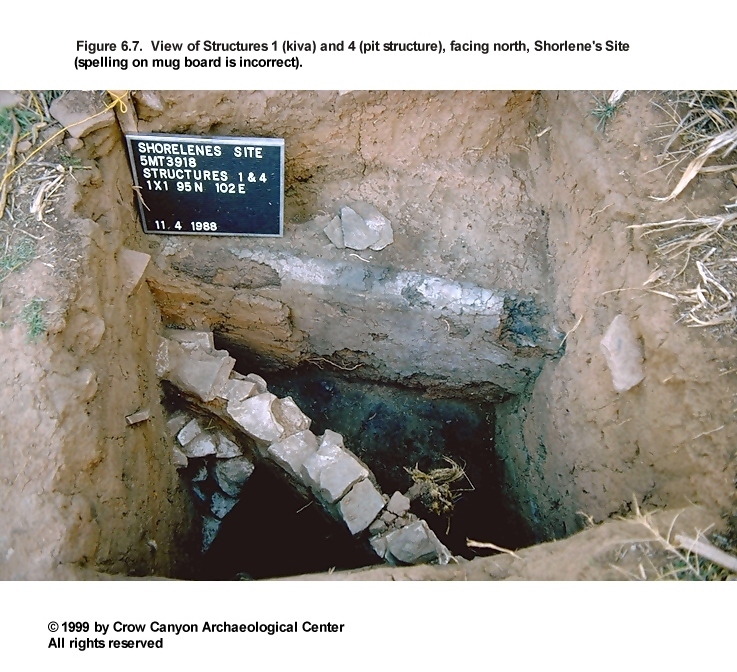
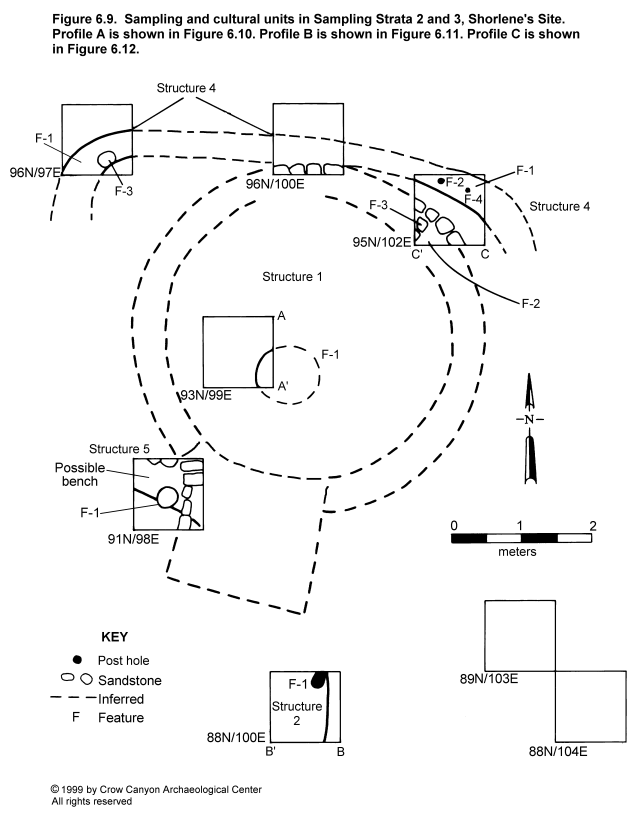
Sampling Strata 2 and 3 consist of the pit structure depression and the courtyard surrounding it. Sampling Stratum 2 contains 36 sampling units, and Sampling Stratum 3 contains 63 sampling units. Four sampling units were excavated in each sampling stratum (96N/100E, 95N/102E, 93N/99E, and 91N/98E in Sampling Stratum 2, and 96N/97E, 89N/103E, 88N/104E, and 88N/100E in Sampling Stratum 3 [Figure 6.3]). Four pit structures, Structures 1, 2, 4, and 5, were discovered in these sampling units. Identification of each of these as separate pit structures is somewhat tentative given the limited testing, but each of the floors is at a different elevation. The floors of Structures 1, 2, 4, and 5 are at 97.06 m, 98.32 m, 98.12 m, and 97.66 m, respectively (all elevations are relative to Vertical Datum A, which was arbitrarily assigned an elevation of 100 m).
Each of the Sampling Stratum 2 sampling units encountered a portion of Structure 1, the masonry-lined pit structure associated with the Pueblo III occupation at Shorlene's Site (Figure 6.4). Only 93N/99E lies completely inside Structure 1; the remainder fall around the perimeter of the structure, exposing the top of the masonry upper lining wall. The Sampling Stratum 2 sampling units located two additional pit structures, Structure 4 in 96N/100E and 95N/102E and Structure 5 in 91N/98E. Structures 4 and 5 are earlier, as the construction of Structure 1 truncated the fill sequence of both of these pit structures. Structure 4 was also encountered in Sampling Stratum 3 sampling unit 96N/97E.
A fourth pit structure, Structure 2, was discovered in sampling unit 88N/100E. Located within this sampling unit are a segment of the earthen east wall, a portion of the floor, and a post hole associated with the floor. The stratigraphic relationship of Structure 2 to the other pit structures is not known. The Structure 2 floor is at a different elevation, and its fill sequence was different when compared with the other pit structures identified at Shorlene's Site. Therefore, Structure 2 is interpreted as a separate structure.
Structure 1
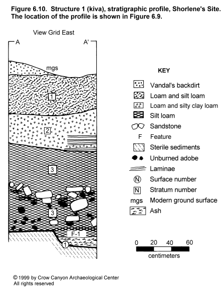
Structure 1 is an unburned, masonry-lined pit structure that dates to the Pueblo III occupation of Shorlene's Site (Figure 6.7, Figure 6.8, and Figure 6.9). Three of the sampling units overlapped portions of the north and south walls of Structure 1, allowing us to estimate the pit structure dimensions. Diameter across the lower main chamber is approximately 4.00 m; the length of the structure above the bench from the north wall to the back of the southern recess is approximately 6.50 m. The floor of Structure 2 is 2.00 m below the estimated prehistoric ground surface.
Construction
Walls. The masonry upper lining wall was observed in sampling units 91N/98E, 95N/102E, and 96N/100E. The lower walls of the main chamber were not exposed in the sampling units. The wall in 91N/98E is interpreted as the west wall of the southern recess; this sandstone wall was one stone wide, semi- to fully coursed, and measured 92 cm high and 19 cm thick. The upper lining wall exposed in 95N/102E measured 60 cm high and 12 cm thick. The faces of the stones were not extensively shaped, but there appears to have been some flaking to reduce the stones to a uniform shape. Portions of the bench and a pilaster were found associated with the upper lining walls.
Feature 2 (Bench): A small portion of the Structure 1 bench was exposed in 95N/102E. The bench surface ranges from a red brown silty clay loam, which may be a prepared surface, to a white sediment, rich in calcium carbonate (caliche), that is believed to be a use-compacted surface. There were no artifacts on the exposed portion of this feature.
Feature 3 (Pilaster): A corner of a masonry pilaster was exposed in 95N/102E. Only the lower 31 cm of the pilaster is present. A single course of pecked-block masonry remains in place, and above this is a cluster of smaller stones that appear to have been a part of the core of the pilaster. The pilaster either collapsed or was partly dismantled after Structure 1 was abandoned. The lowermost course of pilaster masonry rests on the bench, but the pilaster appears to have been constructed before the bench construction was completed, because the base of the pilaster was 3 cm below the adobe plaster of the bench surface.
Floor. The structure floor and a portion of the Structure 1 hearth were exposed in 93N/99E. The floor was constructed with a red brown, silty clay loam plaster. A corrugated sherd and a flake were the only floor artifacts recovered.
Feature 1 (Hearth): The hearth is a basin-shaped pit excavated into the Structure 1 floor. The exposed portion of the hearth measures 52 cm long, 26 cm wide, and 22 cm deep. The top of the hearth is flush with the Structure 1 floor; an adobe rim around the perimeter of the pit, which is commonly found in pit structure hearths, is not present around the Structure 1 hearth. The hearth wall was lined with adobe and oxidized from exposure to heat. Traces of an earlier burned wall were found behind the plastered walls of the hearth, and this is evidence that the hearth was remodeled at some point during the use of Structure 1.
Two strata fill the hearth. The upper fill is a 10-cm-thick stratum of brown silt loam with mottled calcium carbonate flecks; this is the same fill that covered the Structure 1 floor. A 12-cm-thick stratum of ash filled the remainder of the pit. The ash was sampled for flotation analysis (see Chapter 16), and the remainder was processed by fine-screening. Botanical remains recovered from the hearth include pine, bitterbrush/cliffrose, juniper, serviceberry/lemonadeberry, sagebrush, and mountain mahogany charcoal. Corn cupules may indicate that corncobs were burned as fuel. Cheno-am, prickly pear, grass, and purslane seeds were also found in these samples.
Roof. The Structure 1 roof was not preserved. Unburned adobe in the fill directly in contact with the floor suggests that the roof collapsed or was dismantled shortly after Structure 1 was abandoned. The roof may have been dismantled in order to salvage the timbers.
Dating
No absolute dating samples were collected from Structure 1; however, Structure 1 is aligned with the other masonry architectural features at Shorlene's Site, and together these are believed to date to the Late Pueblo III occupation of the site. Mesa Verde Black-on-white pottery was found on the site, and this indicates that the Pueblo III occupation dates sometime after A.D. 1180 (Wilson 1991). Pottery from the fill of Structure 1 is a mix of early and late types. This is discussed further in the section below on stratigraphy.
Stratigraphy
Figure 6.10 illustrates the Structure 1 stratigraphic profile. Like many of the Pueblo III pit structures sampled during the Testing Program, Structure 1 is characterized by a limited amount of stratification in the fill sequence, and an exceptionally thick deposit covering the floor.
The floor is covered by Stratum 3, a 94-cm-thick stratum of brown silt loam. Inclusions, color, and texture are similar from the top to the bottom of Stratum 3. Flecks of calcium carbonate, charcoal, burned and unburned adobe, and sandstone blocks were found in Stratum 3. The adobe and the sandstone were concentrated in the lower 55 cm of this stratum, but the calcium carbonate and charcoal were deposited uniformly. Faint laminae were observed in the portion of the profile where the sandstone was most heavily concentrated.
The absence of stratification and the uniformity in color, texture, and inclusions throughout this stratum make it appear as though it were the result of a single, rapid, depositional event; colluvial or cultural deposition is the only possibility for such a rapid accumulation of fill. The charcoal, adobe, and sandstone inclusions in Stratum 3 have unaltered angular shapes and are oriented at different angles. These observations indicate that the inclusions were not transported a great distance, did not erode during or after transport, and were probably deposited rapidly.
Adobe and sandstone directly above the floor may have accumulated as a result of the roof being dismantled to salvage roof timbers. There was no evidence of roof timbers or the decomposed remains of roof timbers in Stratum 3. Faint laminae were observed in the sediments that surround the sandstone. This indicates there was also a small amount of water deposition in the lower portion of Stratum 3. Water deposition at Shorlene's Site would have been limited to rainfall run-off and snow melt, and it is unlikely that these would provide the velocity needed to transport the sandstone. Colluvial (falling from the roomblock or from the Structure 1 roof) or cultural (material deliberately thrown into the structure perhaps during the dismantling of the roof to salvage the timbers) processes must have deposited the sandstone.
Pottery from this stratum is a mix of early and late types. Indeterminate Plain Gray is present in the upper stratum of hearth fill, and in the fill 5 cm above the floor. Early White Painted is also present in the fill 5 cm above the floor. Corrugated Gray is present in these same contexts. In the remainder of Stratum 3, Indeterminate Plain Gray, Mesa Verde Corrugated Gray, Late White Painted with both mineral and carbon paint, and Early White Painted are among the types present. The presence of the late types (Mesa Verde Corrugated Gray and the Late White Painted with carbon paint) indicates that the structure was filling during the Pueblo III period, but earlier pottery was mixed in with this deposit. It is possible that early sherds were incorporated into roof-construction sediment and were deposited in the sediments above the floor when the roof was disassembled to salvage roof timbers.
Stratum 2 is a laminated deposit that lies above Stratum 3. The laminae are sorted by particle size, and they are of different colors, ranging from red brown silty clay loam to dark brown loam. The laminae "fine upward" so that the coarsest sediment lies at the base of the laminae, and the finer particle sizes are found toward the top of the laminae. Stratum 2 is interpreted as sediment and organic materials that were transported and deposited by water.
Stratum 1 is a dark brown loam to silt loam. Inclusions were rare within this stratum. The dark brown color is believed to have been produced by the accumulation and decay of organic material within this stratum. Like Stratum 2, Stratum 1 is interpreted as a natural, postabandonment deposit.
Interpretations
Structure 1 is a masonry-lined pit structure that dates to the Pueblo III occupation at Shorlene's Site. The pit structure has architectural attributes characteristic of structures traditionally interpreted as Mesa Verde-style kivas. Structure 1 was constructed inside at least two earlier pit structures, Structures 4 and 5. Limited testing in Structure 1 makes it difficult to determine how the structure functioned. Sampling units that fell around the perimeter of Structure 1 indicate that the complex kiva architecture that characterizes Sand Canyon Pueblo kivas (Bradley 1992a, 1992b) is not present in Structure 1. This may indicate that Structure 1 was not as specialized for ritual activity as the Sand Canyon Pueblo kivas. Structure 1 stratigraphy indicates that the roof timbers were salvaged from this structure when it was abandoned and that part of the abandoned structure was deliberately filled.
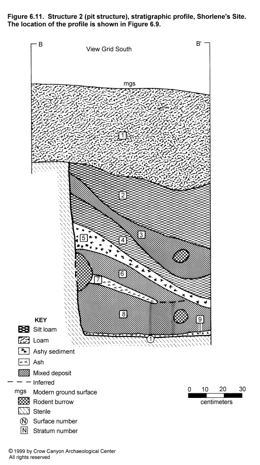
Structure 2
Structure 2 is an unburned, earth-walled pit structure discovered in sampling unit 88N/100E (Figure 6.4). The only known dimension for Structure 2 is the depth; the floor is 1.49 m below the modern ground surface. The floor lay 1.08 m below the estimated prehistoric ground surface, but the location of prehistoric ground surface was not entirely clear in this sampling unit. The relatively shallow depth and the earth-wall construction suggest that Structure 2 was occupied before the Pueblo III component at Shorlene's Site. A single tree-ring date of 636 vv was obtained from a piece of charcoal in the Structure 2 fill. The floor of Structure 2 is 20 cm higher than the floor of Structure 4. The difference in the elevation of the two floors resulted in the interpretation that they belong to two different pit structures. The pit structures also have dissimilar fill sequences. Still, it is possible that Structure 2 is in fact the antechamber of Structure 4 and that together they represent a large Basketmaker III pit structure.
Construction
Walls. A small segment of the east wall of Structure 2 was exposed, and it is formed of undisturbed B-horizon sediments. No trace of plaster was found on the wall. There may be a bench or a shelf at the top of the exposed wall, 96 cm above the floor, but testing was too limited to make a positive identification of this feature.
Floor. The floor is a use-compacted surface of red brown silty clay loam containing veins of calcium carbonate. Artifacts lying horizontally in an ash lens 1 cm above the floor may have been deposited during the use of the structure. These include a bone awl and an extremely thin biface fragment.
Feature 1 (Post Hole): A cylindrical post hole containing the remains of a rotting post was found adjacent to the Structure 2 east wall. The post hole measured 20 by 16 by 46 cm deep.
Roof. Feature 1 may have held a post that supported the Structure 2 roof. With the exception of this post hole, there was no other evidence of the roof or roof-support system within the examined portion of Structure 1.
Dating
Two tree-ring samples were collected from the trash fill in Structure 2. One specimen recovered from 28 cm above the Structure 2 floor produced a date of 636 vv. The shallow depth and earth-wall construction suggest that Structure 2 dates to the late Basketmaker III-early Pueblo I period (Wilshusen 1988b, 1989a). The dating of this structure is by no means certain, due to the mix of pottery found in the fill.
The types of pottery found in the fill of Structure 2 are predominantly early, including many Basketmaker III sherds. However, later types are present as well. Even more confusing, the later types are most frequent in the levels closest to the Structure 2 floor. Later types include Mesa Verde Black-on-white (N = 1), Late White Painted with carbon paint (N = 1), Late White Unpainted (N = 1), and Indeterminate Local Corrugated Gray (N = 2) from an ash lens (Stratum 9) just above the floor. The remainder of the pottery in Stratum 9 includes Early White Painted (N = 1), Early White Unpainted (N = 1), and Indeterminate Plain Gray (N = 13). The remaining late pottery was found in Strata 5 through 8 and includes Late White Painted with carbon paint (N = 8), Late White Unpainted (N = 3), and Indeterminate Local Corrugated Gray (N = 2). Early pottery found in these same strata includes Early White Painted (N = 1) and Indeterminate Plain Gray (N = 16). The upper strata (Strata 2, 3, and 4) contain only early pottery, including Chapin Gray (N = 2), Indeterminate Plain Gray (N = 39), Basketmaker Mudware (N = 1), Early White Painted (N = 5), and Early White Unpainted (N = 3).
To summarize, the one tree-ring date, the depth of the structure, and the earth-wall construction all indicate that this is a Basketmaker III-Pueblo I structure. This interpretation is questionable, however, given the presence of late pottery in the lower structure fill. Rodent disturbance was extensive in this sampling unit, but it is not clear if this could explain the presence of all of the late pottery found in the lower fill. Further excavation would be needed to resolve the dating of this structure.
Stratigraphy
Figure 6.11 illustrates the Structure 2 stratigraphic profile. In contrast to the Structure 1 profile, the Structure 2 profile is characterized by a great deal of stratification. The distinct strata indicate that a number of depositional events were responsible for the filling of the structure. The strata are basin-shaped and slope down from the wall toward the center of the structure, which indicates that the roof was gone and that fill was being deposited from around the perimeter of the structure.
The Structure 2 floor was covered by Stratum 9, a thin lens of ashy sediments. Stratum 9 was a maximum of 3 cm thick. It is not clear if Stratum 9 is a deposit associated with the use of Structure 2 or is secondary refuse deposited after Structure 2 was abandoned.
Stratum 8, a 28-cm mottled deposit lying just above Stratum 9, is a mixture of red brown silty loam and dark gray brown ashy sediments. Stratum 8 is a mixed deposit, but it is not clear if it includes naturally deposited sediment and secondary refuse, or if it consists of secondary refuse and portions of the Structure 2 roof.
Stratum 7 is a 5-cm-thick ash lens interpreted as secondary refuse. Stratum 6 is a 12-cm-thick mixed deposit containing dark gray ashy sediments and red brown silt loam with charcoal flecks. Stratum 6 may have accumulated as a combination of secondary refuse and naturally deposited sediment.
Stratum 5 is 14 cm thick adjacent to the wall and 5 cm thick toward the center of the structure. It consists predominantly of gray brown ashy sediments but is mottled with bits of charcoal and adobe. Stratum 5 is believed to be secondary refuse.
Stratum 4 is a 6- to 16-cm-thick layer of red brown silt loam interpreted as naturally deposited sediment. Stratum 3 is a 5- to 14-cm-thick layer of gray brown loam mottled with chunks of adobe and red brown silt loam. Stratum 3 is interpreted as a mixed deposit containing both secondary refuse and naturally deposited sediment.
Stratum 2 is an 8- to 34-cm-thick deposit of red brown silt loam heavily mottled with inclusions. Bits of charcoal, adobe, and sandstone are mixed in with the sediment. Stratum 2 is interpreted as primarily a natural deposit.
Stratum 1 is a brown to red brown loam to silt loam with virtually no inclusions. Stratum 1 is interpreted as a naturally deposited stratum that may have accumulated during a period of site abandonment.
Interpretations
Structure 2 is an earth-walled pit structure just over 1.00 m deep. The pit structure depth, the earth walls, and a single 636 vv tree-ring date suggest that Structure 2 was occupied in the late Basketmaker III to early Pueblo I times. Wilshusen (1989a:827) has argued that ancient Puebloan pit structures get deeper through time. Structures approximately 1.00 m deep date to the late Basketmaker III (A.D. 600-700) period in the Dolores River valley (Wilshusen 1988b:615, 1989a:827). The presence of Pueblo III pottery in the lower fill, however, contradicts this interpretation. Additional excavation is needed to resolve the dating of this structure.
The stratification observed in the Structure 2 fill sequence contrasts with the relatively unstratified fill sequence described for Structure 1. The fill of Structure 2 reflects numerous distinct depositional events, including use of the abandoned pit structure depression as a midden and the accumulation of fill as a result of natural processes. Use of the Structure 2 depression as a midden indicates that the occupation of Shorlene's Site continued after Structure 2 was abandoned.
The fill sequence and floor elevation in Structure 2 differ from what was observed in the other pit structures at Shorlene's Site, and therefore Structure 2 is interpreted as a separate pit structure. The Structure 2 floor, however, is only 20 cm higher that the Structure 4 floor, so it is possible that Structure 2 is an antechamber for Structure 4 and that together they represent a large Basketmaker III pit structure. The single tree-ring date from Structure 2 is similar to the tree-ring dates from Structure 4. However, the lack of trash fill in Structure 4, the fact Structure 4 burned and Structure 2 did not, argues against these being the same structure.
Structure 4
Structure 4 is a large, relatively shallow, burned, earth-walled pit structure encountered in sampling units 95N/102E, 96N/100E, and 96N/97E (Figure 6.4 and Figure 6.7). The excavation of these sampling units uncovered portions of the Structure 4 north wall, a bench, and portions of the main chamber just inside the north wall. Structure 4 burned and had entirely filled before Structure 1 was constructed inside it. Limited testing did not determine the exact dimensions of Structure 4, but it could be over 6.50 m wide, and the floor is 80 cm below the estimated prehistoric ground surface.
Construction
Walls. The walls of Structure 4 were constructed by excavating a pit into the sterile B-horizon sediments. Portions of the earth wall were covered by a fine sandy plaster. A bench was found at the top of this wall, and several features were associated with the bench.
Feature 1 (Bench): A bench was exposed in 95N/102E and in 96N/97E; the bench appears to have been destroyed in 96N/100E by the construction of Structure 1. The bench surface is located 60 cm above the Structure 4 floor and approximately 20 cm below the prehistoric ground surface. Width of the bench is not known. Three features (Features 2, 3, and 4) are located on the bench.
Features 2 and 4 (Post Holes): Two shallow post holes were discovered on the bench in 95N/102E. Feature 2 was 11 cm in diameter and 6 cm deep, and Feature 4 was 8 cm in diameter and 3 cm deep. Remnants of a burned post were found in Feature 2. These features were 27 cm apart. They are interpreted as sockets for stringer posts incorporated into the Structure 4 roof.
Feature 3 (Pit): A shallow pit feature was defined on the bench in 96N/97E. This pit feature measures 30 by 24 by 13 cm deep.
Floor. The floor was constructed by leveling the sterile sediment and covering it with a thin coat of plaster.
Roof. The roof of Structure 4 burned, and burned roof timbers lay on the bench and in the fill of the main chamber. The roof design probably included upright posts set into the Structure 4 floor, which supported a framework of primary and secondary beams. The stringer posts, or "secondary leaners," set into the bench were probably attached to this framework of primary and secondary beams. This beam framework would have been covered with smaller vegetal closing material, and this in turn would have been covered with adobe. Lancaster and Watson (1954:13) illustrate a possible reconstruction for this type of roof design, and Wilshusen (1988b) discusses pit structure roofing in greater detail.
Dating
Thirteen tree-ring samples were collected from the fill of Structure 4. Three of these samples produced dates: A.D. 647 +vv, 655 v, and 656 vv. On the basis of these dates, it is inferred that Structure 4 was constructed after A.D. 656 but probably sometime near this date. The depth of Structure 4 would make it analogous to Dolores-area pit structures that date between A.D. 600 and 700 (Wilshusen 1988b:615, 1989a:827).
Stratigraphy
Structure 4 fill consists of a single stratum of burned roof fall (Figure 6.12). Burned timbers were found lying directly on the bench and floor, indicating that the fire took place shortly after Structure 4 was abandoned. Structure 1 was constructed inside Structure 4 an estimated 500 to 600 years after Structure 4 burned. A brown loam A horizon with no inclusions overlay both Structure 4 and Structure 1. This is interpreted as a deposit that accumulated primarily after Shorlene's Site was abandoned.
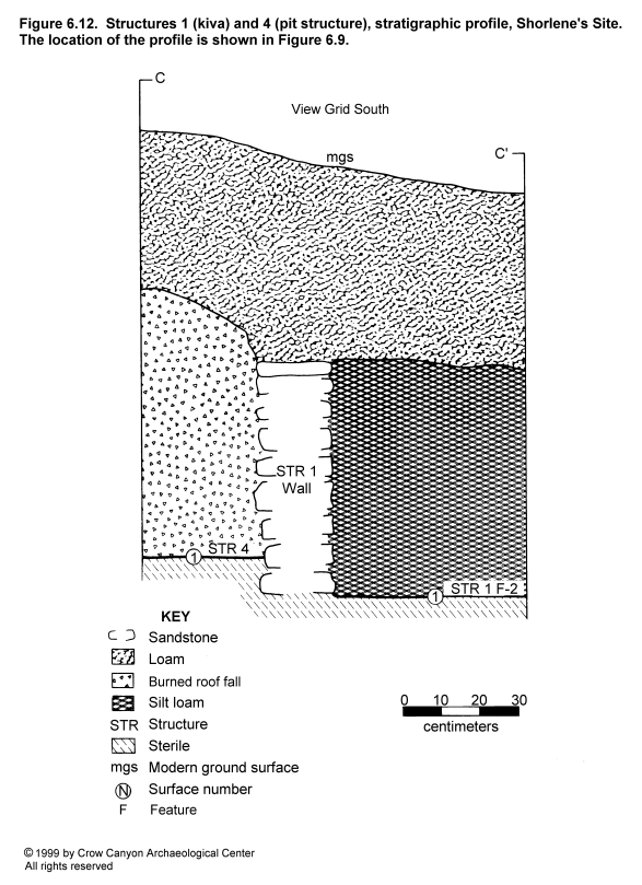
Interpretations
Structure 4 is a shallow, earth-walled pit structure that burned at or near the time of abandonment. Tree-ring dates and construction style indicate that Structure 4 was probably constructed between A.D. 650 and 700. Pit structures from this period are traditionally interpreted as pithouses that served as domiciles. Basketmaker III pit structures can be quite large and consist of a main chamber and an antechamber (Brisbin 1986:854; Brisbin and Varien 1986:140; Lancaster and Watson 1954:9). It is possible that Structure 4 is the main chamber and Structure 2 the antechamber of the same pit structure. The differences in floor elevation (20 cm) and fill sequences between the two (Structure 4 is burned, Structure 2 is partly trash filled) may be explained by their being separate chambers. Further excavation would be needed to determine the relationship between Structures 2 and 4.
Five to six centuries after Structure 4 was abandoned, Structure 1, a Pueblo III masonry-lined pit structure, was constructed within the Structure 4 main chamber. The location of Structure 1 inside Structure 4 does not seem to be accidental; a recently excavated site located 20 km (12 mi) northwest of Shorlene's site also had a Pueblo III masonry-lined pit structure constructed into a burned Basketmaker III pit structure (Morris 1991b). The importance of the superposition of structures and occupations is discussed further in the Shorlene's Site summary.
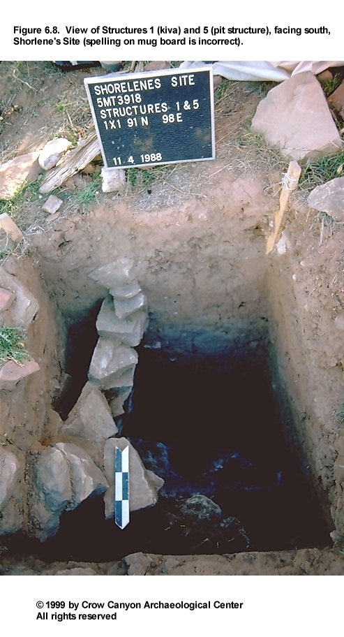
Structure 5
Structure 5 was discovered in sampling unit 91N/98E (Figure 6.8 and Figure 6.9). Only a small portion of this pit structure was uncovered, and the limited exposure makes interpretation difficult. Structure 5 is located in the southwest corner of the sampling unit, and the back side of the Structure 1 masonry lining wall was found in the northeast corner. Structure 1 construction appears to have truncated the Structure 5 fill sequence. None of the Structure 5 walls were located, and it is possible that Structure 1 wall construction removed a portion of the Structure 5 wall. The floor of Structure 5 is at a different elevation than any of the other pit structure floors.
Construction
Floor. The floor of Structure 5 is an adobe-plastered surface over a stratum of caliche. No artifacts were found on the Structure 5 floor, but an Indeterminate Plain Gray sherd and a complete stone pendant were found in the level 5 cm above the floor.
The floor existed on two levels, one 28 cm higher than the other. The upper level, which also has adobe plaster on top of a caliche horizon, may be a low bench. If this is a bench, then its location and curvature suggest that the sampling unit is near the northeast wall of Structure 5 (Figure 6.9).
Feature 1 (Pit): Feature 1 is a cylindrical pit located at the edge of the possible bench. The shape of this feature suggests that the pit could be a post hole. Feature 1 measures 27 cm in diameter and 56 cm deep. The fill consisted of a gray brown to brown loam, the same fill that covered the Structure 5 floor. This suggests that the feature was open when Structure 5 was abandoned, so if Feature 1 was a post hole, the post must have been removed when the structure was abandoned.
Dating
Structure 5 is stratigraphically earlier than Structure 1. Three small tree-ring samples were collected from Stratum 3 of Structure 5. A single tree-ring date of 653 vv was obtained for a sample located 67 cm above the floor. This is similar to the tree-ring dates obtained for samples collected from Structures 2 and 4.
The floor of Structure 5 is estimated to be between 1.20 and 1.40 m below the prehistoric ground surface (the prehistoric ground surface in this sampling unit was not marked by an abrupt stratigraphic break). Structures of this depth in the nearby Dolores area are most common during late Basketmaker III and early Pueblo I times, between A.D. 700 and 780 (Wilshusen 1988b:615, 1989a:827).
The construction of Structure 1 probably mixed the Structure 5 fill in 91N/98E, making the interpretation of the pottery in the fill difficult. As in Structure 2, there is a mix of early and late pottery types in the levels just above the floor. Also as in Structure 2, earlier pottery, including Basketmaker III and Pueblo I types, is most common. The early sherds in the level immediately above the floor include one Early White Painted, one Early White Unpainted, and three Indeterminate Plain Gray, one of which has a fugitive red slip. Late pottery includes one Late White Unpainted sherd. Upper levels contain both early and late sherds.
The tree-ring date, structure depth, and pottery near the floor suggest a late Basketmaker III-Pueblo I date for Structure 5. The late pottery in the fill, however, makes this interpretation debatable. Additional excavation would be needed to resolve the dating of this structure.
Stratigraphy
Stratum 4 is a gray brown to brown loam covering the Structure 5 floor. Flecks of calcium carbonate are the main inclusions. The color suggests that this stratum contains ash and that it therefore consists of trash thrown into the abandoned structure. Artifact density is not high, however, and large pieces of charcoal are absent. The identification of this stratum as trash may therefore be incorrect. The absence of sorting by particle size does suggest, however, that Stratum 4 is a cultural, rather than a natural, deposit.
Stratum 3 is similar to Stratum 4 except it is slightly lighter in color, has slightly more fine sediment, and has more inclusions, including calcium carbonate, charcoal, unburned adobe, and small (5 to 10 cm) pieces of sandstone. This stratum may represent secondary refuse.
Stratum 2 is a mixed deposit. The red brown silt loam was mottled with brown loamy sediments, and inclusions were scarce. The depositional processes that resulted in the accumulation of Stratum 2 are not known.
Stratum 1 is a dark brown loam. Stratum 1 appears to be vandal's backdirt from a disturbed area to the southwest.
Interpretations
Structure 5 is a pit structure occupied sometime before the construction of Structure 1. Alternative interpretations were considered but rejected. For example, it could be argued that Structure 5 is part of either Structure 2 or Structure 4, other pit structures identified on the site--a single tree-ring date from the Structure 5 fill is similar to tree-ring dates from Structures 2 and 4. The main argument against these being the same structure is the observation that the floor of Structure 5 is at a different elevation than the floors in the other pit structures. It is also possible that Structure 5 is a corner room associated with Structure 1. Kivas at Sand Canyon Pueblo often have rooms attached to the southeast and southwest corners. However, in the case of Structures 1 and 5 at Shorlene's, this is thought to be unlikely because the bench and pit feature found in Structure 5 are not features found in any of the Sand Canyon corner rooms. Structure 5 therefore appears to be a pit structure associated with an occupation of Shorlene's Site that predates the late Pueblo III occupation.
Precise dating of Structure 5 is difficult. The depth of the structure and a single tree-ring date suggest that Structure 5 dates to the late Basketmaker III or early Pueblo I periods. Much of the pottery in the fill dates to this period, but late pottery is present as well.
Sampling Units 88N/104E and 89N/103E
These two Sampling Stratum 3 units did not overlap structures. Both units were excavated to the contact with sterile sediments, at a depth of approximately 25 cm. The only stratigraphy encountered was a lens of burned adobe in 88N/104E. This 3- to 5-cm-thick lens of adobe was also found in Sampling Stratum 4 sampling unit 89N/106E. A Pueblo III-style side-notched projectile point was found 1 cm below the modern ground surface in 89N/103E.
Feature 1 (Pit)
A cylindrical pit was found at the contact with sterile sediments in 88N/104E. This pit measures 20 cm in diameter and 14 cm deep. The fill inside the feature was a red brown silt loam.
Pit Structure and Courtyard Area Artifacts
Artifact counts in the pit structure and courtyard sampling strata at Shorlene's Site are high compared with artifact counts in these same sampling strata at many of the other tested sites. This is largely attributable to the presence of refuse deposits in some of the abandoned pit structures at Shorlene's. The refuse in the pit structure fills also explains another aspect of the Shorlene's Site assemblage data, and that is the higher proportion of early pottery in these two sampling strata compared with the other sampling strata at the site. For example, Indeterminate Plain Gray accounts for 32.3 percent of sherds in Sampling Stratum 2 and 34.9 percent of the Stratum 3 totals. Indeterminate Plain Gray was the most abundant type found in Sampling Stratum 3 and the second most common type in Sampling Stratum 2 (Indeterminate Local Corrugated Gray was 36.4 percent of the Sampling Stratum 2 totals). The Indeterminate Plain Gray pottery in these two strata accounts for 40.4 percent of all the Indeterminate Plain Gray found on the site, whereas the total number of sherds from these strata makes up only 18.5 percent of the total pottery assemblage on the site. The ratio of Indeterminate Plain Gray to Indeterminate Local Corrugated Gray in Sampling Stratum 2 is 1:1.1; in Sampling Stratum 3, where Plain Gray is more plentiful than Corrugated Gray, the ratio is 1.3 Plain Gray sherds to every corrugated sherd. The same is true for Early White Painted: 44.1 percent of all the Early White Painted sherds recovered from the site come from Sampling Strata 2 and 3.
The higher percentage of earlier pottery may indicate that Structures 2 and 5 are in fact structures that date to the late Basketmaker III or early Pueblo I periods. The later pottery that is also found in the fill of these two structures may have been mixed into the earlier fills by construction activity during the Pueblo III occupation and by postabandonment disturbances, for example, animal burrowing.
Pit Structure and Courtyard Sampling Strata: Summary and Interpretations
Excavation of eight sampling units in these two sampling strata resulted in the identification of four pit structures. Structure 1 is a masonry-lined pit structure that was occupied during the Pueblo III occupation of the site. Structure 1 was constructed inside a burned Basketmaker III pit structure, Structure 4, that is tree-ring dated to the middle A.D. 600s. Two other pit structures were found; their dating is problematic, but their relatively shallow depth, their earth-wall construction, and tree-ring dates obtained for samples from their fill suggest that they are late Basketmaker III-early Pueblo I structures. As summarized above, earlier pottery is present in relatively large amounts in these structures, but later pottery is mixed in with these deposits as well. Only two of the excavated sampling units did not encounter one of the four structures listed above.
Inner Periphery (Sampling Stratum 4)
Sampling Stratum 4 is the inner periphery sampling stratum that borders the east and west sides of the main architectural units at the site (Figure 6.3). Surface remains used to draw boundaries around Sampling Stratum 4 include a low topographic rise, a light scatter of sandstone, and moderate artifact density (lower artifact density than in the midden but greater density than in other areas of the site). Sampling Stratum 4 contains 196 sampling units; six (102N/93E, 101N/89E, 92N/89E, 91N/91E, 91N/90E, and 89N/106E) were excavated.
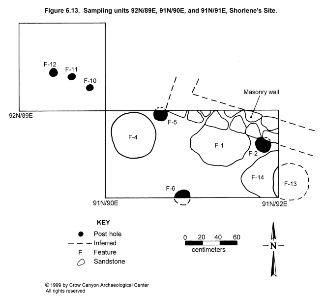
Sampling Units 92N/89E, 91N/91E, and 91N/90E
A masonry wall and a set of posts were discovered in these sampling units (Figure 6.13). The masonry wall was found along the north edge of sampling units 91N/91E and 91N/90E. The wall appears to be the south wall of a room, and the southwest corner of this room is located in 91N/90E. The room is located west of the masonry-lined pit structure, Structure 1, and adjacent to the masonry tower, Structure 3 (Figure 6.4).
In addition to the masonry wall and the posts, four large pit features were discovered in 91N/91E and 91N/90E. Although it was not apparent from the modern ground surface, this area had been vandalized; a Michelob beer bottle was found 15 cm below the modern ground surface in 91N/91E. This disturbance makes the interpretation of the stratigraphy in these units difficult. The masonry wall is described first, followed by descriptions of the posts and pit features.
Masonry Wall
The wall exposed in 91N/91E and 91N/90E has a double-stone-wide cross section, and measures 20 cm thick and 32 cm high. This wall appears to be part of a room located to the north of the sampling units. The style of construction is similar to the other late Pueblo III masonry structures on Shorlene's Site. The wall is built on top of cultural fill, which further supports the interpretation that the wall dates to the final occupation at Shorlene's Site.
Features 2, 5, 6, 10, 11, and 12 (Post Holes)
Each of these features contains the remains of a rotting post. Two of the posts, Features 2 and 5, are located adjacent to the masonry wall. The stratigraphic relationship of the wall to the posts is difficult to interpret. Feature 2 looks as if it is partly beneath the wall and therefore a part of an earlier structure, but Feature 5 originates high in the profile and could be contemporaneous with the wall.
Features 2, 5, 10, 11, and 12 lie roughly in a straight line, which suggests that they are part of the same construction (for example, a wall in a post-and-adobe room). Feature 6 is not aligned with the other posts. If Feature 6 is part of the same construction as the other posts, then the construction may be more than a single room. These posts may be associated with a post-and-adobe roomblock.
Although the rotting posts were collected for tree-ring analysis, none produced dates. Therefore, dating this construction relies on the stratigraphic position of the posts. The fact that the posts are constructed in fill indicates that they date to sometime after the earliest occupation at Shorlene's Site (that is, after the construction of Structures 2 and 4 during the Basketmaker III period). Feature 14 (described below) was found at a level below these posts, and it contained a tree-ring specimen that dates to the Pueblo III period, so it is possible that the posts date to this period as well. Further excavation would be needed to determine the type and date of construction represented by the posts.
Features 1, 4, 13, and 14 (Pits)
These pit features were discovered during the excavation of sampling units 91N/91E and 91N/90E. Feature 1 was located at the highest elevation and may have been used after the other pits. Features 4 and 13 were discovered at approximately the same elevation (below Feature 1 but above Feature 14), and the two may have been used during the same period of occupation. Feature 14 was detected near the contact with the sterile B horizon.
Feature 1 was discovered first, at the same elevation as the base of the masonry wall (99.70 m). This level is compact and may represent an extramural surface associated with the masonry wall. Feature 1 measures 65 cm in diameter and 24 cm deep. The pit has amorphous boundaries that were difficult to follow at the level of detection, but the limits became well defined 15 cm below the top of the feature. The top of the feature may have been disturbed by pot hunters or rodents. The north wall of Feature 1 extends 10 cm under the masonry wall, which suggests that the feature was used and filled before the masonry wall was built. However, it is possible that the two were used at the same time. Feature 1 was excavated into cultural fill, indicating that it was constructed after Shorlene's Site had been occupied for some time. Feature fill consisted of a red brown sandy loam with charcoal flecks, and it contained 14 pieces of chipped-stone debris and 17 sherds (eight Indeterminate Plain Gray, four Indeterminate Local Corrugated Gray, four Late White Unpainted, and one Late White Painted with carbon paint).
Feature 4 is a circular pit, 49 cm in diameter and 13 cm deep, discovered at a slightly lower elevation than Feature 1 (99.55 m). Like Feature 1, Feature 4 was dug into cultural fill, indicating that the site had been occupied for some time before Feature 4 was constructed. The pit was filled with a similar red brown silty loam with charcoal flecks. Ten pieces of chipped-stone debris, five Indeterminate Plain Gray sherds, and one Late White Painted (carbon paint) sherd were recovered from fill.
Feature 13 is located primarily outside of sampling unit 91N/91E to the east. Feature 13 is a basin-shaped, ash-filled pit, 14 cm deep, that may be a hearth. Feature 13 is located at an elevation of 99.59 m and may have been used during the same period of occupation as Feature 4. This feature contained two flakes and one sandstone item that was pecked, ground, and polished.
Finally, Feature 14 was discovered at an elevation of 99.32 m. Feature 14 is a roughly circular feature located partly within 91N/91E; the exposed portion of the feature measures 54 cm wide and 10 cm deep. Two pieces of burned wood were recovered from the fill and collected for tree-ring analysis, and one of these produced the latest date recorded for Shorlene's Site: A.D. 1145 +vv. The burned wood lay in a matrix of red brown silt loam mixed with charcoal flecks, small pieces of sandstone, adobe, and calcium carbonate flecks. Feature 14 is located beneath 52 cm of cultural fill, 28 cm below the base of the masonry wall, and about 27 cm below Feature 13. The feature's location near the base of the sampling unit initially led us to suspect that it would be associated with the Basketmaker III component at Shorlene's Site, so this late date came as a surprise.
Vandalism was evident in the upper level of sampling unit 92N/89E. We believe that Feature 14 was beneath the level disturbed by this vandalism, but it is possible that the upper part of the feature was damaged. Only a small portion of Feature 14 was exposed in the sampling unit, and if the entire feature had been excavated it might have changed the interpretation of the stratigraphic position. On the basis of the available information, however, Feature 14 is interpreted as a pit constructed during the Pueblo III occupation of Shorlene's Site. Subsequent use of the area during this occupation produced the complex stratigraphy overlying Feature 14.
Sampling Units 102N/93E and 101N/89E
Sampling unit 102N/93E is located on the west edge of the roomblock rubble mound, and 101N/89E is 2.00 m west of the masonry roomblock rubble (Figure 6.4). Both units were excavated in two strata down to the contact with sterile sediments. Pit features were found at the contact with sterile sediments in both sampling units. The stratigraphy in each sampling unit is described first, followed by a description of the features.
In 102N/93E there was an upper stratum of red brown silty clay loam, with small pieces of sandstone wall fall. This upper stratum was interpreted as a postabandonment deposit. Beneath this was a stratum of darker brown silt loam with no wall fall; this was interpreted as a deposit that accumulated during the occupation of the site. The lower stratum was excavated down to the contact with sterile sediments. The depth of 102N/93E was 49 cm on the east side of the sampling unit and 24 cm on the west side. Early (Basketmaker III and Pueblo I) and late (Pueblo II and III) pottery was found in both Strata 1 and 2.
Sampling unit 101N/89E contained an upper stratum of brown silt loam with abundant artifacts, small pieces of sandstone (approximately 100 pieces smaller than 5 × 5 cm), and small flecks of charcoal and adobe. The lower stratum was a red brown silty clay loam, heavily mottled with calcium carbonate and charcoal flecks, but with fewer artifacts and less sandstone than was noted in the upper stratum. The contact between Strata 1 and 2 was abrupt but wavy, and therefore it does not seem to be a surface inside a room. It may, however, represent an extramural surface.
Artifact density was high in both strata: 118 sherds were found in Stratum 1, and 89 sherds were found in Stratum 2. Early and late pottery types were present in both strata, with Pueblo III types being the most common decorated white ware and corrugated sherds being the most common gray ware in both strata (although earlier types were more common in Stratum 2 compared with Stratum 1). These deposits are interpreted as secondary refuse.
Feature 3 (Pit)
A small pit feature was found on the east edge of 101N/89E at the contact with the sterile sediments. Only the west half of the pit is located inside the sampling unit. The pit, which was cylindrical with a basined bottom, measured 21 cm in diameter and 20 cm deep. Fill inside the pit was a red brown sandy loam with calcium carbonate and charcoal flecks; it could be distinguished from the surrounding matrix primarily by its coarser texture. The pit could be the remains of a post hole, but no trace of a post was present. A single Indeterminate Plain Gray sherd was found in the feature fill.
Features 8 and 9 (Pits)
These cylindrical pits are located in 102N/93E at the contact with the sterile B horizon. Feature 8 measures 15 cm in diameter and 13 cm deep. Fill was a red brown sandy loam, and charred corncobs were found near the top of the feature (see Chapter 16). Feature 9 was 16 cm in diameter and 12 cm deep. The fill was the same red brown sandy loam, except that the base of the pit was lined with gray clay. The function of these two pits is not known.
Sampling Unit 89N/106E
This sampling unit is located in the southeast corner of Sampling Stratum 4 (Figure 6.3). Stratum 1 was a layer of brown loam, 9 to 14 cm thick. This stratum ended abruptly with a 3- to 5-cm-thick lens of burned adobe. It is not clear if the adobe is secondary refuse or a surface inside a room. Below the burned adobe was Stratum 2, a 23-cm-thick stratum of red brown silty clay loam, mottled with calcium carbonate and charcoal flecks. Stratum 2 extended down to the contact with the sterile B horizon.
Like most deposits on Shorlene's Site, both Strata 1 and 2 contain early and late pottery. A total of 128 sherds was recovered from Stratum 1, and 66 sherds were recovered from Stratum 2. Mesa Verde Black-on-white and Mesa Verde Corrugated Gray sherds were found in Stratum 2, along with 15 Indeterminate Local Corrugated Gray sherds. Thus, the deposits in this sampling unit appear to be secondary refuse that accumulated during the Pueblo III period, with lesser amounts of earlier pottery getting mixed into these deposits as a result of unknown processes. A pit feature was found at the contact with the sterile sediments.
Feature 7 (Pit)
A portion of a large pit feature was found in the southeast portion of 89N/106E at the contact with the sterile B horizon. Dimensions of the pit are incomplete, but the portion exposed in the sampling unit is 88 cm long, 62 cm wide, and 14 cm deep. Fill inside this feature had the same characteristics as Stratum 2 in the rest of the room. Although the feature was detected at the contact with the sterile sediments, it may have originated higher in the profile; because the fill inside the feature was identical to the fill that covered the sterile B horizon, it was difficult to define the upper walls of the feature. Three Indeterminate Plain Gray sherds were found in the feature fill.
Inner Periphery Artifacts
More artifacts were recovered from the inner periphery sampling units than from any other area except the midden: 1,158 sherds, almost 30 complete and fragmentary stone tools, and 259 pieces of chipped-stone debris were recovered from excavations in this area. Like all of the sampling strata tested at Shorlene's Site, the inner periphery contains a mix of early and late pottery. Early pottery includes both Basketmaker III and Pueblo I material. The types identified include Chapin Gray (N = 1), Moccasin Gray (N = 1), Indeterminate Plain Gray (N = 185), Piedra Black-on-white (N = 1), Early White Painted (N = 6), Early White Unpainted (N = 8), and Bluff Black-on-red (N = 1). Late pottery (Pueblo II and III material) includes Indeterminate Local Corrugated Gray (N = 477), Mesa Verde Corrugated Gray (N = 1), Mancos Black-on-white (N = 2), Pueblo II White Painted (N = 2), Late White Painted with mineral paint (N = 8), Late White Painted with carbon paint (N = 141), Late White Unpainted (N = 285), Pueblo III White Painted (N = 33), McElmo Black-on-white (N = 1), and Mesa Verde Black-on-white (N = 1).
The majority of the pottery is Pueblo II and III sherds, and the high percentage of the late decorated white wares with carbon paint indicates that the late material is predominantly from the Pueblo III occupation of Shorlene's Site. Early and late pottery is mixed in the upper and lower strata of the inner periphery sampling units; in general, however, earlier pottery becomes more common near the base of the sampling units.
Complete and fragmentary tools recovered from the inner periphery include one metate, two other chipped-stone tools, two hammerstones, five peckingstones, two cores, one biface, one projectile point, four modified flakes, six modified sherds, and one modified bone. A pottery pendant fragment made from a shaped Bluff Black-on-red sherd, a bone tube fragment, several gizzard stones, and eggshell were also found in the inner periphery sampling strata.
Inner Periphery Summary and Interpretations
The inner periphery surrounds the major cultural units that date to the Pueblo III occupation at Shorlene's Site. Like the inner periphery at the other mesa-top sites, this area appeared on the surface as a low topographic rise with moderate artifact density. Subsurface testing indicates that this area has an artifact density second only to the midden. Many of the excavated deposits consist of secondary refuse. The refuse may mark the locations of "toft" zones, similar to those documented in ethnoarchaeological studies of refuse accumulation (Arnold 1990:918; Deal 1985:262; Hayden and Cannon 1983:126). Toft zones, located around the peripheries of courtyards, are formed by the accumulation of refuse as a result of sweeping and other maintenance activities aimed at keeping trash out of the heavily used courtyard area.
A masonry wall of a surface room, a line of posts, and several pit features were also found in the inner periphery sampling units. The deepest of these pit features provided a tree-ring sample that proved to be the latest date recovered from the site (A.D. 1145 +vv). The feature from which this tree-ring sample was collected was found below the posts and the masonry wall, near the stratigraphic contact between cultural fill and sterile sediments. This suggests that the wall and posts also date to the Pueblo III occupation and that most of the refuse in this area accumulated during the Pueblo III occupation of Shorlene's Site.
Midden (Sampling Stratum 5)
Sampling Stratum 5 is the midden sampling stratum (Figure 6.3). A portion of the midden lies in a plowed field, currently fallow, and a portion lies outside the field. Surface evidence used to map the midden boundaries include a high density of artifacts, a slight topographic rise in the area outside the field, and darker sediments than in the surrounding areas. Because this is an area with cultural, but nonarchitectural, boundaries, all sampling units were provenienced as Nonstructure 1.Two hundred fifty-five sampling units were located in Sampling Stratum 5; 10 of these (80N/93E, 77N/78E, 77N/86E, 72N/78E, 72N/86E, 71N/78E, 71N/79E, 71N/84E, 71N/87E, and 69N/79E) were excavated (Figure 6.3). Excavation of sampling unit 77N/78E did not produce the artifact density or depth of the other sampling units. The true midden boundaries in this portion of the site appear to lie approximately 1.5 m east of this sampling unit.
Midden stratigraphy consists of a single stratum of brown to gray brown silt loam mottled with calcium carbonate and charcoal flecks. Small- to medium-size pieces of sandstone were the most common inclusion, and small pieces of adobe were also present. Sediments in the plowed field are especially homogeneous; outside the field, sediments are more mottled with inclusions and mixed by rodent activity. Depth of the midden ranges from 35 to 50 cm below the modern ground surface. Three pit features were found in Nonstructure 1 at the contact with the sterile sediments.
Feature 1 (Pit)
A portion of this pit was found in the southwest corner of 72N/86E. Feature 1 appears to be a roughly circular, basin-shaped pit. A cylindrical rodent burrow was found at the base of the feature, and the entire pit may be an area of animal disturbance, but the favored interpretation is that it is a cultural feature that was subsequently disturbed by a rodent. The portion exposed and excavated in the sampling unit measured 39 cm long, 35 cm wide, and 9 cm deep; all of these dimensions are incomplete. Feature fill consisted of a brown silt loam, mottled with charcoal flecks and containing sandstone and artifacts. Pottery from the feature includes Pueblo III White Painted (N = 1), Indeterminate Local Corrugated Gray (N = 1), and Indeterminate Plain Gray (N = 3).
Feature 2 (Pit)
This is a portion of a large, shallow pit located in 71N/84E. The portion exposed in this sampling unit measures 100 cm long, 52 cm wide, and 4 cm deep, but the feature appears to be considerably larger outside the sampling unit. Feature fill consists of a red brown silty clay loam, four sandstone rocks, charcoal flecks, and artifacts. Pottery from the fill includes Pueblo III White Painted (N = 1), Late White Painted with carbon paint (N = 1), and Indeterminate Plain Gray (N = 2). A piece of animal bone and chipped-stone debris were also present.
Feature 3 (Pit)
This feature represents a portion of a large, amorphous pit discovered in 71N/87E. The pit measures 62 cm long, 52 cm wide, and 26 cm deep, but the feature slopes down and the measurements are incomplete. Fill consists of a mottled red brown to gray brown sandy loam. Because of the amorphous shape, it is thought that this pit may be a rodent burrow, not a cultural feature.
Midden Artifacts
The highest artifact density at Shorlene's Site was in the midden sampling stratum: 2,633 sherds (41.8 percent of the site total), 57 stone tools (38.2 percent), and 899 pieces of chipped-stone debris (46.2 percent) were recovered from the midden. Like all of the Shorlene's Site deposits, the midden sample contains a mix of early and late sherds. However, the earlier material was relatively more abundant in Sampling Strata 2, 3, and 4, when compared with the midden sampling units.
Early pottery in the midden includes Chapin Gray (N = 2), Indeterminate Plain Gray (N = 206), Chapin Black-on-white (N = 2), Early White Painted (N = 9), Early White Unpainted (N = 8), and Abajo Red-on-orange (N = 1). Late pottery includes Mancos Corrugated Gray (N = 1), Mesa Verde Corrugated Gray (N = 1), Indeterminate Local Corrugated Gray (N = 1,065), Cortez Black-on-white (N = 1), Mancos Black-on-white (N = 7), Pueblo II White Painted (N = 2), Late White Painted with mineral paint (N = 23), Late White Painted with carbon paint (N = 382), Late White Unpainted (N = 819), Pueblo III White Painted (N = 73), McElmo Black-on-white (N = 6), and Mesa Verde Black-on-white (N = 14). The fact that the decorated white wares are dominated by carbon paint types indicates that the late occupation is predominantly Pueblo III.
Early and late pottery occurs in both the upper and lower levels of the midden sampling units. Earlier pottery is only slightly more common in the lower level; the ratio of Plain Gray to Corrugated Gray in the upper level is 1:5.3, and the ratio in the lower level is 1:4.9. Thus, although the majority of the material in the midden accumulated during the Pueblo III occupation of the site, some material from the earlier occupations is likely mixed into all of the midden deposits.
Of the stone tools recovered at Shorlene's Site, 38.2 percent were found in the midden. Complete and fragmentary tools recovered from the midden include three manos, one abrader, six peckingstones, 12 cores, one biface, three drills, one polishing stone, five other chipped-stone tools, 20 modified flakes, 15 modified sherds, and one modified bone. Gizzard stones, eggshell, and mineral samples are also present.
Eight flotation samples were also analyzed from the midden. Juniper, pine, bitterbrush/cliffrose, and cottonwood/willow charcoal were identified and interpreted as fuel. The only food resource identified was a cheno-am seed.
Midden Summary and Interpretations
Sampling Stratum 5 is the midden, the main area where secondary refuse was deposited during the Pueblo III occupation of the site. Pueblo III pottery is the most plentiful, but pottery refuse from earlier occupations is also mixed in with the Pueblo III materials. It is not clear if this area was a formal midden during the earlier use of the site. There is less earlier material in the midden than in some of the other sampling strata, for example, Sampling Strata 2, 3, and 4. Thus, early occupations on the site may not have had as formal a midden area as the later occupations.
North Outer Periphery (Sampling Stratum 6)
Sampling Stratum 6 is the outer periphery sampling stratum at the north end of the site, surrounding the major architectural units and the inner periphery (Figure 6.3). There are 1,756 sampling units in Sampling Stratum 6, and six of these (120N/113E, 115N/92E, 105N/97E, 92N/118E, 101N/85E, and 95N/127E) were excavated (Figure 6.3). Three of these sampling units are located in the agricultural field, and three are outside the field.
Artifact density was quite variable, with some sampling units containing as many as 40 sherds and others fewer than 10 sherds. Stratigraphy in Sampling Stratum 6 consisted of a single stratum of brown silt loam. This stratum ranged in depth from 10 to 30 cm below the modern ground surface. Two features were found in Sampling Stratum 6.
Feature 1 (Pit)
A small portion of what appears to be a large pit feature is located in the northwest corner of 101N/85E. The excavated portion of this feature measures 59 cm long, 21 cm wide, and 40 cm deep. Fill in the pit consisted of gray brown, ashy sediments, with numerous artifacts that may be secondary refuse. All of the pottery in the fill of this pit is early: Chapin Black-on-white (N = 1), Early White Painted (N = 1), and Indeterminate Plain Gray (N = 6). This assemblage indicates that the pit was used during the early occupation of Shorlene's Site. Three pieces of chipped-stone debris were also recovered from the fill.
Feature 2 (Pit)
A portion of a possible pit feature was found in the southeast corner of 105N/97E. The incomplete feature dimensions measure 74 cm long, 71 cm wide, and 3 cm deep. The pit is so shallow that this may not be a pit feature but, rather, the result of some type of localized depositional event. The feature consists of a concentration of black, charcoal-rich fill that included a burned corncob. The base of the pit is not oxidized, but the feature could be a localized burn. A Basketmaker II projectile point was found on the sterile B horizon just outside the feature. This projectile point has a rounded tip that had been blunted, apparently from repeated battering. A single Indeterminate Plain Gray sherd was found in the fill.
North Outer Periphery Summary and Interpretations
A relatively large number of artifacts were recovered from this sampling stratum compared with the same sampling stratum at the other tested sites. Like the other sampling strata at Shorlene's, this one had both early and late pottery in each of the sampling units. As in Sampling Strata 2 and 3, the percentage of early material is relatively high in Sampling Stratum 6. Ninety-one Plain Gray sherds were found, compared with 165 Corrugated Gray sherds, a ratio of 1:1.8. Artifacts other than pottery found in this sampling stratum probably include items deposited during the Pueblo III and earlier occupations of the site. Eleven stone tools (complete and fragmentary) were found, and 71 pieces of chipped-stone debris were recovered.
South Outer Periphery (Sampling Stratum 7)
Sampling Stratum 7 is the outer periphery at the south end of the site, surrounding the midden (Figure 6.3). Like Sampling Stratum 6, a portion of Sampling Stratum 7 lies in the agricultural field and a portion lies outside the field. Of the 1,281 sampling units in Sampling Stratum 7, five (80N/74E, 63N/87E, 62N/82E, 58N/101E, and 58N/106E) were excavated.
Stratigraphy in the Sampling Stratum 7 sampling units consists of a single stratum of brown silt loam that was excavated down to the contact with the sterile B horizon. The depth of this stratum ranged from 22 to 40 cm below the modern ground surface. No features were exposed in Sampling Stratum 7.
Less material was recovered from Sampling Stratum 7 than from any other sampling stratum on the site: 272 sherds (4.3 percent of the site total), 87 pieces of chipped-stone debris (4.5 percent of the site total), and five stone tools (3.3 percent of the site total) were recovered from Sampling Stratum 7. Although these totals constitute only a small portion of the site totals, they are high compared with the south outer peripheries at the other mesa-top sites. This is because three of the five sampling units landed close to the midden. The majority of the artifacts were recovered from two sampling units, 62N/82E and 63N/87E, located just south of the midden. Pottery recovered from 62N/82E totals 159 sherds; 70 sherds were recovered from 63N/87E. Together, these two units account for 84.2 percent of the pottery recovered from Sampling Stratum 7.
Shorlene's Site Artifacts
Artifacts from Shorlene's Site are summarized in tables at the end of this chapter (Table 6.1, Table 6.2, Table 6.3, Table 6.4, and Table 6.5). Decorated white wares from the site include Chapin Black-on-white (N = 5), Piedra Black-on-white (N = 2), Early White Painted (N = 34), Cortez Black-on-white (N = 1), Mancos Black-on-white (N = 10), Pueblo II White Painted (N = 6), Late Pueblo White Painted with mineral paint (N = 52), Late White Painted with carbon paint (N = 771), Pueblo III White Painted (N = 140), McElmo Black-on-white (N = 10), and Mesa Verde Black-on-white (N = 34). The composition of this assemblage indicates that the Pueblo III occupation accounted for the most intensive use of the site. There may have been a Pueblo II occupation as well, but if so, it probably involved a limited use of the site rather than use of the site as a habitation. A late Basketmaker III-early Pueblo I occupation is also represented in the white ware assemblage.
Gray wares from the site include Chapin Gray (N = 12), Moccasin Gray (N = 1), Indeterminate Plain Gray (N = 961), Mancos Corrugated Gray (N = 1), Mesa Verde Corrugated Gray (N = 4), and Indeterminate Local Corrugated Gray (N = 2,481). In addition to these gray wares, two Basketmaker Mudware sherds were recovered. The types of gray ware present in the assemblage support the interpretation that the Pueblo III occupation was the most intensive use of the site. The number of Indeterminate Plain Gray sherds suggests that the early use of the site also was as a habitation; this occupation dates to the late Basketmaker III period. The presence of a burned pithouse that dates to the middle A.D. 600s supports this interpretation.
Thus, the majority of the artifacts that accumulated on the site were probably deposited during the Pueblo III period, with a substantial percentage of materials also being deposited during the late Basketmaker III period. Smaller numbers of artifacts may have been deposited during the Pueblo I and II use of the site.
Complete and fragmentary stone tools recovered from Shorlene's Site include two metates, eight manos, one abrader, two hammerstones, 20 peckingstones, 24 cores, 10 bifaces, four projectile points, three drills, two polishing stones, eight other chipped-stone tools, and 47 modified flakes. In addition, one fragmentary and three complete bone awls, a bone tube fragment, numerous pieces of modified bone, a sherd pendant fragment, two whole pendants, 28 modified sherds, gizzard stones, pieces of eggshell, and mineral samples were also recovered from the site. A total of 1,944 pieces of chipped-stone debris was recovered.
Nonlocal materials are rare. In the chipped-stone assemblage, 19 pieces of nonlocal material were found. Nonlocal stone types include Washington Pass chert, obsidian, chert/siltstone, and agate/chalcedony. Tools include only six items made from nonlocal materials. Red ware pottery is also an artifact type not made in the immediate vicinity; San Juan Red Ware is considered a local Mesa Verde-region type, but it is made in southeastern Utah. One piece of Abajo Red-on-orange and one piece of Bluff Red-on-black are the only identifiable San Juan Red Ware types present; four other plain San Juan Red Ware sherds were also present. Thirteen nonlocal red ware sherds were recovered: six Wingate Black-on-red, three Indeterminate White Mountain Red Ware, three Tsegi Orange Ware, and one Tsegi Black-on-orange. The small percentages of nonlocal materials indicates that the inhabitants of Shorlene's Site were not well integrated into regional exchange networks.
Shorlene's Site Summary and Interpretations
Shorlene's Site is a multiple-component site located on a mesa top 1 km west of Sand Canyon Pueblo. The major architectural units visible on the surface include the rubble from a masonry roomblock, a pit structure depression, and a fallen masonry tower; these date to the late Pueblo III occupation of Shorlene's Site. Testing was designed to sample this Pueblo III occupation most heavily, and to this end, a stratified random sample was excavated. Seven sampling strata were identified, and 39 1-×-1-m sampling units were excavated. To determine the size and layout of the masonry roomblock, wall alignments were traced with sweeping and light troweling.
The Pueblo III masonry roomblock contains at least three rooms, including a probable large room in front. A fourth small room may exist at the back of the roomblock. The pit structure in front of the roomblock, Structure 1, is approximately 2.0 m deep and is apparently entirely lined with masonry. Sampling units encountered the upper lining wall, a wall of the southern recess, and a portion of the hearth on the main chamber floor. The masonry tower, Structure 3, was also sampled. This structure was found to have a slab-paved floor and was built on the fill of an earlier occupation.
The wall of a masonry surface room was found just north of the tower. On the basis of construction style, this architectural feature also appears to date to the Pueblo III occupation. It is not clear if this room connects with the masonry roomblock to the north, but at this time it does not appear to connect. A row of rotting posts was also found in this area, indicating that jacal rooms may be present as well. A burned timber from a feature stratigraphically beneath the masonry wall segment and the row of posts provides the latest date from Shorlene's Site--A.D. 1145 +vv. The presence of this late date stratigraphically below the posts indicates that the possible jacal rooms also date to the Pueblo III occupation of Shorlene's Site.
Dating the Pueblo III occupation is difficult, as none of the Pueblo III structures burned. The single late tree-ring date mentioned above indicates that the occupation postdates A.D. 1145. The presence of Mesa Verde Black-on-white pottery on the site indicates a post-A.D. 1180 date for the occupation (Wilson 1991). The Structure 1 stratigraphy is interpreted as evidence that the beams were salvaged when the structure was abandoned, and this indicates that Shorlene's Site was abandoned before the regional abandonment at approximately A.D. 1300. Roy's Ruin and Lillian's Site probably date between A.D. 1200 and 1250. Shorlene's site may be contemporaneous with these sites.
The stratified random sample also located three pit structures associated with earlier occupations of Shorlene's Site. Two of these, Structures 4 and 5, were stratigraphically earlier than Structure 1. Structure 2 appears to be earlier as well, judging from its depth and earth-wall construction, but the stratigraphic relationship of Structure 2 to the other pit structures could not be ascertained through testing.
Structure 1 was constructed inside of a burned Basketmaker III pit structure, Structure 4. Structure 4 tree-ring analysis and architectural style indicate that it was used between A.D. 650 and 700. Structures 2 and 5 also appear to date to this period. Examining the ratio of Indeterminate Plain Gray to Indeterminate Local Corrugated Gray in each of the sampling strata gives an idea of where the early occupation is centered. The following are the Plain Gray to Corrugated Gray ratios for each sampling stratum:
Sampling Stratum 1 (Surface Structure Area) -- 1:4.8
Sampling Stratum 2 (Pit Structure Area) -- 1:1.1
Sampling Stratum 3 (Courtyard Area) -- 1.3:1
Sampling Stratum 4 (Inner Periphery) -- 1:2.6
Sampling Stratum 5 (Midden) -- 1:5.2
Sampling Stratum 6 (North Outer Periphery) -- 1:1.8
Sampling Stratum 7 (South Outer Periphery) -- 1:3.2
The proportion of Indeterminate Plain Gray is highest in Sampling Strata 2 and 3, where the pit structures were located. This supports the argument that Structures 2, 4, and 5, the stratigraphically early structures, were used, abandoned, and in the process of filling during the late Basketmaker III occupation of Shorlene's Site. The inner periphery and north outer periphery have the next highest proportions of Indeterminate Plain Gray, indicating that the early occupation is most dense in the center and north portions of the site. The midden (Sampling Stratum 5) appears to be predominantly a Pueblo III accumulation, and it is likely that this was not the location of a formal midden during the late Basketmaker III occupation.
Pueblo I and Pueblo II-style pottery is also present in small numbers, indicating that there may have been occupations dating to these periods as well. The percentage of pottery that clearly dates to these periods is so small that the Pueblo I and II occupations probably represent limited use of the site rather than use as a habitation. There are no structures that can be positively assigned to these periods of occupation.
The degree to which this small site was reoccupied raises interesting questions. Was use of the site continuous, or was the site used for brief periods followed by long periods of abandonment? Are sites reoccupied simply to allow the salvaging of raw materials left behind by previous occupants, or are there other reasons why sites are repeatedly occupied? Is there a social relationship between the occupants of sites in the different periods, or are they completely unrelated? Multiple-component sites present an opportunity to examine these questions and to assess the continuity of settlement in the Sand Canyon locality over extended periods of time.
The superimposition of structures and occupations may be explained by the salvaging of materials from earlier occupations (for example, stone for flaking, pottery for temper, and timbers and building stone for construction). One pit structure might be built inside an earlier pit structure because the abandoned pit structure fill is less compact and easier to excavate than undisturbed native sediments. This may account for the superimposition of the occupations at Shorlene's Site.
Interpretations that stress the economic advantages of reusing abandoned sites may only partly explain why sites are repeatedly occupied. The Puebloans would not have had to build directly on an old site to use the raw materials left behind by the previous occupants, and building directly on top of a previous occupation would not be necessary to take advantage of an advantageous building site; settling immediately adjacent to a previously occupied site would allow people to take full advantage of the raw materials and site location. Basketmaker III structures are so shallow that little would be gained by constructing a deep Pueblo III structure within it. What would be gained in easier excavation would be offset by the problems of wall slump encountered by building in the loose fill of an earlier structure.
It may be that people built on old sites to establish a connection with their ancestors. Establishing this tangible connection with one's ancestors may have become increasingly important as groups sought to legitimize their claim to specific territories and as systems of land tenure developed. Flannery (1972:28) discusses how the ideology of descent that maintains land ownership through many generations is critical to the development of territorial boundaries. Adler (1990a) has examined land-tenure systems from a cross-cultural perspective, discussed how these systems are integral to the function of agrarian communities, and argued that these land-tenure systems were important to the development of community boundaries in the Sand Canyon locality.
This does not mean that Shorlene's Site was occupied continuously from the Basketmaker III to Pueblo III periods. But could a community recognize a large territory (larger than the Sand Canyon locality study area), and, despite the fact that residential moves occur frequently, maintain a continuity of occupation within that territory over a period of centuries? The size of the territories occupied by communities might shrink over time as population density increases. Settling directly on top of sites occupied by one's ancestors might have been a means of legitimizing territorial boundaries and marking systems of land tenure. This may have become more important during the Pueblo II and III periods, when population density increased and community boundaries became more clearly defined (Adler 1990a; Adler and Varien 1994).