4
Roy's Ruin
Mark D. Varien
Contents
- Surface Architecture (Sampling Stratum 1)
- Sampling Stratum 1 Summary and Interpretations
Courtyard Area (Sampling Stratum 3)
- Inner Periphery (Sampling Stratum 4)
- Sampling Unit 99N/90E
Sampling Unit 95N/89E
Sampling Unit 106N/107E
Sampling Unit 104N/112E
Sampling Unit 93N/110E
Sampling Unit 91N/116E
Sampling Unit 88N/110E
Inner Periphery Artifacts
Inner Periphery Summary and Interpretations
- Midden (Sampling Stratum 5)
- Feature 1 (Pit)
Feature 2 (Burial 1)
Midden Artifacts
Midden Summary and Interpretations
South Outer Periphery (Sampling Stratum 6)
North Outer Periphery (Sampling Stratum 7)
Roy's Ruin Summary and Interpretations
Introduction
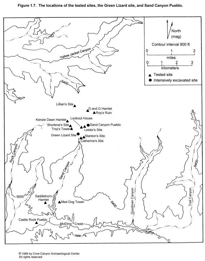
Roy's Ruin was recorded during the 1986 Crow Canyon Survey as CC86-53 (Van West et al. 1987) and was subsequently assigned site number 5MT3930. It was excavated in 1988 by Crow Canyon as part of the Sand Canyon Archaeological Project Site Testing Program. The site rests on a mesa top at 2076 m (6815 ft) and is 1 km (.6 mi) north-northeast of Sand Canyon Pueblo (Figure 1.7). A small tributary canyon of Yellow Jacket Canyon entrenches 100 m to the west of Roy's Ruin; a spring is located at the head of this tributary canyon. The bottom of Yellow Jacket Canyon lies 4 km (2.4 mi) north of Roy's Ruin.
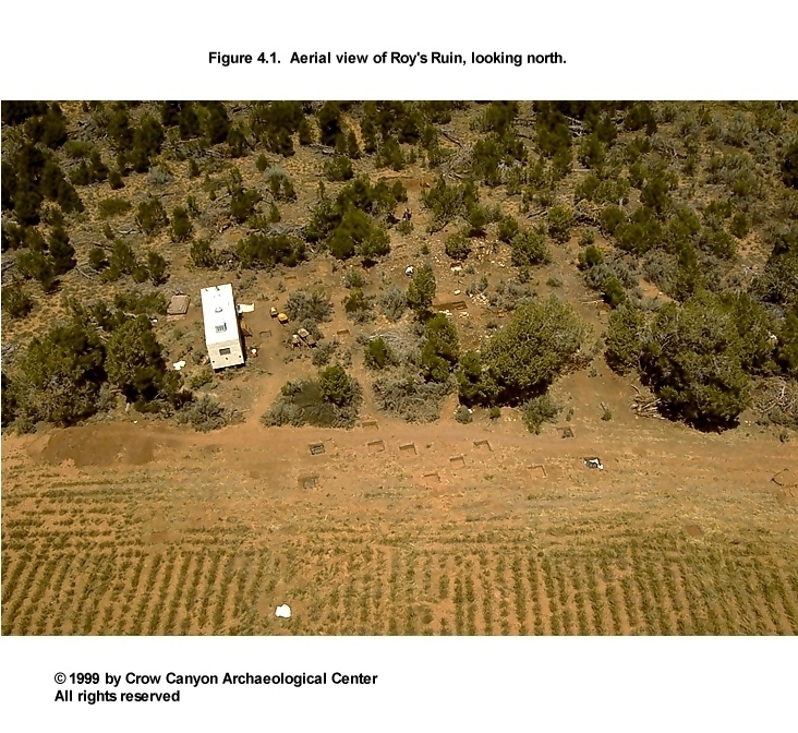
Pinyon-juniper woodland, dense sagebrush, and rabbitbrush cover the architectural units on the north half of the site. The pinyon-juniper woodland was chained in the 1960s. The midden on the south half of the site lies in an agricultural field. Today the field is out of production as a part of the crop withdrawal program (Figure 4.1 and Figure 4.2).
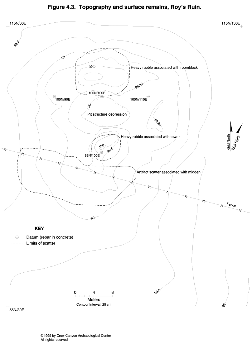
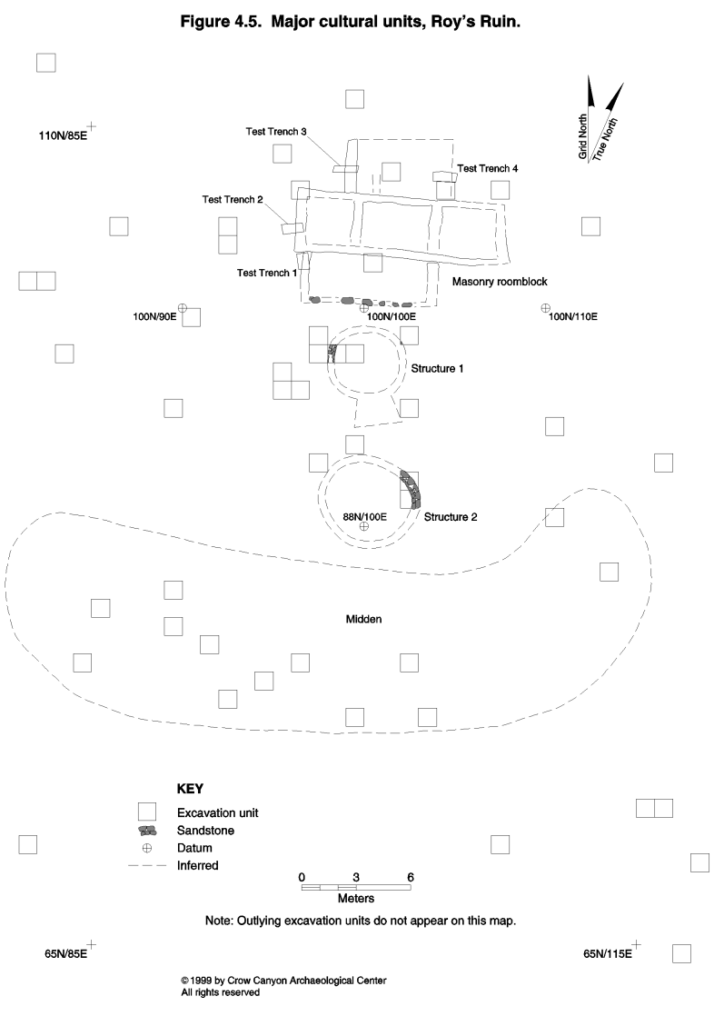
Surface remains at Roy's Ruin include a masonry rubble mound, a pit structure depression, a fallen masonry tower, and a midden (Figure 4.3). These cultural features are aligned, with the roomblock on the north end of the site, the pit structure immediately south of the roomblock, the tower just south of the pit structure depression, and the midden south of the tower. An inner periphery was defined on the east and west sides of the pit structure depression. The inner periphery is characterized by a slight topographic rise and a moderately dense artifact scatter (less dense than the midden, but of greater density than the remainder of the site). An area defined as the outer periphery surrounds the more clearly defined cultural units. The outer periphery was characterized by a light artifact scatter and no surface evidence of architecture or features.
These surface remains were used to define the sampling strata (provenienced as arbitrary units). Sampling Stratum 1 includes the masonry surface architecture associated with both the roomblock and the tower (Figure 4.4). Boundaries for Sampling Stratum 1 were drawn where the walls of the roomblock and tower were anticipated, not around the edges of the rubble scatters.
Sampling Stratum 2 is the pit structure depression. This depression is 32 cm deep, and 8 m in diameter. Sampling Stratum 3 is the area surrounding the pit structure depression, and bounded by the masonry roomblock, the tower, and the inner periphery. Sampling Stratum 3 is interpreted as a small courtyard adjacent to the architectural units.
Sampling Stratum 4 is the inner periphery. This area was defined on the basis of a low (25 cm) rise and abundant artifacts. The presence of features and nonmasonry architectural units was anticipated in the inner periphery.
Sampling Stratum 5 represents the midden (provenienced as Nonstructure 1). This midden is characterized by the highest density of surface artifacts on the site and sediments that are gray brown in contrast to the surrounding red brown sediments. Plowing had leveled any topographic rise that at one time might have been present and had dispersed the artifacts associated with the midden.
The outer periphery was divided into two sampling strata. Sampling Stratum 6 is the outer periphery at the southern end of the site surrounding the midden. The light artifact scatter that defines Sampling Stratum 6 had been dispersed by plowing. Sampling Stratum 7 is the outer periphery that surrounds the architectural units at the northern end of the site.
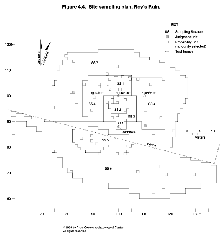
Within these sampling strata, excavation took place in 53 probability sampling units and two judgmentally located test pits (Figure 4.4). Figure 4.5 illustrates the location of the main cultural units discovered in these sampling units at Roy's Ruin. These features date to the Pueblo III period and include a masonry-lined kiva (Structure 1), a masonry roomblock, a masonry tower (Structure 2), and the midden (Nonstructure 1). These features indicate that Roy's Ruin was a habitation site probably occupied throughout the year.
The grid on Roy's Ruin was oriented along wall alignments in the roomblock. This grid is 23 degrees, 30 minutes west of magnetic north. Vertical Datum A is arbitrarily assigned an elevation of 100 m, and it is located on the top of the rebar at 88N/100E.
The following descriptions are organized by sampling stratum. Individual cultural units are discussed under the sampling stratum in which they were found.
Surface Architecture (Sampling Stratum 1)
Sampling Stratum 1 consists of the rubble mounds associated with the roomblock and the tower. The roomblock rubble is 60 cm high, and the tower rubble rises 85 cm high.
Ninety-six sampling units were present in Sampling Stratum 1, and six of these (89N/102E, 90N/102E, 106N/96E, 106N/104E, 102N/100E, and 107N/101E) were excavated (Figure 4.4). Two sampling units (89N/102E and 90N/102E) exposed portions of the tower, Structure 2. The remainder of the sampling units landed in rubble associated with the masonry roomblock but could not be assigned to specific rooms. Some sampling units appear to have landed just outside masonry rooms; other sampling units may be inside rooms, but the room boundaries could not be defined, given the limited excavations. In each of the sampling units, fill was removed in natural strata, and excavation was terminated when sterile sediments were reached.
Judgmentally located excavations were also undertaken to expose the layout of the roomblock (Figure 4.5). First, loose sediment was swept from the surface to expose wall alignments. This was followed by the excavation of four small trenches to locate walls in areas of the roomblock where they could not be followed by sweeping. Trench depth ranged between 10 and 20 cm.
Structure 2 (sampling units 89N/102E and 90N/102E) is described first, followed by discussions of the remainder of the Sampling Stratum 1 sampling units.
Structure 2
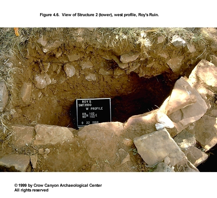
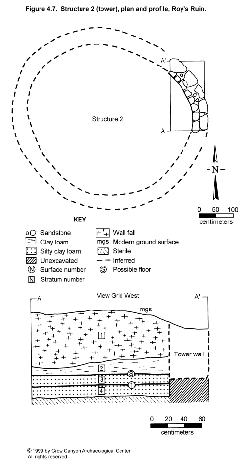
Structure 2 (Figure 4.6) is a circular masonry tower located south of the pit structure depression. The northeast corner of the tower was exposed by excavations. Dimensions are difficult to estimate given the limited testing, but the tower appears to be approximately 5.00 m in diameter (Figure 4.7).
Construction
Walls. The exposed wall of the tower was a maximum of 64 cm high and a minimum of 32 cm high. The sandstone block wall was fully coursed, with little chinking present; it measured 47 cm thick. The cross section was predominantly double-stone wide. In some places a rubble core was present, making the cross section double-stone with core; elsewhere, stones on the inside and outside of the wall overlapped so that the cross section was double-bonded. The mortar consisted of a brown silty clay loam with no apparent inclusions.
The outside face of the wall had been extensively pecked to produce a curved surface on the stones. Shaping on the inside of the wall was minimal. Large stones were used on the outside of the wall, and smaller stones on the inside of the wall.
No footing was present; instead, the wall was built on top of Stratum 4 (Figure 4.7). Stratum 4 resembles sterile B-horizon sediments in color and texture (brown to red brown silty clay loam), but it contains charcoal and caliche flecks. Stratum 4 is either a deposit that accumulated during an earlier occupation or a foundation stratum deliberately deposited prior to the construction of the tower walls. Because the stratum resembles sterile sediments, it may be sterile that was redeposited during the excavation of the pit structure, Structure 1.
Floor. The floor was difficult to define during excavation. Seen in profile, but not during excavation, was a diffuse stratigraphic break between Strata 2 and 3, just above the base of the tower walls (Figure 4.7). This diffuse break may represent a floor, but it does not appear to represent an intensively used surface. Alternatively, the Stratum 2-Stratum 3 boundary may simply mark two separate postabandonment depositional events.
A second, more abrupt, stratigraphic break occurs at the boundary between Strata 3 and 4, located just below the base of the tower walls. This break appears to be a use-compacted surface, and it was excavated as Surface 1. Two corrugated body sherds (PLs 1 and 2) were found lying horizontally on this surface. Three artifacts--a carbon-painted, black-on-white sherd (too small to identify to traditional type) and two flakes--were found in the fill 5 cm above this surface.
The two possible floors were separated by Stratum 3 (Figure 4.7). Stratum 3 is a red brown silty clay loam with numerous calcium carbonate inclusions and a few flecks of charcoal. Unburned adobe is present within Stratum 3. Stratum 3 was found inside the tower, but not outside.
Several possible explanations may account for this stratigraphy. First, the boundary between Strata 3 and 4 that occurs just below the tower walls may represent a surface that was used before the construction of the tower. If this is correct, the diffuse stratigraphic break between Strata 2 and 3 would be the only floor associated with the use of the tower.
Second, the surface between Strata 3 and 4 may represent the floor associated with the use of the tower. This interpretation seems most likely, as this surface could not be found outside of the tower. Stratum 3 could represent a remodeling event, or it could be material that was deposited when the tower was abandoned. If Stratum 3 is associated with abandonment of the tower, then the adobe in this stratum may have come from the dismantling of the tower roof. The upper diffuse stratigraphic break (between Strata 2 and 3) could be the result of natural postabandonment deposition, or it could represent a brief use of the tower after the roof had been dismantled.
Finally, Stratum 3 may be construction fill associated with the remodeling of the tower floor. The presence of this stratum only on the inside of the structure offers support for this interpretation.
Roof. The roof of Structure 2 did not burn, and there is little evidence to infer roof construction. Unburned adobe was recovered from Stratum 3, and in lesser amounts from Stratum 2. This adobe may have been part of the tower roof. No remains of rotting timbers were observed. It is possible that the tower roof was dismantled and the roof timbers salvaged when the structure was abandoned. It is likely that the Structure 2 roof was supported by the walls.
Dating
No absolute dates were obtained for Structure 2. The alignment of the tower with the other masonry architectural features on the site indicates that it is a part of the Pueblo III component at Roy's Ruin. This is supported by the presence of the carbon-painted sherd in the 5 cm of fill above the floor.
Stratigraphy
The stratigraphic profile is illustrated in Figure 4.7. Stratigraphy associated with the construction, use, and abandonment of the tower is complex. Strata 3 and 4 have been discussed above in the sections describing the tower walls and floor. The following discussion deals with the strata that are interpreted as being the result of postabandonment events.
Stratum 2 lies above the two possible floors in Structure 2. Stratum 2 is 18 cm thick and consists of red brown clay loam with virtually no inclusions, except for small pieces of unburned adobe. Stratum 2 accumulated after the tower had been abandoned but before the walls began to collapse; it may represent sediments from the tower roof. The remainder of the fill is Stratum 1, a deposit of wall fall 63 cm thick.
Structure 2 Interpretations
Structure 2 is a masonry tower associated with the Pueblo III occupation of Roy's Ruin. The tower is aligned with the other masonry architectural units on the site (the roomblock and the pit structure). Structure 2 function could not be determined, given the limited excavations.
The Masonry Roomblock
Four sampling units were excavated in the masonry roomblock (Figure 4.4). No specific rooms were identified within these sampling units. It is possible that some of the sampling units are within rooms, but that the room boundaries were not adequately defined during testing.
Sampling Unit 102N/100E
Construction. This 1-×-1-m sampling unit overlapped a sandstone block wall that ran along the north boundary of the grid square. The wall is semi- to fully coursed and appeared to be double-stone wide, but a clear view of the cross section was not obtained. Existing wall height is a maximum of 43 cm and a minimum of 32 cm; wall thickness is at least 30 cm, but additional excavation would be needed to better expose the wall cross section. Little shaping of the wall stones was observed. Mortar is a brown silty clay loam with no inclusions, which is the same type of material used for mortar in the tower walls.
This sampling unit may be inside a room, but the modern ground surface slopes down toward the south, and there is little evidence of a south wall on the modern ground surface. The fill of the pit structure (Structure 1) contained a great deal of sandstone rubble, and it may be that the south wall of a room fell or was deliberately deposited into the abandoned pit structure depression. Wall sweeping and trenching did locate portions of what might be the east and west walls of this room (Figure 4.5).
Stratigraphy. The wall exposed in 102N/100E rests on the top of Stratum 3, a 12-cm-thick layer of brown silty clay loam with flecks of charcoal and a few artifacts. Stratum 3 is interpreted as the A horizon present on Roy's Ruin prior to the construction of the masonry roomblock. The base of Stratum 3 contacts the sterile B horizon. The masonry roomblock does not appear to have been constructed on top of any earlier architecture, in contrast to the masonry roomblocks at G and G Hamlet, Lillian's Site, and Kenzie Dawn Hamlet.
Above Stratum 3 is Stratum 2, a 10-cm-thick stratum of brown silty clay loam. Stratum 2 differs from Stratum 3 in that it has more inclusions, including a few small pieces of sandstone, charcoal, and artifacts. The base of Stratum 2 is 2 cm below the base of the masonry wall, and the top of Stratum 2 is the base of the wall fall, Stratum 1. The base of Stratum 2 appears to have been the ground surface when the masonry roomblock was constructed. Stratum 2 appears to have been deposited during the use of the site, after the wall was constructed, but before the wall began to collapse. Stratum 1, which consists of postabandonment wall fall, is 34 cm thick next to the wall on the north edge of the sampling unit, and 11 cm thick on the south edge.
Feature 2 (Pit). A portion of a shallow pit feature was discovered at the contact between fill and the sterile B horizon in the west half of 102N/100E. The excavated portion of the feature measures 70 cm long, 50 cm wide, and 20 cm deep. Feature fill was similar to Stratum 3, a red brown silty clay loam, with charcoal flecks and sandstone. The feature fill is so similar to Stratum 3 that it is difficult to tell where the top of the feature is located. Apparently the feature filled before the roomblock was constructed. The feature contained two sherds, a Late White Unpainted bowl sherd and a corrugated jar sherd; the presence of these sherds indicates that the feature filled in either the Pueblo II or III periods.
Sampling Unit 106N/96E
A corner of the roomblock was found in 106N/96E. The sandstone block walls exposed by excavation are poorly preserved and stand only two courses (21 cm) high. These walls are double-stone wide in cross section and measure 30 cm thick. Wall fall, excavated as Stratum 1, lay atop the walls and continued down to the base of the standing wall.
The wall was constructed on top of Stratum 2, a 19-cm-thick layer of red brown silt loam. The base of Stratum 2 is the contact with the sterile B horizon. Stratum 2 contains no remains of earlier architectural units and probably represents the A horizon present before the construction of the masonry roomblock.
Sampling Unit 106N/104E
This sampling unit appears to be just north and east of the masonry rooms. This square was excavated in two strata down to the contact with sterile sediments. Stratum 1, the uppermost stratum, consisted of wall fall that ranged from 9 to 16 cm thick. Stratum 2, which ranged from 15 to 30 cm thick, was a red brown clay loam containing almost no inclusions. The Stratum 2 sediments popped off the stratigraphic contact with the sterile B horizon, and this contact appears to represent a cultural surface. A burned pit feature was found on this surface.
Feature 1 (Fire Pit). This is a shallow, circular pit feature filled with ash. Feature 1 measures 29 cm in diameter and 4 cm deep. The fill of the feature consisted of black, ashy sediments with charcoal inclusions; however, the walls of the pit were not oxidized. Feature 1 is therefore interpreted as a fire pit that had limited use. The temporal association of Feature 1 is uncertain, but the location of the pit at the contact of the sterile B horizon suggests that its use predates the construction of the masonry roomblock. One flake and three sherds (a Late White Unpainted jar sherd, a corrugated jar sherd, and a gray ware jar sherd) were found in the feature fill. The types of pottery recovered indicate that the feature filled in either the Pueblo II or Pueblo III periods.
Sampling Unit 107N/101E
This sampling unit is located on the north end of the rubble mound. It is not clear if this sampling unit is inside a back room or is located just north of the roomblock. Short segments of walls and the presence of rubble in this area may indicate the presence of a room, but walls that fully enclose a room could not be traced. This sampling unit was excavated in two strata down to the stratigraphic contact with the sterile B horizon. Stratum 1, the uppermost stratum, consisted of wall fall in a matrix of red brown silt loam; it was 20 to 28 cm thick. Stratum 2 was a 7- to 10-cm-thick stratum of red brown clay loam. A feature was discovered at the base of Stratum 2.
Feature 3 (Fire Pit). The easternmost half of a shallow, ash-filled pit was found in sampling unit 107N/101E. The exposed portion of the apparently circular pit measures 29 by 11 cm and is 5 cm deep. The pit was associated with a use surface located 3 cm above the contact with the sterile B horizon. Feature fill included ash, charcoal, and pieces of burned sandstone. This feature is interpreted as a fire pit. The temporal association of this fire pit is uncertain, but its location near the contact with the sterile B horizon suggests that its use predates the construction of the masonry roomblock.
Sampling Stratum 1 Summary and Interpretations
Sampling Stratum 1 includes a masonry roomblock and a masonry tower that date to the Pueblo III period. Six sampling units were excavated in Sampling Stratum 1--two in the tower (Structure 2) and four in the masonry roomblock rubble mound. The sampling units in the roomblock rubble mound exposed walls, but no rooms were positively identified. Sweeping and limited wall trenching were used to trace the walls beyond the limits of the 1-×-1-m sampling units and expose the layout of the roomblock: a single front room is probably present, three well-defined rooms lie in the central row of the roomblock, and a single back room may be present.
The masonry roomblock is built on a stratum of brown to red brown silt loam to silty clay loam. No evidence was found for architectural features beneath the masonry roomblock. The stratum beneath the masonry rooms may represent the A horizon present prior to the Pueblo III occupation of Roy's Ruin. Three pit features were found at or near the contact with the sterile B horizon, near the base of the stratum of fill on which the roomblock was constructed. The stratigraphic position of these pit features indicates that they may date to an occupation of Roy's Ruin that predates the construction of the masonry roomblock. Pottery from the fill of these features includes corrugated sherds that are either Pueblo II or Pueblo III pottery. The decorated sherds from the stratum below the base of the roomblock walls are all Late White Painted sherds with carbon paint. Thus, it is likely that the stratum beneath the roomblock dates to the late Pueblo II or early Pueblo III periods.
Pottery collected from all of the Sampling Stratum 1 excavations include 133 sherds (2.2 percent of the Roy's Ruin totals). The majority of these are corrugated (N = 67) and Late White Unpainted (N = 45), which could represent either Pueblo II or III pottery. Decorated white wares include 14 Late White Painted sherds with carbon paint decoration and a single Pueblo III White Painted sherd with carbon paint; the carbon paint indicates that all of these sherds probably date to the Pueblo III period. Decorated sherds from earlier occupations include a single Pueblo II White Painted sherd found in the stratum below the tower floor and an Abajo Red-on-orange sherd found in the upper portion of the rubble mound wall fall. Tools from Sampling Stratum 1 are one modified flake, one peckingstone, one other chipped-stone tool, and a fragment of bird bone that was ground and polished.
Pit Structure Area (Sampling Stratum 2)
Sampling Stratum 2 is the pit structure depression. The pit structure depression is shallow but more than 8 m in diameter. Forty-six sampling units were present in Sampling Stratum 2. Six probability sampling units (97N/97E, 97N/98E, 98N/97E, 98N/102E, 94N/102E, and 95N/96E) and one judgmentally located sampling unit (97N/99E) were excavated. One of the probability units and the one judgmental unit are located inside a masonry-lined pit structure, and these were provenienced as Structure 1. The remainder of the probability sampling units are located around the edges of Structure 1.
In the following discussion, Structure 1 is described first, followed by the description of the remainder of the Sampling Stratum 1 excavation units.
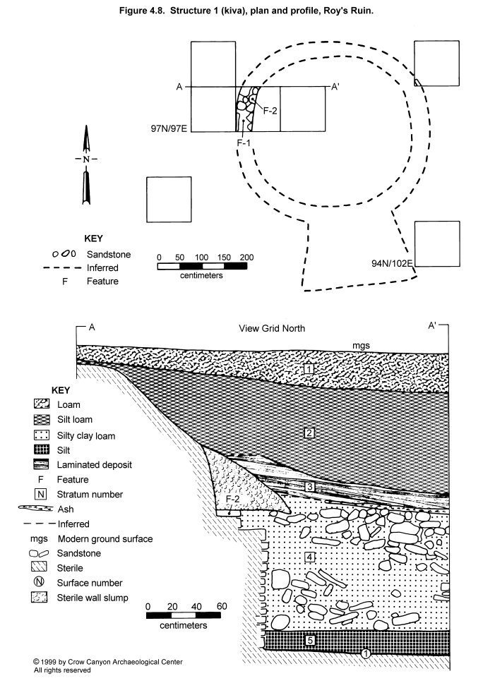
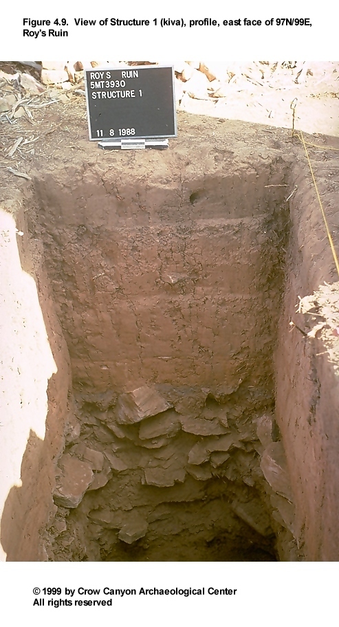
Structure 1
Structure 1 is a masonry-lined kiva associated with the Pueblo III occupation of Roy's Ruin (Figure 4.8 and Figure 4.9). Most Sampling Stratum 2 units did not land inside the pit structure, but they did help determine the size of Structure 1, and they provided an explanation for why the pit structure depression was so large. The large depression was found to be the result of the slumping of the earth walls above the masonry lining of the pit structure. There was no evidence of superimposed pit structures from earlier occupations or of the complex kiva architecture found at Sand Canyon Pueblo, where corner rooms are attached to the main chamber of the kiva.
Sampling units inside Structure 1 reveal a circular structure; the diameter from bench face to bench face is approximately 3.50 m, and the diameter above the bench is approximately 4.30 m. Depth from the courtyard surface associated with the construction of Structure 1 to the main chamber floor is 2.30 m.
Construction
Walls. The exposed portion of Structure 1 has masonry lower and upper lining walls. The bench face measures 16 cm wide and 87 cm high and is one stone deep. This wall is fully coursed and constructed on top of sterile sediments. Both blocky and tabular pieces of sandstone were used; shaping is limited to a minimal amount of flaking and pecking. Mortar joints are .5 to 1 cm thick, chinking is absent, and the mortar is a brown to red brown silty clay loam with calcium carbonate inclusions. Small portions of three coats of plaster cover a small segment of the wall.
The visible upper lining wall construction consists of an upright slab with horizontally coursed masonry set in mortar on top of this slab. The wall is 50 cm high. The top of the upper lining wall is a maximum of 12 cm thick and is 85 cm below the prehistoric ground surface. Two features, a bench and a collapsed pilaster, are associated with the Structure 1 walls.
Feature 1 (Bench): A portion of the main chamber bench was exposed in 97N/98E, and this was provenienced as Feature 1. The bench surface consists partly of adobe plaster and partly of the tops of the stones of the main chamber lining wall. A single piece of chipped-stone debris was the only artifact found on the bench surface. The bench measured 39 cm wide, and the portion exposed in 97N/98E was 54 cm long. This bench is bounded on the north by a collapsed pilaster, Feature 2.
Feature 2 (Pilaster): A portion of a collapsed pilaster was also found in 97N/98E. The pilaster was constructed on top of the bench surface. The pilaster is only partly preserved, measuring 66 cm long, 42 cm wide, and 22 cm high. The pilaster was constructed with pecked-block masonry that stands a maximum of three courses high. There is no pit structure upper lining wall behind the pilaster; it appears that the pilaster was constructed first and the upper lining wall abutted the pilaster. It is not clear whether the pilaster collapsed naturally or was destroyed as a part of the abandonment of Structure 1. A red water-worn pebble was found in the center of the pilaster at the level where the pilaster was first discovered. The pebble was in mortar-like sediments, but because the pilaster was poorly preserved, it was not clear if the pebble had been incorporated into the pilaster during construction or was associated with the fill that covered the collapsed pilaster (this artifact was point-located at the base of the stratum that covered the pilaster).
Floor. The floor was constructed with adobe placed on top of undisturbed sterile. A single corrugated sherd was the only floor-contact artifact. A patch of ash was also found on the floor. Flotation samples analyzed from the kiva contained a rare Cycloloma atriplicifolium seed, and sagebrush, juniper, cottonwood/willow, and bitterbrush/cliffrose wood charcoal (see Chapter 16). A complete turkey bone was found 3 cm above the floor contact. Two burned modified bone fragments, (one is a worked bobcat ulna) were also found in the fill 5 cm above the floor. Two pollen samples collected from the floor were analyzed (see Chapter 17). Economic pollen identified in these samples includes beeweed and maize.
Roof. The Structure 1 roof was supported by pilasters, one of which was exposed by excavation. In the Mesa Verde region, pit structures usually have six-pilaster roof-support systems, and this is probably the case for Structure 1.
No Structure 1 roof timbers were found; they may have been salvaged at the time of structure abandonment. Large pieces of unburned adobe lay directly on the floor, evidence that at least portions of the roof collapsed at the time of abandonment. Dismantling the roof could have resulted in the deposition of the adobe on the floor and perhaps the destruction of the pilaster, Feature 2, as well. Both stone and roof timbers may have been salvaged at the time of abandonment. Stratigraphy associated with the abandonment of Structure 1 is presented in greater detail below.
Dating
Forty tree-ring samples were collected from the fill of Structure 1, and 21 of these produced dates. All of the dated samples are juniper. Results of the analysis of these specimens are presented in Table 4.1.
Interpretation of these dates is difficult because the origin of the wood is unclear. The situation is similar to that at Lillian's Site (see Chapter 3, the discussion of Structure 1 dating). Tree-ring samples were found throughout Strata 4 and 5 (Figure 4.8), from 1 cm to 1 m above the floor. These tree-ring samples are too small and fragmentary to be the main roof beams, but the samples are larger than charcoal from hearths, and they were not associated with ash deposits. Thus, the charcoal collected for tree-ring dating is interpreted as fragments of structural wood, probably smaller roofing materials, and not as fuel refuse from hearths.
Both Strata 4 and 5 (Figure 4.8) are interpreted as cultural deposits that accumulated shortly after Structure 1 abandonment. There is no clear patterning between the dates and the locations of the samples; both early and late dates occur in the fill immediately above the floor and at the top of Stratum 4, 1 m above the floor.
The only indication that this structure burned is patches of ash on the floor. The adobe floor did not appear to be oxidized beneath the ash, and it is not clear if the ash represents an in-place burn or was refuse thrown onto the floor.
The dates for Structure 1 range between A.D. 992 vv and 1223 vv. Cutting dates and dates that can be interpreted as cutting dates include a 1213 v and 1213 r. Dates associated with the floor and with the fill within 5 cm of the floor include A.D. 992 vv, 1138 ++vv, 1197 vv, and 1212 vv. Thus, the tree-ring dates for Structure 1 indicate that the structure was occupied in the early A.D. 1200s, probably after A.D. 1223.
The pottery in the fill 5 cm above the floor supports this dating interpretation. Decorated sherds include a Mesa Verde Black-on-white sherd and four carbon-painted Pueblo III White Painted sherds.
Stratigraphy
Figure 4.8 illustrates the stratigraphic profile of Structure 1. Figure 4.9 shows the stratigraphic profile of the east face of sampling unit 97N/99E. Not shown on the profile (Figure 4.8) are the thin (1 cm) patches of ash found on the floor.
Stratum 5 covers the adobe floor and the thin patches of ash on the floor. Stratum 5 is a level, 20 cm thick deposit of brown to gray brown silt. The color may be due to the presence of ash mixed in with the sediment, but no pockets of pure ash were observed. The primary inclusion in Stratum 5 is adobe, mostly unburned, but some burned adobe with vegetal impressions is also present. Other inclusions in Stratum 5 include numerous artifacts, charcoal pieces large enough to be collected as tree-ring samples, small (less than 10 cm) pieces of sandstone, and flecks of calcium carbonate. A bone awl and an axe are complete tools that were found against the west wall in Stratum 5, 15 to 20 cm above the floor.
Stratum 5 is interpreted as culturally deposited fill. The abundant adobe in Stratum 5 may have come from the roof, which was apparently dismantled to salvage timbers. The ash on the floor and the charcoal in Stratum 5 may have resulted from the burning of the smaller closing material in the roof, or they may represent trash thrown into Structure 1 immediately after it was abandoned. The fact that the stratum is level indicates that the roof was not intact. If material was being deposited through the roof entry we would expect a stratum mounded toward the center of the structure. If material was washing, blowing, or collapsing into Structure 1 from the edges of the structure we would expect a basin-shaped stratum. There was no evidence of sorting by particle size within Stratum 5. This sorting occurs in both wind and water deposition, and therefore the Stratum 5 sediment does not appear to have been transported by these natural processes. Finally, transport and deposition by wind, water, or gravity would alter (erode) the inclusions found in Stratum 5. The inclusions in Stratum 5, however, had angular edges, and the adobe was preserved well enough to allow recognition of vegetal impressions. This indicates that the inclusions were transported into Structure 1 quickly and from a short distance, and that they were quickly covered, so that little erosion took place.
A relatively large number of artifacts in Stratum 5 also suggests cultural deposition. Tools include a complete single-bitted axe, a mano fragment, a bone awl fragment, a ground and polished bird bone, and three modified sherds. Stratum 5 also includes 129 sherds and 25 pieces of chipped-stone debris. Pottery includes McElmo Black-on-white (N = 1), Pueblo III White Painted (N = 10), Late White Painted (N = 10), Late White Unpainted (N = 41), Mancos Corrugated (N = 1) and Indeterminate Local Corrugated Gray body sherds (N = 65). It is not clear if these items had been incorporated into roof construction sediments, were on or in the roof when it was dismantled, or were refuse from somewhere else that was thrown into the structure as the roof was being dismantled.
Stratum 4 is a massive deposit, 1 m thick, characterized by the presence of sandstone building stone. The sandstone removed from Stratum 4 measured .79 m³. It lay in a matrix of brown to dark brown silt to silty clay loam. Charcoal, burned and unburned adobe, and calcium carbonate flecks are also inclusions in Stratum 4. There was no evidence of lenses sorted by particle size within Stratum 4. The upper boundary of Stratum 4 is an ash lens 4 cm thick.
Stratum 4 might be composed of naturally (gravity) deposited materials from a collapsed room located on the edge of Structure 1. This, however, seems unlikely. First, the stones in Stratum 4 lay in a jumbled mass, one on top of another, which suggests rapid deposition. Second, the deposition of Stratum 4 appears to have begun shortly after Structure 1 was abandoned (the dense concentration of stones begins just 20 cm above the Structure 1 floor). Finally, the ash lens that caps the stones in Stratum 4 appears to be a trash deposit, not the result of a natural depositional event. A number of taxa were identified in flotation samples (one of which was collected from this ash lens) and interpreted as both fuel and food remains (see Chapter 16). This may indicate that parts of the site were still occupied after Structure 1 was abandoned.
The natural deterioration of a masonry room would be a gradual process, beginning years after the room was abandoned and continuing over many more years. Gradual deposition would result in a mixing of sediments from other types of depositional events (for example, wind and water deposition). Stratum 4, however, shows no signs of such mixing but, rather, appears to be a deposit that accumulated rapidly shortly after Structure 1 was abandoned. This stratum, therefore, is interpreted as a deposit of secondary refuse thrown into Structure 1.
A complete bone awl, a modified flake, and a piece of pecked sandstone were the tools found in this stratum. Ninety-nine sherds were found in Stratum 4: Indeterminate Local Corrugated Gray (N = 48), Pueblo III White Painted (N = 5), Late White Painted (N = 7), and Late White Unpainted (N = 39). Fourteen pieces of chipped-stone debris were also found in this stratum.
Stratum 3, 20 cm thick, is a strong brown silty clay loam characterized by faint laminations sorted by particle size (coarse material on the bottom and fine material on the top). Inclusions are virtually absent, but some charcoal flecks do occur. Stratum 3 is interpreted as water-deposited sediment.
Stratum 2 is 80 cm thick and consists of a dark yellow brown silt loam. Charcoal flecks are abundant, and a few small (less than 10 cm) pieces of sandstone are present as well. Stratum 2 was homogeneous from top to bottom in terms of color and particle size; the processes responsible for the formation of Stratum 2 are not known for certain, but the sediments probably accumulated naturally. A nearly complete McElmo Black-on-white dipper was found in the lower portion of Stratum 2. The broken handle of the dipper had been ground.
Stratum 1 is a dark brown loam to silt loam, essentially the modern A horizon. Inclusions are virtually absent. Stratum 1 is interpreted as a naturally deposited stratum.
The upper, naturally deposited fill (Strata 1, 2, and 3) of Structure 1 contained few artifacts. A peckingstone and the dipper mentioned above were the only tools. There were 37 sherds and 11 pieces of chipped-stone debris in addition to these tools.
Structure 1 Interpretations
Structure 1 is a masonry-lined pit structure; this is the type of structure traditionally interpreted as a Mesa Verde-style kiva. However, excavation in Structure 1 was too limited to determine how the structure was used. Structure 1 lacks the complex architecture (a square enclosing structure and corner rooms) associated with Sand Canyon Pueblo kivas (Bradley 1993, 1992b). The architectural differences may indicate that Structure 1 is less specialized for ritual activity than are the Sand Canyon Pueblo kivas.
Stratigraphic evidence suggests that the Structure 1 roof may have been dismantled at abandonment and that the structure was partly filled as well. This same type of abandonment has been inferred for the pit structures at Lillian's Site and Shorlene's Site.
Tree-ring dates from charcoal in the cultural deposits above the Structure 1 floor indicate that this structure was occupied in the early A.D. 1200s, with the occupation lasting until sometime after A.D. 1223. The presence of Mesa Verde Black-on-white pottery in the fill 5 cm above the floor supports this interpretation.
Sampling Stratum 2 Sampling Units Outside Structure 1
Five randomly located sampling units fell just outside of Structure 1 (97N/97E, 98N/97E, 98N/102E, 94N/102E, and 95N/96E). The three sampling units that landed closest to Structure 1 (97N/97E, 98N/102E, and 94N/102E) all displayed evidence of being adjacent to the pit structure: the sterile sediments had dropped down on the side of each sampling unit adjacent to the structure. This occurred along the east edge of 97N/97E, where excavation stopped when the masonry upper lining wall was found along the 97E grid line, 92 cm below the modern ground surface. The stratigraphic contact with sterile sediments sloped down in the southwest corner of 98N/102E, and a horizontal stone believed to be the top of the masonry upper lining wall was found 1.10 m below the modern ground surface directly below grid point 98N/102E. The sterile sediment also sloped down in the northwest corner of 94N/102E, but a masonry wall was not found in this sampling unit. Therefore we excavated this corner of the sampling unit as a pit feature, Feature 1 of Sampling Stratum 2. These areas are interpreted as places where the sterile sediment eroded into Structure 1 after it was abandoned and the roof was removed.
The two remaining sampling units in Sampling Stratum 2 were excavated to the contact with sterile sediments. Both sampling units were approximately 20 cm deep. Few artifacts were found in the Sampling Stratum 2 sampling units that lie outside Structure 1; only 81 sherds and four stone tools were recovered.
Courtyard Area (Sampling Stratum 3)
Sampling Stratum 3 was defined to encompass the courtyard surrounding Structure 1 (Figure 4.4). This courtyard, provenienced as Nonstructure 2, is bounded on the north by the masonry roomblock, on the south by the tower, and on the east and west by a slight topographic rise that may contain nonmasonry architectural units. Eighty sampling units are present in Sampling Stratum 3; four of these (92N/99E, 95N/95E, 96N/95E, and 91N/97E) were excavated (Figure 4.4).
Each sampling unit was excavated in natural strata down to sterile sediments. No architectural units or features were found. No surfaces were defined, except for the contact between the strata containing cultural material and the underlying sterile B horizon.
Two sampling units, 92N/99E and 91N/97E, were excavated near, but outside, the tower (Structure 2). Wall fall from the tower was found in both units. The other two sampling units, 95N/95E and 96N/95E, are located west of the pit structure, Structure 1. The top of the sterile B horizon in the four sampling units ranges from 99.06 m elevation in 91N/97E to 98.94 m elevation in 96N/95E. A corner-notched projectile point with a serrated edge was found 5 cm below the modern ground surface (99.15 m elevation) in 96N/95E. The projectile point is small (26 mm long, 18 mm wide, 5.5 mm thick), a characteristic of Puebloan projectile points, but the reduction technology most closely resembles Late Archaic-style points. The tip had been broken by an impact fracture, and subsequent battering had further blunted the tip (Bruce Bradley, personal communication 1989).
Artifacts recovered from Sampling Stratum 3 include 98 sherds, four stone tools, and 54 pieces of chipped-stone debris. Half of the sherds were found in sampling unit 91N/97E.
Inner Periphery (Sampling Stratum 4)
Sampling Stratum 4 is the inner periphery sampling stratum (Figure 4.4), which is characterized by a slight topographic rise and moderate artifact density. Three hundred sixty-five sampling units are present in Sampling Stratum 4. Nine probability sampling units (106N/107E, 104N/112E, 104N/86E, 104N/92E, 103N/92E, 99N/90E, 95N/89E, 93N/110E, and 91N/116E) and one judgmentally selected sampling unit (88N/110E) were excavated. Each sampling unit was excavated in natural strata down to the contact with sterile sediments.
Sampling Unit 104N/86E
Located 10 m west of the roomblock, this unit was excavated in two strata. Stratum 1 was a 20-cm-thick deposit of brown silt loam, which is the modern A horizon. A Pueblo III-style, side-notched projectile point was found 13 cm below the modern ground surface in Stratum 1. Stratum 2 was a 7- to 12-cm-thick red brown silty clay loam that was a transition between the A horizon and the sterile B horizon.
Sampling Units 104N/92E and 103N/92E
These two contiguous sampling units are located 4 m west of the masonry roomblock. Stratum 1 in these units consists of a brown, loamy A horizon, 8 cm thick. Stratum 2 is an 18- to 20-cm-thick deposit of gray brown sandy loam with charcoal, adobe, and small- to medium-size pieces of sandstone (small = less than 5 cm; medium = 5-10 cm). Stratum 3 is an 8-cm-thick stratum of red brown clay loam, heavily mottled with flecks of calcium carbonate. Stratum 3 rests on top of the sterile B horizon.
The boundary between Strata 2 and 3 was abrupt and smooth and may be an extramural surface or a floor inside a room. There is not sufficient rubble to indicate a masonry room, but the adobe and small sandstone in Stratum 2 may be the result of the collapse of a nonmasonry structure. Stratum 3 may be construction fill associated with the floor of a room. Walls were not identified, and additional excavation would be needed to conclusively determine if there is a room in this area.
Feature 2 (Pit)
A shallow pit feature was discovered in 104N/92E at the contact with sterile sediments. This circular pit measured 40 cm in diameter and was 9 cm deep. It was filled with light brown sandy loam. The location of this feature at the contact with the sterile B horizon, 60 cm below the modern ground surface, suggests that it may have been used and abandoned before the Pueblo III occupation of Roy's Ruin.
Sampling Unit 99N/90E
This sampling unit was excavated to a depth of about 58 cm. Stratum 1 consists of an upper 4 cm of brown loam (the modern A horizon) and below that a 16- to 18-cm-thick deposit of mottled brown to gray brown silt loam with charcoal, adobe, and small pieces of sandstone. A 6-cm-thick ash lens was found at the base of Stratum 1 in the northwest corner of the sampling unit. This may be a hearth, but the sediments at the base of the ash lens did not appear to be burned, so it is also possible that it is secondary refuse. Stratum 2, 16 cm thick, is a red brown silty clay loam with charcoal and calcium carbonate flecks. Stratum 3 is a 12-cm-thick deposit of brown silt loam with fewer charcoal and calcium carbonate flecks than Stratum 2. A discontinuous, 1- to 3-cm-thick lens of red brown silty clay loam with flecks of calcium carbonate was found at the boundary between Strata 2 and 3. This lens may be a cultural surface. The sterile B horizon lay beneath Stratum 3.
Heavy rodent disturbance makes the interpretation of this unit difficult. The boundary between Strata 1 and 2 was clear and smooth and could be either an extramural surface or a use-compacted surface inside a nonmasonry room. The discontinuous lens found at the boundary between Strata 2 and 3 also could be a prepared extramural surface or a room floor. Additional excavation that exposed a larger horizontal area would be needed to favor one interpretation over another.
A rodent-disturbed pit feature was found at the contact with the sterile B horizon. This feature measured 33 cm in diameter and was 14 cm deep; it was filled with a brown loam mottled with charcoal and adobe flecks. The location of this feature at the base of this sampling unit suggests that it was used and abandoned before the Pueblo III occupation of the site.
Sampling Unit 95N/89E
This sampling unit is located 8 m west of Structure 1, the masonry-lined pit structure. Stratigraphy in this sampling unit was similar to the stratigraphy in 104N/86E. Stratum 1 was a brown silt loam A horizon. Stratum 2 was a red brown silty clay loam that was a transition between the A horizon and the sterile B horizon. Stratum 2 contained charcoal flecks and a few artifacts, one of which was a projectile point fragment. The contact with sterile was found 36 cm below the modern ground surface.
Sampling Unit 106N/107E
This sampling unit is located approximately 3 m east of the northeast corner of the masonry roomblock. Two strata were excavated: a brown silt loam with wall fall (31 cm thick) and a red brown silty clay loam (12 cm thick).
Sampling Unit 104N/112E
This sampling unit is located 8 m east of the masonry roomblock. A single stratum of brown silt loam, 23 to 32 cm thick, was excavated down to sterile sediments.
Sampling Unit 93N/110E
This sampling unit is located 9 m east of Structure 1. It was excavated in two strata down to the contact with sterile sediments. Stratum 1 was a brown to gray brown silt loam, 20 cm thick. Stratum 2 was a brown silt loam as well, but heavily mottled with inclusions of charcoal, calcium carbonate, and small pieces of sandstone.
Sampling Unit 91N/116E
This is the last of the probability sampling units excavated in Sampling Stratum 4; it is located in the southeast corner of this sampling stratum. The area surrounding this unit displayed a noticeable topographic rise, but there were also signs of heavy disturbance. Fallen trees and numerous depressions were present nearby. It was not clear if the depressions were the result of chaining that toppled the trees, or if the depressions were pot hunters' excavations.
This sampling unit was excavated in two strata. Stratum 1 was a 40- to 46-cm-thick layer of brown loam with abundant medium-size (between 10 and 20 cm) sandstone present, especially toward the bottom of the stratum. Stratum 2, 2 to 6 cm thick, was the same brown loam but was mixed with red brown silty clay loam similar to the sterile B horizon. The source of this mixing is not known.
Sampling Unit 88N/110E
This square was laid out in the wrong location and therefore is not included in the probability sample. Stratum 1, 40 cm thick, was a brown loam excavated down to the contact with the sterile B horizon. Artifact density in this stratum was similar to artifact densities in the midden (Nonstructure 1, Sampling Stratum 5), located 5 m to the southwest.
Inner Periphery Artifacts
A total of 2,169 sherds were recovered from Sampling Stratum 4. The decorated white wares that could be categorized to traditional type include Mancos Black-on-white (N = 5), McElmo Black-on-white (N = 3), and Mesa Verde Black-on-white (N = 26). Another 87 sherds were classified as Pueblo III White Painted, a category of carbon-painted sherds that are either McElmo or Mesa Verde black-on-white, but which cannot be categorized specifically to traditional type. Another 195 sherds were more generically categorized as Late White Painted; 184 of these have carbon paint, which indicates that most are Pueblo III pottery. A single mineral-painted sherd from Sampling Stratum 4 was typed Pueblo II White Painted, indicating that it is either Cortez or Mancos black-on-white.
Tools and tool fragments recovered from Sampling Stratum 4 include three manos, one abrader, two peckingstones, three projectile points (one complete and two broken), one biface, two drills, one other chipped-stone tool, 18 cores, 10 modified flakes, eight modified sherds, and two pieces of modified bone. In addition to these tools, 838 pieces of chipped-stone debris were also recovered from Sampling Stratum 4. The Sampling Stratum 4 artifact density is only slightly less than the artifact density in the midden, Sampling Stratum 5.
Inner Periphery Summary and Interpretations
Sampling Stratum 4, the inner periphery, is located on the east and west sides of the masonry architectural units at Roy's Ruin; it is characterized by a slight topographic rise and moderate artifact density. Nonmasonry architectural units, extramural surfaces, and features were anticipated in this area. Possible surfaces were encountered in 104N/92E, 103N/92E, and 99N/90E, but additional excavation would be needed to determine if these surfaces are associated with rooms or with extramural surfaces.
Features discovered at the base of two units may indicate that there was an earlier (pre-Pueblo III) occupation of Roy's Ruin. Artifact density was especially high in 91N/116E and 88N/110E; further excavation would also be needed in these areas to better interpret these higher artifact densities.
The fact that the majority of the decorated sherds are Pueblo III pottery means that the majority of the other artifacts in Sampling Stratum 4 were deposited during the Pueblo III period as well. The presence of a small amount of earlier pottery, predominately Pueblo II pottery, suggests that there was an earlier limited-use occupation at Roy's Ruin.
The excavated units in Sampling Stratum 4 had deeper, stratigraphically more complex deposits than did excavated units in the courtyard (Sampling Stratum 3) and outer periphery (Sampling Strata 6 and 7). There are similar areas of deeper deposition that bound the courtyard and architectural units at most of the mesa-top unit pueblos. These appear as low berms on the surface. Several ethnoarchaeological studies of refuse disposal (Arnold 1990:918; Deal 1985:262; Hayden and Cannon 1983:126) document the presence of "toft" areas that form around the edges of courtyards and patios. Toft areas are created when refuse accumulates as a result of sweeping and other regular maintenance activities aimed at keeping the courtyard free of refuse. The inner periphery at Roy's Ruin may have formed in this manner as well. Whatever the depositional processes, these berms appear on several mesa-top sites, indicating that they may be a distinct type of feature. More excavation would be needed to clarify the depositional processes that produce these berms.
Midden (Sampling Stratum 5)
Sampling Stratum 5 is the Roy's Ruin midden, provenienced as Nonstructure 1. The midden, recognized on the basis of surface remains, lies in a fallow alfalfa field south of the architectural units (Figure 4.5). Plowing has dispersed the artifacts and leveled whatever mound may have once existed. Surface indications used to draw the boundaries of Sampling Stratum 5 include a heavy concentration of artifacts and soil that was more gray brown than the surrounding red brown sediments. Subsurface testing indicates that the midden in fact extends further east than the boundaries that were defined for Sampling Stratum 5 (compare Figure 4.4 and Figure 4.5), but boundaries of the original midden remain unclear due to the plowing.
Two hundred and one sampling units are present in Sampling Stratum 5; ten (84N/89E, 83N/85E, 82N/89E, 81N/91E, 80N/96E, 80N/102E, 80N/84E, 79N/94E, 78N/92E, and 77N/99E) were excavated (Figure 4.4). Each sampling unit was excavated down to sterile sediments.
A single stratum of secondary refuse was present in Nonstructure 1. Sediments consisted of a brown to gray brown silt loam with no developed structure. Flecks of charcoal and calcium carbonate and small- to medium-size (less than 10 cm) pieces of sandstone were abundant. This stratum ranged from 27 cm thick on the edge of the midden to 42 cm thick in the center. Two features were encountered in Nonstructure 1.
Feature 1 (Pit)
Feature 1 is a circular pit feature located in 80N/96E. Feature 1 measured 40 cm in diameter and 20 deep. Fill inside the pit was the same as Stratum 1 in the midden. The use of Feature 1 is not known. Pottery in the fill of this feature includes a Pueblo III White Painted sherd, indicating that the pit probably filled during the Pueblo III occupation of the site.
Feature 2 (Burial 1)
Feature 2, Burial 1, is located in 77N/99E. The body was that of a juvenile placed in a shallow pit. The burial pit measured 70 cm long by 65 cm wide by 19 cm deep.
The skeleton was incomplete, and the bones present were scattered inside the pit. The incompleteness of the skeleton and the fact that the bones were disarticulated may indicate that Feature 2 is a secondary interment. Alternatively, the burial may have been disturbed more recently; several bones were broken, possibly the result of plowing.
No offerings accompanied Burial 1. Artifacts in the burial pit are believed to be refuse from the midden that was used to cover the interment; the associated refuse therefore predates the burial event and provides the earliest possible date that the interment could have taken place. Pottery in the burial pit includes a Mesa Verde Black-on-white sherd, indicating that the individual was interred after A.D. 1180 (cf. Wilson [1991] for the dating of Mesa Verde Black-on-white) and was probably associated with the main occupation of Roy's Ruin, which dates to the early A.D. 1200s.
Midden Artifacts
Decorated white wares from the midden that predate the main occupation of Roy's Ruin include Early White Painted (N = 1), Pueblo II White Painted (N = 3), Late White Painted with mineral paint (N = 23), and Mancos Black-on-white (N = 7). Pottery that dates to the Pueblo III occupation includes Late White Painted with carbon paint (N = 296), Pueblo III White Painted (N = 120), McElmo Black-on-white (N = 9), and Mesa Verde Black-on-white (N = 28).
Complete and fragmentary tools recovered from the midden include two metates, four manos, three abraders, five peckingstones, 14 cores, one biface, one drill, four other chipped-stone tools, two pieces of modified bone, eight modified sherds, and eight modified flakes. In addition, 1,067 pieces of chipped-stone debris were recovered.
Eight flotation samples from the midden were analyzed (see Chapter 16). Juniper, pine, cottonwood/willow, and sagebrush charcoal were identified. Corn cupules were also found and are believed to indicate the use of corncobs as fuel. Cheno-am and Physalis longifolia seeds and one charred bean were also recovered from the midden.
Midden Summary and Interpretations
The midden at Roy's Ruin is interpreted as a location where secondary refuse was deposited. The location of the midden to the south of the architectural units is a characteristic of each of the mesa-top unit pueblos. The midden lies in an agricultural field, and its boundaries have been diffused by plowing. Plowing has also reduced the depth of the midden deposits.
The predominance of Pueblo III decorated pottery in the midden suggests that the vast majority of other artifacts recovered from the midden were also deposited during the Pueblo III occupation of the site, which is dated to the early A.D. 1200s. A small amount of material may date to an earlier, limited use of the site.
South Outer Periphery (Sampling Stratum 6)
Sampling Stratum 6 is the outer periphery sampling stratum surrounding the midden on the south end of the site (Figure 4.4). Sampling Stratum 6 contains 1,154 sampling units, 11 of which were excavated (85/113E, 78N/74E, 77N/103E, 72N/115E, 72N/116E, 70N/107E, 70N/81E, 69N/118E, 69N/129E, 64N/117E, and 61N/113E). All sampling units except 85N/113E are located in the plowed field at the south end of the site.
A single stratum of brown silt loam was excavated down to sterile sediments in each of the Sampling Stratum 6 units. The thickness of these deposits varies from 17 cm in 78N/74E (on the west edge of Sampling Stratum 6) to 38 cm in 77N/103E (in the center of Sampling Stratum 6, adjacent to the midden).
Artifact density was low in all but two of the sampling units, 77N/103E and 85N/113E. These two sampling units had artifact densities comparable to those in sampling units excavated in the midden. Of the 363 sherds found in this sampling stratum, 280 were found in these two sampling units. Six stone tools and 105 pieces of chipped-stone debris were also recovered from Sampling Stratum 6 excavations. There were no features and no architectural units discovered in Sampling Stratum 6.
North Outer Periphery (Sampling Stratum 7)
Sampling Stratum 7 is the outer periphery sampling stratum surrounding the architectural units at the north end of the site. Sampling Stratum 7 contains 764 sampling units. Seven probabilistic sampling units (113N/82E, 108N/95E, 111N/99E, 101N/81E, 97N/83E, 95N/74E, and 86N/121E) were excavated (Figure 4.4). Excavation was begun on one judgmentally located sampling unit (101N/82E), but it was not completed.
A single stratum of brown silt loam was present above the sterile B horizon in all but one of the probability sampling units. In 108N/95E, two strata were excavated: Stratum 1, which contained wall fall, and Stratum 2, which began at the base of the wall fall and continued down to the contact with sterile sediments. The Sampling Stratum 7 deposits range in thickness from 12 to 20 cm. The edge of what appeared to be a pit feature was found in 101N/81E, and 101N/82E was excavated to further expose the possible feature. A layer of horizontal sandstone slabs that appeared to be the top of the feature was uncovered in 101N/82E; however, time constraints did not permit excavation.
A total of 178 sherds and 71 pieces of chipped-stone debris was recovered from Sampling Stratum 7 excavations. Tools found in Sampling Stratum 7 include a shaped sherd and two other chipped-stone tools.
Roy's Ruin Artifacts
Artifact data are summarized in tables at the end of this chapter (Table 4.2, Table 4.3, Table 4.4, Table 4.5, and Table 4.6). Table 4.2 presents a summary of the pottery recovered from Roy's Ruin. Decorated white and red ware types found at Roy's Ruin that predate the Pueblo III period and provide evidence for an earlier occupation include Early White Painted (N = 2), Pueblo II White Painted (N = 5), Mancos Black-on-white (N = 12), Abajo Red-on-orange (N = 2), and Bluff Black-on-red (N = 1). In addition, sherds classified as Late White Painted with mineral paint (N = 39) are probably Pueblo II pottery. Almost all of these sherds come from the refuse deposits in the midden and inner periphery. Pueblo III decorated pottery is far more common than the earlier pottery types in the assemblage from Roy's Ruin. The later types include Late White Painted with carbon paint (N = 596), Pueblo III White Painted (N = 244), McElmo Black-on-white (N = 15), and Mesa Verde Black-on-white (N = 60). The total number of earlier decorated sherds is 61, whereas Pueblo III decorated sherds total 915. The earlier occupation clearly did not produce nearly as much refuse as the Pueblo III occupation, and the earlier component is interpreted as a limited-use occupation of Roy's Ruin.
The bulk of the remaining artifacts found at Roy's Ruin are believed to have been deposited during the Pueblo III occupation. Complete and fragmentary stone tools recovered from the site include two metates, eight manos, four abraders, nine peckingstones, one hammerstone, 32 cores, one axe, five bifaces, four projectile points, three drills, nine other chipped-stone tools, two bone awls, 25 modified flakes, and 21 modified sherds. Modified bone, gizzard stones, a piece of shell, and mineral samples were also recovered. The range of tools present is consistent with the interpretation of Roy's Ruin as a habitation site during the main period of occupation. The amount of pottery (Table 4.2) and chipped-stone debris (Table 4.6) discarded indicates that this occupation was of a significant duration (see Chapter 22).
The vast majority of material types present in the stone tool and chipped-stone debris assemblages are from local sources (Table 4.5 and Table 4.6). Only three of 117 stone tools were made of nonlocal materials (2.6 percent), and four of 2,280 pieces of chipped-stone debris are nonlocal material (0.2 percent). So, although nonlocal materials were used for tools when available, tool manufacture from such materials was limited at Roy's Ruin. The pottery is also dominated by local types. The gray and white ware types all appear to be local. Most red ware types, though considered Mesa Verde-region in origin, were manufactured in southeast Utah. Seven of these sherds were found (0.1 percent of the total pottery assemblage). One sherd was identified as a nonlocal Tsegi Orange Ware. The presence of rare types is influenced by sample size (Rhode 1988), so these low percentages of nonlocal materials from our relatively small sample must be interpreted with caution. It appears, however, that the inhabitants of Roy's Ruin were not integrated into long-distance exchange networks.
Roy's Ruin Summary and Interpretations
Roy's Ruin is a multiple-component site located on a mesa top 1 km north-northeast of Sand Canyon Pueblo. The major architectural units visible on the modern ground surface date to the late Pueblo III period. These architectural units, and the presence of a substantial midden, indicate that the site was used as a habitation.
A stratified random sample was excavated in order to test the site. Testing was designed to sample the Pueblo III component most heavily, but it was also hoped that the stratified random sample would identify each of the occupations present at the site. Fifty-three probabilistic and three judgmental sampling units were excavated to achieve the goals of the Testing Program. Sweeping, troweling, and the excavation of four small trenches were also undertaken to determine the layout of the masonry roomblock.
The late Pueblo III component includes a masonry roomblock, a masonry-lined pit structure (that is, a kiva), a masonry tower, and a midden. These features are aligned from north to south, which supports the argument that they were used during the same occupation. The roomblock contains at least three, and possibly five, masonry rooms. Additional nonmasonry rooms, located west of the masonry roomblock and pit structure, may be present as well. The masonry-lined pit structure, Structure 1, was more than 2 m deep. The lower main chamber of Structure 1 appears to have been deliberately filled soon after its abandonment. The tower, Structure 2, stands a maximum of 64 cm tall today.
The Pueblo III component is dated on the basis of tree-ring and pottery analysis. All of the tree-ring dates were obtained for samples from Structure 1, specifically, from above-floor cultural deposits associated with the abandonment of the structure. These dates indicate that Roy's Ruin was occupied in the early A.D. 1200s, with at least a portion of the occupation postdating A.D. 1223. The type of pottery present supports this interpretation.
Wilson (1991) uses a well-dated assemblage to argue that the manufacture of Mesa Verde Black-on-white pottery began around A.D. 1180 and possibly as late as A.D. 1200. Mesa Verde Black-on-white pottery is present at Roy's Ruin, but it is not as common as it is at Sand Canyon Pueblo (Hegmon 1991). This supports the interpretation that the Pueblo III occupation dates to the early A.D. 1200s. Structure 1 roof timbers are interpreted as having been salvaged when the kiva was abandoned. This suggests that this structure, and probably most of the site, was abandoned before the abandonment of the remainder of the locality. The main occupation of Roy's Ruin is roughly contemporaneous with the occupations of Lillian's Site and Shorlene's Site; Roy's may have been abandoned before the construction of Sand Canyon Pueblo. Ash lenses in the Structure 1 fill indicate that there may have been some limited use of the site after it was abandoned as a habitation.
Evidence for an earlier occupation includes numerous features located at the stratigraphic contact with the sterile B horizon. The vertical location of these features suggests that they predate the Pueblo III deposits that accumulated on top of them. Also, the Pueblo III masonry roomblock is constructed on top of a deposit containing cultural material. Pottery that dates to either the Pueblo II or early Pueblo III period is found in the feature fills and in the stratum that lies beneath the roomblock. However, no architecture dating to the earlier occupation was found, which supports the interpretation that Roy's Ruin was a limited-use site, not a habitation, during the Pueblo II period.